As I have written in previous SoRI cache descriptions, soils are important natural features on our landscape. One of the most obvious influences soils have on humans is that we build our homes and businesses on and in soil. However, not all soils are well suited to development. One of the most significant limitations to development is the depth to the seasonal high water table (SHWT). The SHWT is the minimum depth to free water in a soil. This depth changes throughout the year. The water table is at its deepest during late summer, as plants have actively drawn water up through their roots all summer. Water tables rise during the fall and winter and reach a maximum during the spring.
In RI, most homes have basements, and many have septic systems. Rising water tables can flood basements (as many, including myself, witnessed during the March 2010 floods) and impair septic systems. Floods like those in 2010 are uncommon, but what about soils that regularly have a water table that comes to within 20" of the soil surface? This land would be unsuitable to build upon. Is there any way a landowner or developer could determine know how high the water table gets within a soil?
The answer is yes. Rising water tables typically leave signs called redoximorphic (redox) features. These features come in two forms - concentrations (rust colored), and depletions (gray soil particles).
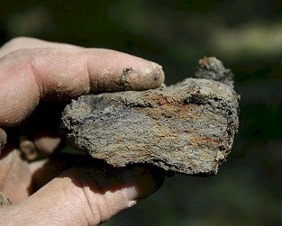 This is an example of a redoximorphic feature. The orange colored material that looks like rust is iron oxide that was moved and deposited by fluctuating groundwater levels.
To keep this simple, these features are basically areas where iron has moved within the soil profile. Soil evaluators can examine a soil profile and find the depth at which redox features first appear. This gives an excellent estimate to the SHWT.
This Earthcache is placed within an area of Rainbow soil. Rainbow soils are not suitable for development because the parent material is dense till, an unsorted mixture of soil materials that was compressed under the massive weight of glaciers 14,000 - 18,000 years ago. This material is extremely difficult to dig through. It also "perches" infiltrating water, causing a high water table. This Earthcache will give you some experience in describing a soil profile and identifying the features that make Rainbow unsuitable for development.
Your Assignment:
You will need: A measuring device (a roll tape will work best) and a small trowel, knife, or shovel to help you clear the profile and obtain samples
The posted coordinates will bring you to a soil pit used during the 2008 National Soil Judging Competition, hosted that year by the University of Rhode Island. The bottom foot or so of this pit may fill with water during the winter and spring. I do not advise anyone to attempt this cache if there is water in the pit.
Clear off the soil face. You will notice some bright brown and orange soil on top of the soil surface. This is soil material that was dug from the pit and cast onto the soil surface. If you look carefully, you should be able to find the original forest floor surface. Begin your measurements from here. Measure the distance from where the original surface meets the soil to where you see a very obvious color change from very dark brown to a more yellowish brown. This layer is the A horizon. It is dark because decaying plant material is a major component of this soil layer. Record the depth of this soil layer.
Next, begin digging small clods of soil from the orange soil materials (B horizon) below the A horizon with your knife or trowel. Break open the clods and look carefully for rust colored redox features. Once you find these features, carefully continue higher in the soil profile to make sure they do not appear higher. Record the depth at which the redox features first appear in the soil profile. This is the estimated depth of the SHWT!
Rhode Island's Department of Environmental Management specifies that conventional septic system leachfields must be located within areas where the SHWT is at least 60 cm beneath the soil surface. Higher water tables require unconventional, more expensive systems. Based on the data you collected, can a conventional septic system be placed at this location?
Congratulations! You just performed some real-life soil evaluating! To log your find, you must answer all three bold questions and email them to me. Do not post any answers in your log. You do not need to wait for a reply in order to log your find.