IT’S MY BATH READY?
NASCENTES TERMAIS

[Homiziados – Açores]


EARTHCACHE
PORTUGUÊS

A ILHA BRANCA
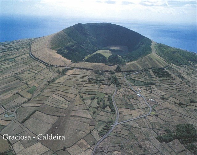
“A ilha Graciosa, classificada pela UNESCO como Reserva da Biosfera, é a segunda mais pequena do arquipélago e é também a de relevos menos imponentes, com várias zonas aplanadas e serras suaves. Pedras Brancas, Serra Branca ou Barro Branco são topónimos da ilha que estão relacionados com a presença de uma rocha vulcânica, o traquito, comum na ilha e que uma vez alterado, apodrecido pelo passar dos tempos, adquire uma coloração esbranquiçada, que faz jus à designação Ilha Branca”.
O TERMALISMO NA ILHA GRACIOSA
O Vulcão da Caldeira da Graciosa apresenta algumas manifestações de vulcanismo secundário destacando-se as emanações gasosas no interior da Furna do Enxofre e as nascentes termais do Carapacho e da Baía dos Homiziados.
Dos 116 “pontos” de água mineral inventariados nos Açores, nove localizam-se na ilha Graciosa, sendo três nascentes e seis furos.

“Presentemente, a actividade vulcânica registada na ilha Graciosa é testemunhada pela existência de várias fumarolas e nascentes termais.
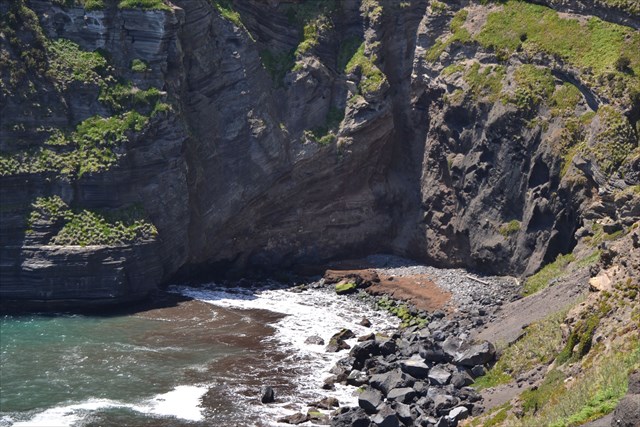
No que concerne às nascentes termais distinguem-se a do Carapacho e a da Baía dosHomiziados, ambas acompanhadas pela libertação de gases: a nascente do Carapacho, conhecida desde 1750 é captada através de um poço e aproveitada para alimentar uma estância termal; a dos Homiziados, referida por Fructuoso (1583?), constitui uma pequena exsurgência na areia da praia, passível de ser observada nos períodos de baixa-mar”.
In Tese de Doutoramento de João Luis Gaspar (atual reitor da Universidade dos Açores)
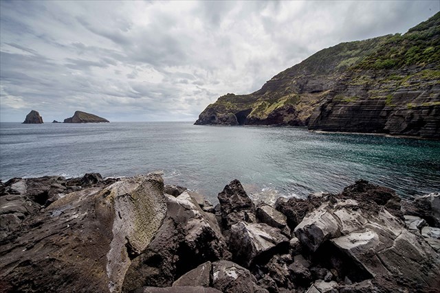
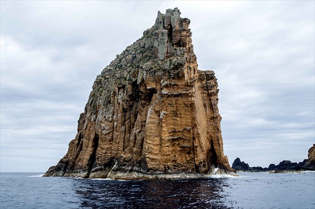
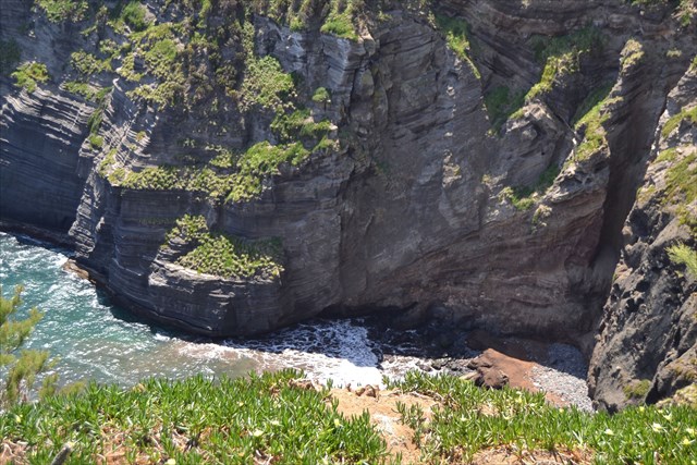
“As Pontas do Carapacho e da Restinga apresentam-se segundo altas falésias onde a erosão costeira pôs a descoberto chaminés, filões basálticos e tufos surtseianos associados à atividade inicial, submarina, do vulcão da Caldeira. O Ilhéu de Baixo constitui os resquícios de um cone de tufos surtseiano, igual testemunho de uma erupção submarina de natureza basáltica em águas pouco profundas. Estas arribas incluem, ainda, depósitos de escórias e de pedra-pomes, esta última proveniente do vulcão da Caldeira.
Nesta área, para além das nascentes termais da Baía dos Homiziados (a Nordeste da Ponta da Restinga), ocorre a nascente termal do Carapacho, de águas cloretadas sódicas e temperatura a variar entre 30ºC e 60ºC (dependendo da nascente em questão…). Esta água é tradicionalmente captada num poço situado no interior do Balneário Termal, construído entre 1947 e 1951 pela antiga Junta Geral de Angra do Heroísmo, e recentemente objeto de reabilitação, ampliação e reformulação das captações. A água termal do Carapacho é aplicada desde, pelo menos, 1750 no tratamento do reumatismo, colites e doenças de pele. Na costa adjacente ao balneário existe uma piscina natural, muito procurada na época balnear”.
Geoparque Açores

NASCENTES TERMAIS
Tipo de fenómeno de vulcanismo atenuado que, após as erupções terem terminado, pode manter-se durante anos. As nascentes termais são nascentes de água a temperaturas elevadas, que podem ter origem vulcânica ou ser originadas por águas superficiais que, ao infiltrar-se, são sobreaquecidas em consequência do aumento de temperatura. Se a água das nascentes termais tem origem magmática denomina-se água juvenil.

OS HOMIZIADOS
NO
GEOSSÍTIO PRORITÁRIO
(Ponta do Carapacho, Ponta da Restinga e Ilhéu de Baixo)
E NO PARQUE NATURAL DA GRACIOSA
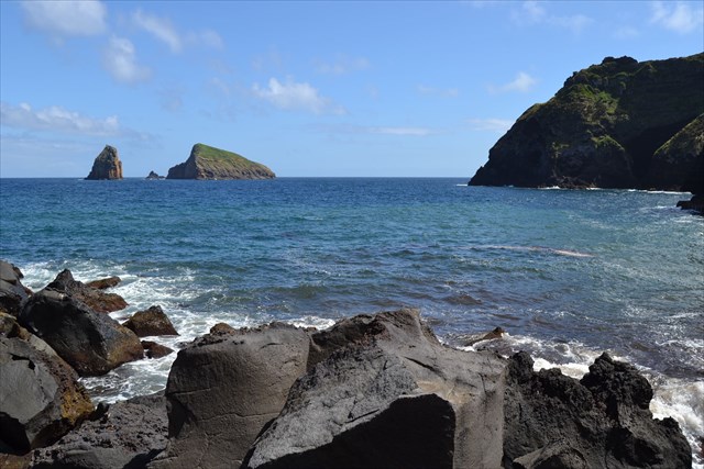
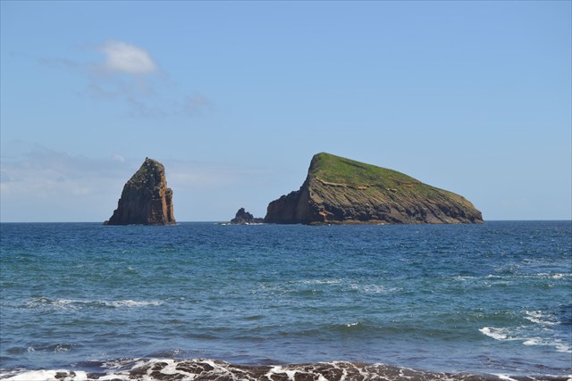
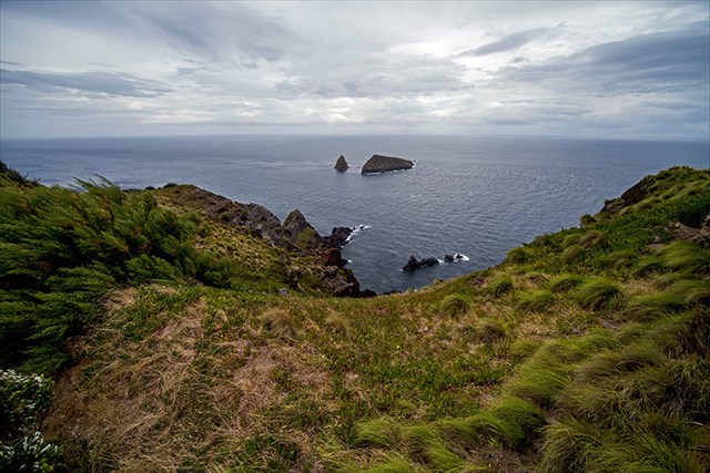
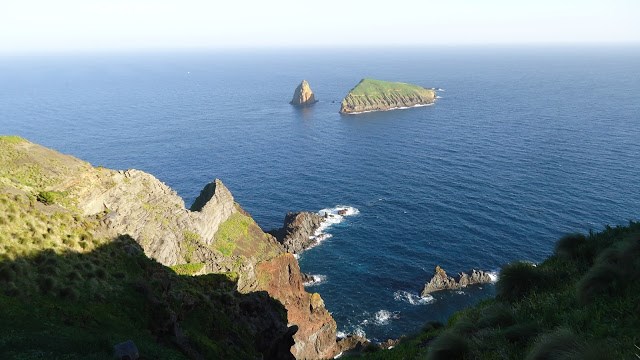
“O Ilhéu de Baixo ocultado na maior parte da extensão da ilha Graciosa pela imponência da Caldeira da Graciosa, torna-se visível com a aproximação à zona sul da Graciosa onde surge fronteiro ao lugar do Carapacho na freguesia da Luz. Situado a SE da Ilha Graciosa a aproximadamente 700 m da Ponta da Restinga tem 9 ha de área e apresenta uma altitude máxima de 74 m.
É também conhecido localmente por Ilhéu do Carapacho. No passado foi denominado por Ilhéu dos Homiziados, assim chamado pelo que relata Gaspar Frutuoso em “Saudades da Terra” devido a um episódio trágico ocorrido em 1541, onde um grupo de 7 mancebos que se aventuram até ao ilhéu por recreação, ficaram retidos devido à escuridão da noite e ao estado agitado do mar. Dias depois foram jocosamente chamados de hominizados (foragidos à ação da justiça) por um outro grupo de 5 rapazes que foram resgata-los, mas a embarcação destes virou por ação de uma onda, tendo morrido 4 dos jovens.
O Ilhéu de Baixo é na realidade constituído por dois ilhéus de origem basáltica e alguns rochedos emersos e está incluído no geossítio prioritário (Ponta do Carapacho, Ponta da Restinga e Ilhéu de Baixo) integrado no Geoparque Açores que foi admitido em março de 2013 na Rede Europeia de Geoparques. Corresponde a um cone de tufos surtseiano estratificado, muito desmantelado pela atividade erosiva e tectónica. A sua origem é posterior à formação da Graciosa e advêm de uma erupção submarina de natureza basáltica, em águas pouco profundas. É possível observar algumas grutas marinhas de erosão submersas ou semissubmersas.

Devido ao difícil acesso para o Homem e a inexistência de mamíferos (ratos, furões, gatos), este ilhéu é uma importante área para refúgio e nidificação de diversas aves marinhas, comportando uma importante colónia de garajaus-comuns, painhos-da-madeira, painhos-de-monteiro (endemismo Graciosense), cagarros, rulhos e existindo também a única colónia de gaivotas-de-patas-amarelas da ilha.
No ilhéu podemos encontrar diversa flora costeira característica dos habitats de falésia e costas de calhau rolado, da qual se destaca a vidália (Azorina vidalii), Spergularia azorica, não-me-esqueças (Myosotis maritima) , erva-leiteira (Euphorbia azorica ), bracel-da-rocha (Festuca petraea).
O Ilhéu de Baixo devido aos seus valores naturais e a sua importância para espécies, habitats e ecossistemas protegidos, integra o Parque Natural da Graciosa, criado pelo Decreto Legislativo Regional n.º 45/2008/A, de 5 de novembro, como Reserva Natural. Este ilhéu é ainda Zona de Proteção Especial (ZPE), Sítio de Importância Comunitária (SIC), Zona Importante para Aves (IBA) e Zona Núcleo da Reserva da Biosfera da Ilha Graciosa”.
Carlos Picanço
Parque Natural da Graciosa

PARA REALIZAR E REGISTAR ESTA EARTHCACHE:
PERGUNTAS:
Para “encontrar/registar” esta cache deverá: provar que esteve no local e responder às seguintes questões, enviando um email/mensagem de Geocaching, com as respostas, em português ou em inglês, para o nosso perfil.
Só depois, de enviar as respostas, e conforme as “guidelines” para as Earthcaches, deverá efetuar o seu registo!
Serão removidos todos os registos que não obedeçam a estes requisitos.
OBSERVAÇÕES IMPORTANTES:
I – É conveniente realizar esta earthcache na maré vazia (baixa-mar) e em dia de mar calmo!
II – É necessário um termómetro (com escala entre 20ºC e 80º C) para realizar esta earthcache.
III - E lembre-se está numa área protegida em questão INTERDITOS os seguintes atos e atividades: abandonar resíduos; colher, capturar, abater ou deter de exemplares de organismos (animais ou plantas) sujeitos a medidas de proteção, em qualquer fase do seu ciclo biológico, incluindo a destruição de ninhos e a apanha de ovos, a perturbação ou a destruição dos seus habitats.
1. Estudando o tema geológico proposto nesta earthcache, responde às seguintes questões:
a) Quais são as manifestações de Vulcanismo secundárias, ainda observáveis atualmente, associadas ao Vulcão da Caldeira da Graciosa?
b) Explica o que é uma nascente termal.
c) Quantos “pontos” de água mineral existem referenciados na ilha Graciosa?
2. A partir da tua visita (percurso) e observações no GZ desta earthcache, responde às seguintes questões:
a) Identifica, pelo menos seis, “fenómenos geológicos” observados durante a tua caminhada até ao GZ.
b) No GZ (entrada da gruta) é, ou não, observável “fumo” ou seja:
emanações gasosas?
c) No interior da gruta (GZ) existem rochas de várias cores: pretas/negras, acinzentadas, acastanhadas, etc...
São visíveis mais algumas cores nestas rochas?
Se sim, quais e explica a razão do aparecimento desta ou destas cores.
d) A partir do WP1 consegue-se observar alguma construção humana?
E durante o percurso até ao GZ?
e) Identifica, a partir da tua observação (cheiro, paladar, etc…) pelo menos três, parâmetros físico-químicos da água termal que brota da nascente da gruta (GZ).
3. Mede, com um TERMÓMETRO, a temperatura da água mineral que brota na nascente principal, identificada nesta earthcache, GZ.
4. TAREFA OBRIGATÓRIA:Deverá tirar uma foto sua, onde você apareça (ou com um papel/placa onde conste o seu nickname e a data da visita) e que comprove a sua presença no GZ desta EC - NÃO META SPOILERS. Esta foto deverá ser colocada no seu registo ou enviada por email ou sistema de mensagens de Geocaching, para o owner!


Não responderemos ao seu contato, a não ser que haja algum “problema” com as suas respostas ou registo.

IT’S MY BATH READY?
THERMAL SPRINGS
[Homiziados – Azores]
ENGLISH

EARTHCACHE
WHITE ISLAND

"Graciosa” Island, a UNESCO Biosphere Reserve, is the second smallest of the archipelago and is also the least impressive reliefs, with several flattened areas and gentle hills. White, Sierra White or White Clay stones are place names on the island that are related to the presence of a volcanic rock, the trachyte, common on the island and once changed, rotted by the passage of time, acquires a whitish color, which lives up to designation White Island ".
THE THERMALISM AT GRACIOSA ISLAND
The Volcano “Graciosa Caldeira” has some manifestations of secondary volcanism highlighting the fumes inside the Sulfur Cavern and the thermal springs of “Carapacho” and the Bay of Homiziados.
Of the 116 "points" of mineral water inventoried in the Azores, nine are located in the Graciosa Island, three springs and six holes.
”At present, the recorded volcanic activity on the island of Graciosa is witnessed by the existence of several fumaroles and hot springs.
Regarding the thermal springs are distinguished the Carapacho and the Bay of Homiziados, both accompanied by the release of gases: the source of Carapacho, known since 1750 is captured through a well and harnessed to power a spa; to the Homiziados referred by Fructuoso (1583?), is a small “exsurgência” on the beach sand, which can be observed in periods of low tide”.
In João Luis Gaspar PhD thesis Luis Gaspar (current Dean of the University of the Azores)

“As Pontas "The Tips Carapacho and Restinga are presented second high cliffs where coastal erosion has uncovered fireplaces, basaltic seams and tufts surtseianos associated with initial activity, underwater, of the Caldera volcano. Ilhéu de Baixo is the remains of a cone surtseiano tufts, like testimony of a submarine eruption of basaltic nature in shallow water. These include cliffs, still slag deposits and pumice, the latter coming from the Caldera volcano.
In this area, in addition to the thermal springs of the Bay of Homiziados (the north-eastern tip of the “Restinga”), there is the thermal spring Carapacho of sodic chlorinated water and temperature range between 30 ° C and 60 ° C (depending on the source in question ...). This water is traditionally captured a well located inside the Thermal Centre, built between 1947 and 1951 by the former General Board of Angra do Heroísmo, and recently rehabilitation object, expansion and redesign of funding. The hot water Carapacho is applied since at least 1750 in the treatment of rheumatism, colitis, and skin diseases. In adjacent to the resort coast there is a natural pool, very popular during the summer season”.
Azores Geopark

THERMAL SPRINGS

Volcanism phenomenon type attenuated that after the eruptions have finished, you can keep for years. The thermal springs are springs at elevated temperatures, which may be volcanic origin or originating from surface waters that infiltrate when they are overheated as a result of temperature increase. If the water from the thermal springs have magmatic origin is called juvenile water.
THE“HOMIZIADOS”
AT
GEOSITE PRIORITY
(“Ponta do Carapacho, Ponta da Restinga e Ilhéu de Baixo”)
AND AT GRACIOSA NATURAL PARK
“O Ilhéu de Baixo "The islet Low concealed most of the extent of Graciosa by the grandeur of the Graciosa Caldera becomes visible with the approach to the south of Graciosa area where appears opposite the place of Carapacho in the village of Luz. Situated SE Island Graciosa approximately 700 meters from the Ponta da Restinga has 9 ha in area and has a maximum altitude of 74 m.
It is also known locally for islet Carapacho. In the past it was called by islet of Homiziados, so named by reporting Gaspar Frutuoso in "Miss Earth" because of a tragic episode occurred in 1541, where a group of seven young men who venture to the islet for recreation, were stranded due to darkness of the night and the busy sea conditions. Days later they were jokingly called “hominizados” (fugitives to the action of justice) by another group of 5 boys who were rescued them, but the boat turned these by action of a wave, having died four young people.
Ilhéu de Baixo is actually made up of two islets of basaltic and some emerged rocks and is included in the priority geosite (Ponta Carapacho, Ponta da Restinga and Low Islet) integrated in the Azores Geopark which was admitted in March 2013 on the Net European Geoparks. Corresponds to a cone stratified surtseiano tufts, very dismantled by the erosive and tectonic activity. Its origin is after the formation of Graciosa and come from an underwater eruption of basaltic nature, in shallow water. You can see some sea caves submerged or semissubmersas erosion.
Due to the difficult access to the man and the absence of mammals (mice, ferrets, cats), this islet is an important area for shelter and nesting several seabirds, comprising a large colony, Common terns, Madeiran storm petrels, Monteiro storm petrels (Graciosa endemism), Cory's Shearwaters, Barolo shearwater and there is also the only colony of seagulls-of yellow-legged on the island.
In the islander we can find diverse flora coastal feature of the cliff habitats and back of shingle, which highlights the Azorina vidalii, Spergularia azorica, Myosotis matitima, Euphorbia azorica Festuca petraea.
The Low Islet because of its natural values and its importance to species, protected habitats and ecosystems, integrates Graciosa Natural Park, created by the Regional Legislative Decree No. 45/2008 / A, November 5, as a Nature Reserve . This islet is also Special Protection Area (SPA), Site of Community Importance (SCI), Zone Important for Birds (IBA) and Zone Nucleus of Graciosa Island Biosphere Reserve ".
Carlos Picanço
Graciosa Natural Park

TO PERFORM AND LOG THIS EarthCache:
QUESTIONS:
To "find / register" this cache must: prove that visited the site and answer the following questions by sending an email / message Geocaching, with answers (in Portuguese or in English, only) to our profile.
Only later, sending the answers, and as the "guidelines" for EarthCaches should make your registration! They will be removed from all records that do not meet these requirements.
INPORTANT COMMENTS:
I - It is convenient to perform this EarthCache in low tide and days of calm sea!
II - a thermometer (with range between 20 ° C and 80 ° C) to carry out this EarthCache is required.
III - And remember, is a protected area in question PROHIBITED the following acts and activities: abandon waste; harvest, capture, kill or detain copies of organisms (animals or plants) subject to protective measures at any stage of their life cycle, including the destruction of nests and the collection of eggs, disruption or destruction of their habitats.
1. Studying the geological theme proposed this EarthCache, answers the following questions:
a) What are the manifestations of secondary volcanism still currently observable associated with the Graciosa Caldera volcano?
b) Explain what a thermal spring is.
c) How many "points" of mineral water are referenced in Graciosa Island?
2 From your visit (route) and observations in this GZ EarthCache, answers the following questions:
a) Identify at least six, "geological phenomena" observed during your walk to the GZ.
b) GZ (cave entrance) is or not observable "smoke" that is, gaseous emanations?
c) Inside the cave (GZ) there are rocks of various colors: black / black, gray, brownish, etc ...Are visible some more colors in these rocks?
If so, what and explains the reason for the appearance of this or these colors.
d) From the WP1 one can observe some human construction?
And along the way to the GZ?
e) Identify, from your observation (smell, taste, etc...) at least three physico-chemical parameters of thermal water that flows from the source of the cave (GZ).
3. Measured with a thermometer, the temperature of the mineral water spring in the main source, identified in this EarthCache, GZ.
4. TASK (not optional): You must take a picture of yourself, where do you show up, (or with a paper / plaque with your geocaching nickname and the date of the visit) and that proves your presence in the GZ of this EC - no spoilers please. This photo must be placed in your log or sent by email or Geocaching messaging system, to the owner!


We do not respond to your touch, unless there is a "problem" with their answers or register.