Mountain Pass
A mountain pass is a route through a mountain range or over a ridge. Since many of the worlds mountain rages have presented formidable barriers to travel passes have been important since before recorded history.
Mountain passes make use of a gap, saddle or col. A topographic saddle is analogous to the mathematical concept of a saddle surface, with a saddle point marking the highest point between two valleys and the lowest point along a ridge.
The top of a pass is frequently the only flat ground in the area, a high vantage point, as can be see here. As well as offering relatively easy travel between valleys, passes also provide a route between two mountain tops with a minimum of descent. As a result, it is common for tracks to meet at a pass; this often makes them convenient routes even when travelling between a summit and the valley
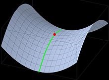
Idealized mountain pass represented as the green line; the saddle point is in red.
Formation of the Physical Landscape
The physical landscape we see before us today is a combination of a number of developments, some of which stretch back, hundreds, thousands and even millions of years. These include,
1. The mountain building and other changes associated over hundreds of millions of years with global level plate tectonics.
2.The denudation and weathering process still opperating now and have been opperating for tens of millions of years
3. The impact of ice ages involving several glaciations and deglaciations within the last million years.
These events and processes in combination largely determine the composition of the landscape in terms of rocks and soils, and it's shape or appearance
To log this Earthcache
Please contact me through my profile with the answers to the following questions. Please send the answers BEFORE logging your find but if you feel you have answered correctly then you don't need to wait for an answer, I will contact you if there is a problem.
1. Do you think the flat land that you are standing on now is an entirely natural landscape, or has man had a hand in making it so. Why do you think this.
2. You can see the sea from here, and where you are standing is 215m above sea level, please estimate the height of Beenarourke, which is the high point to the west of you.
3. Do you think the land formation here is primarily due to 1, 2, or 3 above. Give your reasons
4. Photos of your visit here are most welcome but not a requirement.