Nutfield's Marsh EarthCache
-
Difficulty:
-

-
Terrain:
-

Size:  (other)
Please note Use of geocaching.com services is subject to the terms and conditions
in our disclaimer.
Nutfield's Marsh
Welcome to Nutfield Marsh.
I have been visiting this wonderful and fascinating area for over fifty years, so I hope you enjoy your visit, learn something new and have a really great adventure 
What is a marsh?
A marsh is a wetland that is dominated by herbaceous rather than woody plants.
They are often dominated by grasses, rushes or reeds, and if woody plants are present they tend to be low-growing shrubs. This form of vegetation is what makes marshes different from other types of wetland, such as swamps, which are dominated by trees and mires.
There are three main types of marsh; Saltwater Marsh, Freshwater Tidal Marsh, and Freshwater Marsh.
1 - Saltwater Marsh
Saltwater marshes are located close enough to the shoreline to be affected by the tides, and are periodically covered by water.
They are most commonly found in lagoons, estuaries, and on the sheltered side of shingle or sandspit, where currents deposit fine particles and sediment then begins to build up.
They are dominated by specially adapted rooted vegetation, which are primarily salt-tolerant grasses.
2 - Freshwater Tidal Marshes
Although considered a freshwater marsh, this form of marsh is also affected by the tides. However, without the salinity of the saltwater marsh, the diversity of the plants and animals that live in and use these marshes is much higher than in saltwater marshes.
3 - Freshwater Marshes
Freshwater marshes are found along the fringes of lakes and rivers where the water table is high. They vary in size from small depressions to large watery grasslands.
The vegetation in this type of marsh depends on the presence of water.
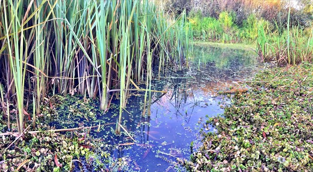
Some marshes, such as the wetland meadow do not have any standing water for most of the year, and therefore do not support aquatic plants. However, insects, especially butterflies, flourish in them. Other marshes are far more aquatic and support aquatic plants and life, such as water lilies, reeds and frogs.
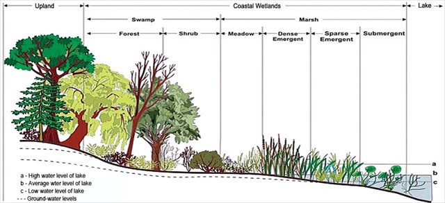
Diagram of a Marsh
Where is Nutfield Marsh?
Nutfield Marsh lies to the east of Redhill. The earliest documentary reference to Nutfield Marsh stretches back to 1086 in the Domesday Book, where it shows that the Countess of Boulogne held the estate, or manor, of Notfelle (Nutfield).
By the mid-19th century the parish was probably not very different from that of the Domesday manor, although there have been several boundary changes in more recent times. The extensive stretches of common land have gradually been absorbed over the years into the surrounding farmland.
Many pieces of land on Nutfield Marsh cultivated over the centuries, but now only two fields remain for growing crops, at Chilmead Farm and Mercers Farm. Now unconnected to the farmed land, the listed farmhouse at Chilmead Farm has been converted into homes and the one at Mercers Farm has been virtually demolished and rebuilt as a number of smaller dwellings and its extensive outbuildings converted into homes.
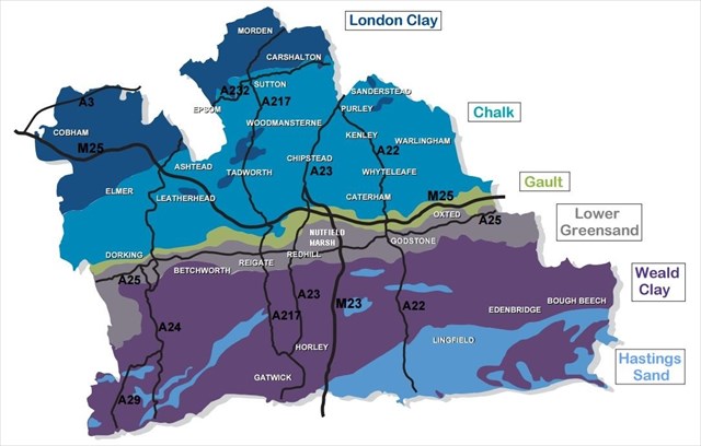
Geology
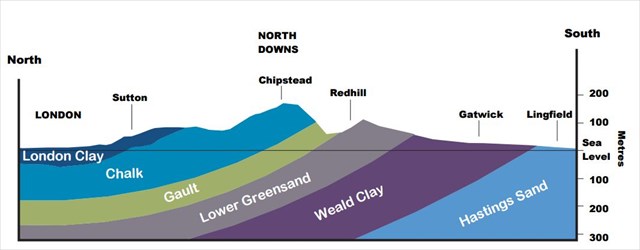
Geology Section
The Nutfield Marsh Nature Reserve
The Nutfield Marsh Project has created four wetland nature reserves, restored from sand workings, along Redhill Brook. This is a fantastic place to explore and all the reserves are easily accessible along public footpaths, which are shown on the map (below).
1 - The Moors
Moors is an old Saxon word for marsh, and surviving Saxon documents describe this area as ‘marshy with black peaty pools’. Cattle graze the marsh and permanent pools ensure wetland habitat is available all year round.
In autumn, snipe, and other waders, arrive for winter and ducks flock to feed on the flood. In summer the pools are alive with small damselflies and bigger dragonflies.
2 - Mercers West
This is the site of a former sand quarry and restoration is just being completed. This site is good for wintering waterfowl, and the sand faces have successfully been left for breeding sand martin. Wading birds such as green sandpiper can be seen on the muddy banks.
3 - Holmethorpe Lagoons
This is the site of the former sand processing works, and is being restored as part a nearby housing development. This reserve is already attracting waterfowl and dragonflies.
4 - Spynes Mere
This is also the site of a former sand quarry, but before sand was extracted the area was farmland. Spynes is a very old word, in use before the Norman Conquest to describe the area. It means summer fattening pasture, and is correctly pronounced spines, like the spine of a thorn. It is now home to many waterbirds. They are at their greatest numbers in winter. The big south facing grassland slope is excellent for butterflies and grasshoppers, food of the common lizard and slow worm, which you might see basking in sunny spots nearby.
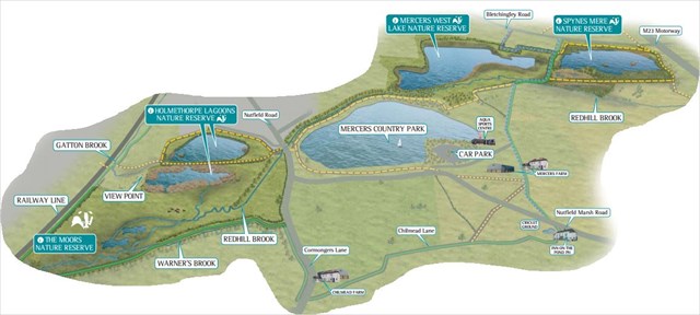
Map of Nutfield Marsh Nature Reserve
Important Information
To begin your adventure head for Waypoint 1 at N 51° 14.850 W 000° 08.277 and follow the instructions at 'Tasks' (below).
To claim this EarthCache as a find please send your answers to me by either using the message centre, or email. All emails should show your caching name (eg terrapintim) and email address and they should be sent to my email through my profile. Your answers should be sent to me BEFORE YOU LOG YOUR FIND, and afterwards you can then log the cache as a find and upload your photo (if you choose to do so). Please DO NOT reveal any of the answers in your log! Finally, you DO NOT have to wait for my reply, as I will contact you if there are any problems with your answers. I will however do my best to respond out of courtesy as soon as possible 
Tasks
1. At Waypoint 1 take an elevation reading and send it with the following: Examine the soil beneath your feet and describe what it feels like and whilst facing towards Waypoint 3 briefly describe the landscape behind you.
2. At Waypoint 2 take an elevation reading and send it with a brief description of the landscape around you.
3. At Waypoint 3 take an elevation reading and send it with the following: Examine the soil beneath your feet and describe what it feels like and whilst facing forwards briefly describe the landscape in front of you.
4. Compare your elevation readings and the changes in the soil, what does this tell you about the area you have just walked on? Is this what you expected in a marsh, and explain why you have come to this conclusion.
5. Finally, read the information about the different types of marsh, and explain what type of marsh iNutfield Marsh, is, and explain why you have come to this conclusion.
Optional Task
6. As an optional extra take a photo of you/your GPSr with the marsh at Waypoint 3 (N 51° 14.986 W 000° 08.165) behind you and post it with your log.
Additional Hints
(No hints available.)