Black Mountain Lookout Tower Traditional Geocache
Black Mountain Lookout Tower
-
Difficulty:
-

-
Terrain:
-

Size:  (regular)
Related Web Page
Please note Use of geocaching.com services is subject to the terms and conditions
in our disclaimer.
The first tower built on Black Mountain was a35 foot log tower built in 1911. It was in service until 1918 when it was replaced with the 35 foot steel LS-40 Aermotor you see there today. In 1988 the lookout tower was closed and put out of service. At that time a 39 foot communications antenna was installed above the cab as part of the state police communications system. On the summit is also a wind generator and huge solar panels to power the communications equipment. The tower has a new life supporting critical communications equipment and is not accessible to the public.
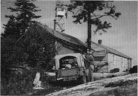
At one point, and I'm not sure of the date, there was an airway beacon mounted atop the watchman's cab. The beacon can be seen in the picture to the left. The beacon was part of a navigation guidance system from Burlington to Albany which was retired as radar came into use. The light was powered by acetylene gas which came in 200 pound tanks.
The original watchman's cabin was replaced in 1958 with a 3 room cabin. Until last year the watchman's cabin was still standing proudly against the wind. Sometime since October 2005 the cabin has been removed and all that remains is the concrete piers that once supported it.
At one time there was a jeep road to the top but now it is barely accessible by snowmobile in the winter. No other motor vehicles are allowed on the mountain.

There are two ways to access the summit of Black. One is from the shores of Lake George with the trail starting at Black Mountain point. This is a steep and strenuous hike with many switchbacks and great views all along the 2.8 mile hike each way. The summit can also be accessed from the east off Pike Brook road. The trail head is about .8 miles south on Pike Brook road from Huletts Landing road. From Pike Brook its mostly flat hiking for the first half then a gradual assent to the top for a total of 2.5 miles each way..
I have adopted this cache from Chris Porth and have replaced the container with a 30 cal ammo can. If you are a benchmark hunter there is one up here along with two reference marks although one reference mark is inside the fence and hard to see.
To find this cache you will need to approach from above. When you get to ground zero you will see a semi pointed rock sticking up. Step over the edge to a shelf 2 feet below. The cache is in slid in a hole at your feet.
Additional Hints
(Decrypt)
Ba ebpx furys va ubyr ng lbhe srrg fgnaqvat ba furys