Quiero agradecer a mi amigo Jorge su colaboración. Sin su ayuda, colocar este caché me hubiera sido muy complicado.
My friend Jorge helped me to lay down this caché. Thank you Jorge!
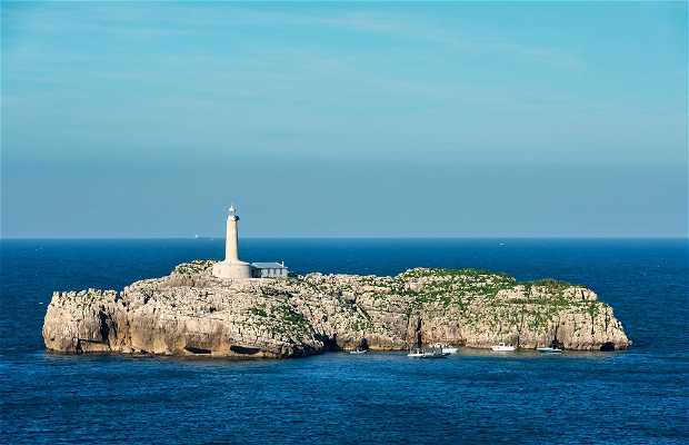
La isla de Mouro se encuentra en la entrada de la bahía de Santander. No es muy grande ni tiene una fauna o flora destacable, pero es el punto de referencia para entrar en la bahía de Santander, y también es el rompeolas que la proteje. Es una isla rocosa y en su parte superior hay un faro que está en servicio desde 1860 (más información en https://es.wikipedia.org/wiki/Faro_de_Mouro
El acceso a la isla es complicado. Puedes acercarte en barco, pero deberás nadar los últimos metros hasta alcanzar el inicio de la escalera de piedra que sube hasta el faro. También, para los más aventureros, existe la opción de nadar o acercarse en canoa o SUP partiendo desde el muelle de la Magdalena, una travesía de unos 1000 metros.
The island of Mouro is located at the mouth of Santander bay. It is not big nor it has a noticeable wildlife, but it is the reference point when entering the Santander bay, and protects the bay being its breakwater . The island is made of rocks and there is a lighthouse on the top (more info at https://es.wikipedia.org/wiki/Faro_de_Mouro)
Getting to the island is a complicated task. You may try a ship, but you will have to swim the last meters until you get to the firsts steps of the rocky stair that will take you to the lighthouse. The brave ones may try to swim or paddle from the Magdalena´s pier, some 1000 meters away.
ATENCIÓN
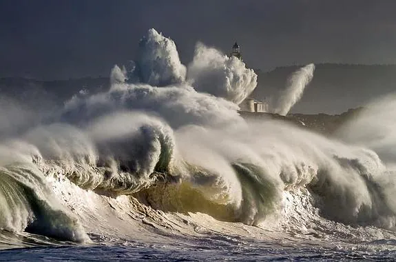
CON MALA MAR EL ACCESO A LA ISLA ES EXTREMADAMENTE DIFICIL Y PELIGROSO, SIENDO IMPOSIBLE DURANTE UN TEMPORAL.
SI LO VAS A INTENTAR A NADO DEBERÁS TENER EN CUENTA, ADEMÁS DEL ESTADO DE LA MAR, LA TEMPERATURA DEL AGUA, QUE EN INVIERNO CAE HASTA LOS 12 GRADOS CENTÍGRADOS, Y ARRASTRAR UNA BOYA DE SEÑALIZACIÓN PARA QUE LOS BARCOS TE VEAN Y PUEDAN ESQUIVARTE.
NINGÚN CACHÉ MERECE QUE ARRIESGUES TU VIDA POR CONSEGUIRLO!!
WARNING
GETTING TO THE ISLAND IS EXTREMELY DIFICULT AND DANGEROUS IN FOUL WHETHER, AND IT GETS IMPOSIBLE IN A GALE.
IF YOU WANT TO GIVE IT A TRY SWIMMING ACROSS THE CHANNEL, YOU HAVE TO TAKE INTO CONSIDERATION NOT ONLY THE SEA STATE BUT THE WATER TEMPERATURE, BECAUSE IT DROPS TO 12 DEGREES CELSIUS IN WINTER TIME. DON´T FORGET TO BRING YOUR PULL BUOY TO MAKE YOU VISIBLE!
THERE IS NO CACHÉ WORTH RISKING YOUR LIFE!!