Is this an esker?
New England has many geological features that owe their existence to the glaciers that covered the area. If you spend any time in New Hampshire woods you'll be familiar with glacial erratics, boulders left by the glaciers. You may also be familiar with kettle holes, cirques, moraines, and striations.
Another glacial landform with which you may not be as familiar is an esker. In New England, eskers have often been referred to as "horsebacks" or "whalebacks". The word esker comes from an Irish Gaelic work, "eiscer," meaning "ridge." Eskers are aligned parallel to former ice flow which means in a valley the esker will be oriented down-valley as compared with moraine ridges that will run across the valley.
Eskers can vary in shape and size bit are typically sinuous, think snake, with heights from a few meters to tens of meters. Most are fairly short. They can be broad or have a single crest or be split into parallel ridges. But eskers can be large: the ragged finger-like protrusions of land north and east of Maine's Casco Bay - the Harpswells, Bailey Island, the Boothbays - are eskers. One esker chain stretches 14 miles from Lyme to West Lebanon down the Connecticut River Valley.
Eskers are usually formed of washed sand and gravel which means that they are targets for people removing that gravel. You can think of an esker as a cast of a tunnel under glacier or an ice canyon or an inverted river, the basic idea being that water flowing through the tunnel under the ice or the ice canyon pushes the gravel and rocks along the tunnel or canyon path. Ice tunnels can be within the ice which means that the sediments will be distributed as the ice melts.
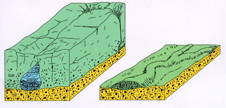
Eskers aren't continuous because the sedimentation may not happen consistently along the tunnel floor. Kettle holes can be created by large chunks of ice falling into the tunnel or an esker ridge may be segmented by erosion.
Eskers usually show up at the margin of glaciers or ice sheets during ice retreat or stagnation. The accumulation of the esker requires a lot of sediment and lots of meltwater flow which typcally happen when glaciers melt.
This esker is located along a portion of Amherst NH's Bicentennial Trail maintained by Amherst's Conservation Commission with their permission.
To receive credit for this EarthCache please email the cache owner your best answers to the following questions. The goal is to show that you've learned something about eskers and that you've actually been to the site.
1. In your email briefly describe how an esker is formed.
2. From the cache coordinates what cardinal directions does the esker go (north, south, east, west, etc.)?
3. Why does the esker go in those directions?
4. Look around you, what do you see on the ground (other than the tree roots) that might provide clues to the fact that you are standing on an esker?
5. What bisects the esker at N 42° 53.315 W 71° 36.846
6. Estimate, perhaps by pacing, the length of the esker from where it starts to where it ends. How many feet would you estimate it stretches?
Enjoy!
FTF: Team Bullis & 76-CJ7
Information on the Bicentenial Trail
Content taken from the following sources:
http://www.landforms.eu/cairngorms/esker.htm
https://newenglandtravelplanner.com/geology/index.html
https://www.des.nh.gov/organization/commissioner/pip/publications/geologic/documents/geologyofnh1.pdf
https://www.dmr.nd.gov/ndgs/ndnotes/eskers/eskers.asp