Come and enjoy the views at 1,922 metres (6,306 ft) high
Length : 11km one way
Walk : 4-5 hours one way
Track : Rocky and rough in places especially towards Mt Feathertop
Grade : Steep
Start & Finish : Diamantina Hut Car park

Be Prepared
This hike requires that you have a sufficient level of equipment (in good working order), fitness and self-reliance. A hiking map or GPS with topo maps is recommended. You will need plenty of drinking water, sun protection, first aid kit and food.
. . .
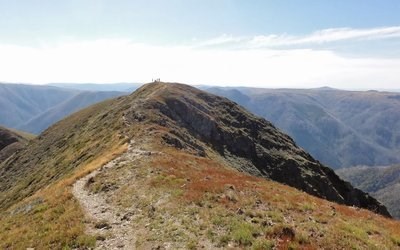
Mount Feathertop is the second-highest mountain in the Australian state of Victoria and is a member of the Australian Alps located entirely within the Alpine National Park. It rises to 1,922 metres (6,306 ft) and is usually covered in snow from June to September. Unlike many other Victorian mountains, Mount Feathertop has steep summit slopes instead of a rounded summit dome. Snow remaining in the summit gullies in spring gives the appearance of feathers - hence the name "Feathertop".
The main access routes on Mount Feathertop are the Razorback (north and south), Bon Accord Spur, Bungalow Spur, North-west Spur, and Diamantina Spur. Hiking on the East Ridge, North-east Spur, and Champion Spur has been possible at times after fires but the routes are now overgrown and rarely used. The North Razorback track is the shortest and easiest route to Mount Feathertop but it is along a ridgeline and can be very exposed during bad weather. It is possible to drive to within 4 kilometres of the summit during summer but a winter road closure leaves a walk or ski of 7.3 kilometres. The South Razorback is a very popular walk in summer and it is a spectacular ski tour in winter. It starts at Diamantina Hut on the Great Alpine Road near the Mount Hotham ski resort and is relatively flat but is also very exposed during bad weather. The south Razorback track covers a distance of 11 kilometres from its start to the summit.
See You There!