Coastal Erosion - An Uphill Battle
Welcome to Jamestown's Seaside Beach! As you enjoy the peaceful views of Naragansett Bay, lets take a momen to look at some man made structures, and how they affect the dispersion of sand along the shoreline. Please remember that this is an Earthcache, as such there is no container to find; instead you will need to take the time to make some observations on scene and answer the questions at the bottom of this page. If your answers to the questions are not received in a timely manner your found log may be deleted. Enjoy this Earthcache and your time in Jamestown!
The Ocean State
Rhode Island is the smallest state in the union, yet the addmitably tiny state is home to more than 400 miles of coast. It's little wonder that the state is known as "The Ocean State." In the wake of rising sea levels, urbanized development creeping closer to the water's edge, and increased tourism the question inveitably turns to "how can we stop beach erosion?" Different methods of coastal erosion control methods have been employed over the years. In this lesson we will examine one of the most popular methods, and look at the consequences of its usage.
Stopping Mother Nature
Jettys serve a multitude of purposes, they can be used to form fishing piers, to protect ships as they enter a harbor, and as a way to attempt to prevent beach erosion.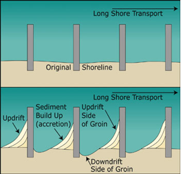 In the 1950s, 1960s and 1970s, jetties and groins were considered the ultimate form of beach preservation. These man-made structures are designed to stymie the movement of sand away from the beach. As can be seen in the image to the right, these groins and jetties capture sands on the side where currents are coming from and remove sand on the side where currents are moving to. The interruption of the current flow helps keep sand deposits on the beach instead of being swept out to sea.
The jetty where you currently stand is a perfect example of a groin and how they affect sedminent erosion and distribution.
What Exactly is a Groin
Groins are an example of a hard shoreline structure designed as a so-called "permanent solution" to beach erosion. A groin is a shoreline structure that is perpendicular to the beach. It is usually made of large boulders, but it can be made of concrete, steel, wood or even sandbags!  It is designed to interrupt and trap the longshore flow of sand. Sand builds up on one side of the groin (updrift accretion) at the expense of the other side (downdrift erosion). If the current direction is constant all year long, a groin "steals" sand that would normally be deposited on the downdrift end of the beach4. The amount of sand on the beach stays the same. A groin merely transfers erosion from one place to another further down the beach. As soon as one groin is built, property owners downdrift of it may start clamoring for the government to build groins to save "their" beach. Eventually, the beach may become lined with groins. Since no new sand is added to the system, groins simply "steal" sand from one part of the beach so that it will build up on another part. There will always be beach erosion downdrift of the last groin4.
So How Do We Save Beaches?
Beach replenishment is a costly and neverending project. Groins rob sand from one part of the beach to save another. So what is the best way to save our beaches? The best way is to simply leave the beach alone. Mother nature knows best how to protect the shoreline.
 By moving properties, structures and traffic farther back from the shoreline we allow the beach to naturally form while interacting with the tides and currents. Ironically it's by intervening in natural processes that we cause the very erosion we're striving to avoid. In the Ocean State, this isn't always possible. While there are certainly many miles of our shoreline that are protected as wildlife sanctuaries, protected areas, and restricted acess areas, still plenty more are becoming more and more developed. As we develop closer to our beaches we need to be wary of damaging them in our attempts to protect them. We may be doing more harm than good.
Logging your Earthcache
In order to log your Earthcache you must message the CO (using the link at the top of the cache page) with the answers to the following questions. If I fail to receive your answers in a timely manner, then your log will be deleted. I will always give you a warning prior to deleting a log.
- You are currently standing at the base of a groin. Based on the build up of sand and significant signs of erosion nearby, which direction is the predominant longshore current?
- Based on what you have read and what you have observed here, do you think the groins are an effective tool at stopping erosion? Why or why not?
- Longshore currents remove sand from the beach, but it's not the only source of erosion. Based on your observations, what is another prominent form of erosion?
- (Optional) Post a photo of yourself, your GPS or your group at GZ.
Sources
- http://coastalcare.org/educate/shoreline-engineering/
- http://www.beachapedia.org/Shoreline_Structures
- https://www.visitrhodeisland.com/things-to-do/beaches/