Arundel Castle
The castle at Arundel was built in the late 11th Century by Roger de Montgomery, Earl of Arundel and 1st Earl of Shrewsbury (1005-1094) who was one of the Norman nobles who defeated Harold in 1066. They were given huge estates of land by William of Normandy following the conquest, and this is borne out in the history of the castle and its owners.
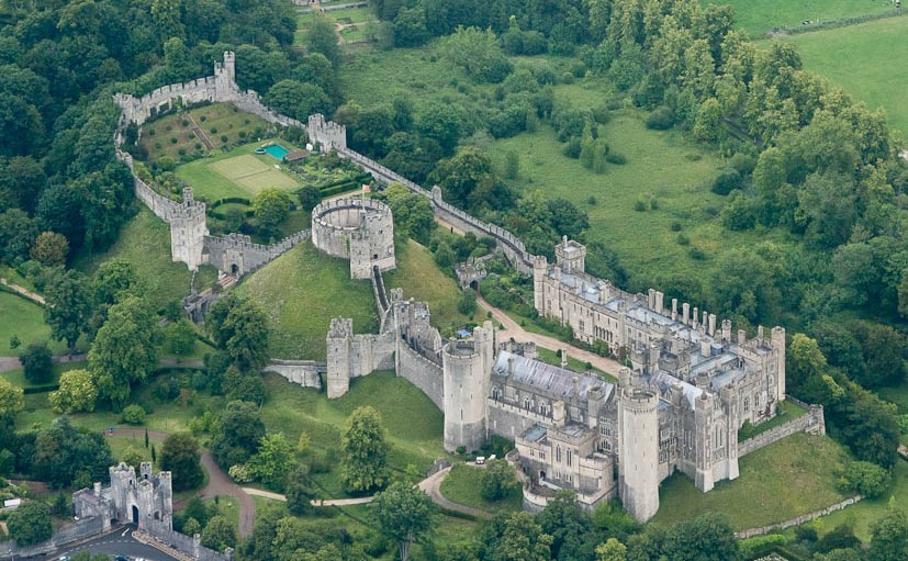
The motte is the oldest feature – it is an artificial mound over 100 feet high from the dry moat, and was built in 1068. The gatehouse was constructed just two years later. The castle and lands were “settled in dower” by King Henry I to his second wife Adeliza of Louvain, as a provision for her in widowhood. Three years after Henry’s death, Adeliza married William d'Albini II, and he built the stone shell keep on the motte. King Henry II built much of the oldest part of the stone castle, and in 1155 he confirmed William D’Albini II as Earl of Arundel, with the Honour and Castle of Arundel.
The castle has descended from the Albini family to the Fitzalans and the Howards (female heiresses transferring ownership by marriage), to the present day, reverting occasionally to the Crown, over the last 850 years, and is still a residence of the current Duke of Norfolk.
There is plenty of history online about these families. The Howards particularly were at the forefront of royal and political English history in Tudor and Civil War times – the 3rd Duke of Norfolk (1473-1554) was uncle to Anne Boleyn and Catherine Howard, both of whom became wives of King Henry VIII.
The castle was badly damaged during two sieges in the Civil War (1642-45), with Royalists and then Cromwell’s Parliamentarians taking control. Repairs and developments were subsequently undertaken in succeeding generations of the Howard family, particularly Henry, 15th Duke of Norfolk (1847-1917), who completed the restoration in 1900. It was one of the first English country houses with electric lighting, integral fire fighting equipment, service lifts and central heating. Both the castle and the town benefited from a gravity fed water supply.
The evidence of this continuous ownership and family history are on display to visitors to the Castle, including a collection of fine 16th Century furniture, tapestries, clocks, and portraits by Van Dyck, Gainsborough, Reynolds, Canaletto and others. Personal possessions of Mary, Queen of Scots and a selection of historical, religious and heraldic items from the Duke of Norfolk's collection are also on display.
The Duke of Norfolk’s private archive collections at Arundel comprise documents from the 12th to the 20th century, for the southern estates in Norfolk, Suffolk, Surrey, Sussex and London.
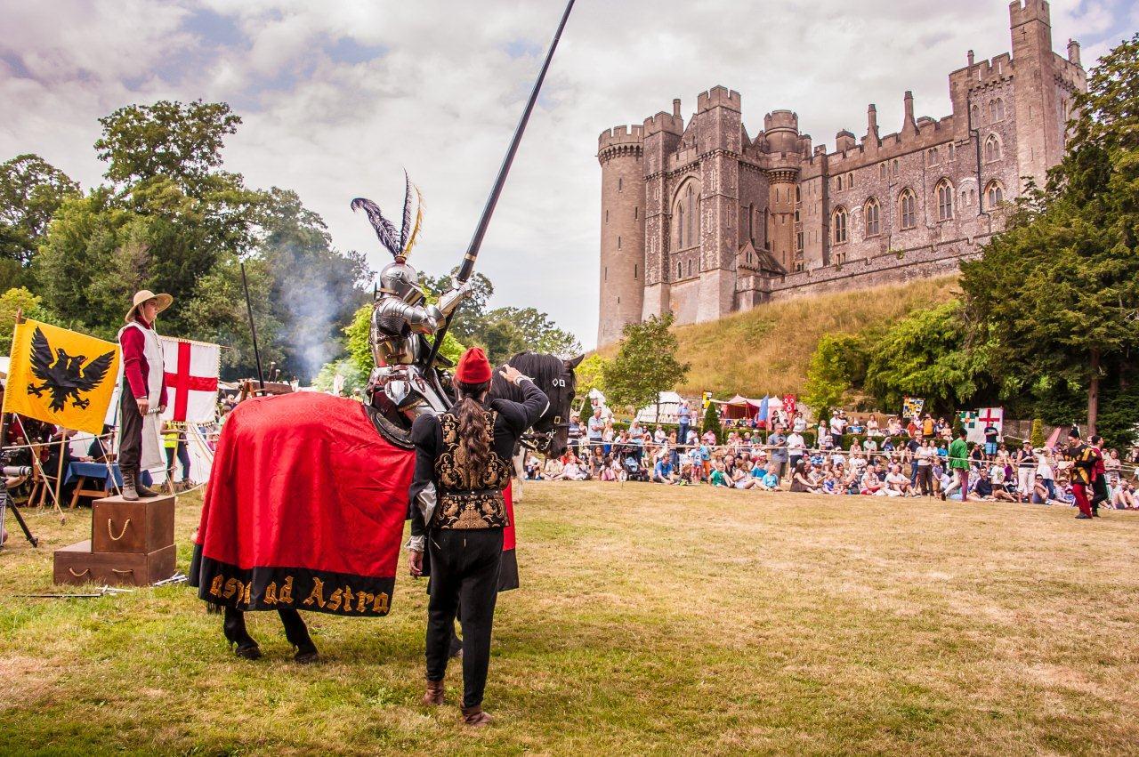
The grounds and castle are open to the public between April and October each year, and special events prove extremely popular (re-enactments and living history days, medieval tournaments, open-air theatre events and more). The town of Arundel holds a week-long festival in August, and other events such as Corpus Christi (carpet of flowers in the Cathedral) and Arundel by Candlelight in the winter. Needless to say, parking is very restricted at these times, but Arundel rail station is a moderate walking distance from the town with direct links to London via the Arun valley, and southwards to Brighton (via Littlehampton) and Portsmouth and beyond (via Barnham). Local buses also serve the area.
THE CACHE
This is a virtual cache, set as part of the Virtual Rewards 2.0 series, a limited release of 4000 caches worldwide. There is no physical cache to find – instead, you need to visit the location and the additional Waypoints, and find answers to the questions below, then send them to me to claim the find.
The posted co-ordinates will take you up to the top of the High Street. If you are driving to Arundel, this spot is reached via a small one-way system from London Road (past the Cathedral) and Maltravers Street, coming from the south-west; or looping from the northbound steeper High Street. There are a few parking spaces here when the town is not busy. Waypoints have been added for alternative parking places, which are also handy for other caches in the area or just for some lovely walks around and out of town.
Accessibility – this is a moderately steep hill so maybe not suitable for unmotorized wheelchairs and I wouldn’t recommend cycling up or down. Light buggies should be OK as long as you’re fairly fit. There are seats where you can take a rest! Please note the corner at the foot of the hill is generally busy with pedestrians and vehicles so take care at that point. One waypoint requires you to cross the road (dropped kerbs are available).
What to do - You can start the cache at the posted co-ordinates at the top, or at the Mill Road waypoint at the bottom, near the large car park (with parking charges) and the Museum.
As you reach each waypoint there is a little task for you to do, as your evidence that you have visited and not just used other methods and claimed from your comfy sofa! It's interesting, but not essential to claim the cache, to take elevation readings at waypoints A and E. You may have this facility on your GPSR; or you can download a phone app like "My Elevation" which works well for me.
Please use the Message or Email (on my profile) with your elevation readings and the answer to each question for the waypoints. Please do NOT post the answers in your log or in any photos you upload. You are welcome to include other photos if you wish.
WAYPOINTS AND TASKS
A – The Top: High Street
Castle Gatehouse (vehicle exit) with view south-east to Crossbush, and west towards the Cathedral. Facing west, note the window in the wall to your right, with a lantern above. What is the number below the window? Good spot for a photo here.
AND (if you can): Using your GPSR or a phone app, take a reading of your elevation at this point (feet or metres).
B – Arundel Jailhouse
Cross the road (dropped kerbs just uphill of the Maltravers Street junction), to the waypoint. At the end of the passageway (Duke’s Path) between two restaurants, you can see the Jailhouse. The building is rife with tales of hauntings by some of the former inmates! In the gate and two side panels – how many V shaped notches (top and bottom)?
C – Coat of Arms
Imposing hotel halfway between the top and the bottom. A heraldic coat of arms is suspended above the path. How many holes in the belt (including the buckle)?
D – Merchants Hall
Between a brick built antiques shop and timbered burger shop (!) – down the passageway “To Merchants Hall” – how many steps at the end to take you through the red door? (visible from the street if the gate is locked).
E – The Bottom: Mill Road
Carefully negotiating the busy corner between the High Street and Mill road, find the information board near the Castle public entrance. How many monks, and which hand is raised?
AND (if you can): Using your GPSR or a phone app, take a reading of your elevation at this point (feet or metres). What's the elevation difference between the top and the bottom?
This Virtual Cache is part of a limited release of Virtuals created between June 4, 2019 and June 4, 2020. Only 4,000 cache owners were given the opportunity to hide a Virtual Cache. Learn more about Virtual Rewards 2.0 on the Geocaching blog https://www.geocaching.com/blog/.