|
 Deutsche Beschreibung Deutsche Beschreibung
Um Wein anzubauen, braucht man neben einem sonnigen Südhang und einem günstigen Klima vor allem eines: einen guten Boden. Welcher das im Heilbronner Raum ist und wie er entstanden ist, darum geht es hier.
Bei diesem Cache könnt ihr keine Dose finden. Um ihn zu loggen, schickt ihr die Antworten auf die drei unten im Text stehenden Fragen bitte an uns. Ihr dürft dann sofort loggen. Falls die Antworten nicht stimmen sollten, melden wir uns bei euch.
Gerne dürft ihr ein Foto machen und es eurem Logeintrag anfügen. Dies ist selbstverständlich rein freiwillig und gehört nicht zu den Aufgaben.
Gestein in den Heilbronner Weinbergen
Heilbronn ist Teil des Mitteleuropäischen Beckens (früher Germanisches Becken), dessen Bildung auf die Dehnung der Erdkruste im Perm vor 299 bis 252 Millionen Jahren zurückgeführt wird und das sich in der Trias vor 252 bis 200 Millionen Jahren auch nach Süden ausweitete. Kennzeichnend für die Germanische Trias in Süddeutschland sind die Ablagerungen von Buntsandstein, darauf Muschelkalk und dann Keuper. Während Keuper und Bundsandstein festlandgebildet sind, beruht Muschelkalk auf einer marinen Bildung. Die Trias-Gesteine, vor allem die der Keuper-Zeit, sind in Heilbronn neben eiszeitlichen Bildungen die wichtigsten Zeugen der Erdgeschichte. Die Gesteinsschichten des Mittleren Keupers umrahmen die Stadt östlich des Neckars vom Wartberg im Norden über den Stadtwald beim Jägerhaus bis zum Staufenberg im Süden.
Die Schichten der Keuperberge um Heilbronn sind 235 bis 200 Millionen Jahre alt und bis zu 150 Meter mächtig. Das überwiegend zur Grabfeld-Formation gehörende verwitterte Mergelgestein an den Hängen des Wartbergs mit seinen blaugrauen, grünen und roten Tönungen eignet sich bestens für den Weinbau. Der Keupermergel entsteht aus Ablagerungen der Gesteine und setzt sich zusammen aus Ton und Kalk. Er zerfällt rasch an der Luft zu Boden, ist luft- und wasserdurchlässig, besitzt einen hohen Nährstoffgehalt und erwärmt sich rasch durch die Sonne – ideale Voraussetzungen für einen erfolgreichen Weinbau.
Auf der Grabfeld-Formation liegt eine bis zu 45 Meter mächtige Schicht der Stuttgart-Formation, der Heilbronner Sandstein. Er eignet sich nicht für den Weinbau, wurde dafür aber an einigen Stellen intensiv abgebaut (siehe dazu GC2Q3KJ). Seine Steine wurden kulturhistorisch bedeutsam verbaut am Rathaus, der Kilianskirche und am Hauptbahnhof in Heilbronn, in Bad Wimpfen am Roten Turm, zudem wurden aus ihm Skulpturen am Heidelberger Schloss und Ornamente am Kölner Dom gefertigt. Entstanden ist dieser Sandstein im Mittleren Keuper vor 232 bis 209 Millionen Jahren.
Der teils zu Löss und Hangschutt verwitterte Boden am Fuß der Keuperberge stammt aus der letzten Eiszeit vor rund 30.000 Jahren (siehe dazu GC20EYN). Wie der Keupermergel, ist er ein Verwitterungsboden, der eine wunderbare Grundlage für den Weinbau darstellt und beste Gewächse hervorbringt.
1) Frage:
Von Wegpunkt 1 aus habt ihr eine gute Sicht auf den Wartberg und die umliegenden Weinberge (Abb.1). Warum erstrecken sich die Weinstöcke an vielen Stellen nicht bis zum Gipfel der Berge, sondern gehen in Wald über? Argumentiere mithilfe der Geologie der Weinberge.
Aufschluss am Aussichtspunkt „Rebstöckle“
An Wegpunkt 2 steht ihr unter dem Aussichtspunkt „Rebstöckle“ und könnt vom Weg aus gut den dortigen Aufschluss erkennen (Abb.2). Er zeigt in seinen Gesteinsschichten den Übergang von der unten zu sehenden älteren Grabfeld-Formation zur darüber liegenden jüngeren Stuttgart-Formation.
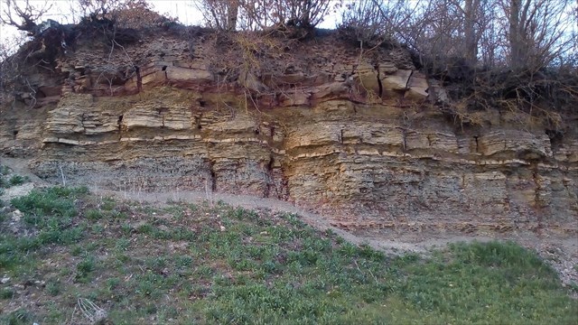
Abb.2 – Der Aufschluss / Fig.2 – The outcrop
Grabfeld-Formation
Ganz unten befinden sich ältere graue Estherienschichten (Benk-Formation) bestehend aus dünnplattigen, blau-grauen Tonsteinen, die durch Verwitterung auch gelblich bis ockerfarben erscheinen. Auffallend sind die „Zellenmergel“, an der Basis des Aufschlusses. Diese Tonsteinlagen sind kreuz und quer von Calcitbändern durchzogen.
Die Grabfeld-Formation (früher Gipskeuper) besteht im Heilbronner Raum aus einer bis zu 150 Meter mächtigen Abfolge von bunten Ton- und Dolomitgesteinen mit Lagen von Gips-Auslaugungsrückständen. Einzelne Bänke, wie die Bleiglanzbank, Malachitbank oder Anatinenbank, sind durch Farbe, Fossilführung und morphologische Ausprägung so auffällig, dass sie als Leit-Horizonte zur Untergliederung der monotonen Gesteinsfolge benutzt werden (Abb.3).
Bei der Ablagerung der Gesteine der Grabfeld-Formation waren die Bedingungen stark wechselhaft. Zum Teil übersalzene, flache Meeresräume wandelten sich im Lauf der Entstehung der Grabfeld-Formation zu nur periodisch überfluteten Trockengebieten. Die Fossilien führenden Gesteinsbänke verraten immer die relativ kurzfristigen Überflutungen mit frischem Meereswasser. Man findet Reste von Muscheln, kleinen Krebstieren, Fischen und vereinzelt von Meeressauriern. Ansonsten war die Zeit der Grabfeld-Formation jedoch ein lebensfeindlicher Abschnitt der Erdgeschichte.
2) Frage:
Im unteren Bereich des Aufschlusses fallen neben der grauen Farbe auch spezielle Strukturen auf, die ein bisschen an ein Netz erinnern. Worum handelt es sich? Wie viele Millimeter dick sind diese Strukturen und in welchem Abstand zueinander verlaufen sie?
Stuttgart-Formation
Die Stuttgart-Formation (früher Schilfsandstein) im obersten Teil der Mauer hebt sich in Farbe und Bankigkeit deutlich von den fein geschichteten Tonsteinen der darunter liegenden Grabfeld-Formation ab. In der Region Heilbronn ist die Stuttgart-Formation ein überwiegend feinkörniges, grünlich-gelbes bis rostbraun gefärbtes Gestein. Quarz, Feldspat, Glimmer und Schwermineralien sind die wichtigsten Bestandteile.
Die Stuttgart-Formation wird meist als Flussablagerung angesehen. Vor 225 Millionen Jahren, zur Zeit des Mittleren Keupers, gab es in Nord- und Nordosteuropa ein großes bergiges Festland, den Kontinent Fennosarmatia. Flüsse transportierten enorme Mengen an Verwitterungsgestein nach Südwesten und damit auch in das Gebiet um Heilbronn. Die heutigen kompakten Stuttgart-Formationsstränge in Nordost-Südwest-Richtung sind Überreste des in den Flussarmen abgelagerten Sandes. Die tonigen bis sandig-tonigen Schichten wurden in den sumpfigen Stilwasserlagunen zwischen den Flussarmen oder bei geringeren Wasserströmungen abgelagert.
Ältere Schichten wurden oft durch die Erosionskraft des fließenden Wassers ausgewaschen. Infolgedessen sind Sandsteinstränge teilweise tief in die geologisch ältere Grabfeld-Formation darunter eingeschnitten. Schräg-, Kreuz- und Strömungsrippelschichtung beweisen, dass die Stuttgart-Formation in fließendem Wasser abgelagert wurde. In der Stuttgart-Formation findet man Muscheln, Skelettteile von Reptilien wie z.B. Panzerlurchen und vor allem pflanzliche Fossilien. Beeindruckend sind die Überreste des bis zu sechs Meter hohen baumstarken Schachtelhalms (Equisetites), der damals weit verbreiteten Palmfarne sowie Nadelbäumen. Diese Flora gedieh in der Nähe eines seichten Gewässers oder in warmfeuchten Niederunden des Festlandes. Der frühere Name der Stuttgart-Formation war Schilfsandstein ("Schilfsandstein"). Er kann auf den fossilen Schachtelhalm zurückgeführt werden, der fälschlicherweise als Schilfhalme interpretiert wurde.
3) Frage:
Betrachtet man den Aufschluss von unten nach oben, ändert sich (abgesehen von einzelnen schmalen abgesetzten Bänken) zunächst die Farbe von blau-grau nach gelblich-ocker, dann ändert sich die Struktur von grob nach fein. Doch wo genau ist der Übergang von der Grabfeld-Formation zur Stuttgart-Formation? Bei der Farbänderung oder bei der Strukturänderung?
|
 English Description English Description
To grow wine, you need, apart from a sunny south-facing slope and a favourable climate, one thing above all: good soil. Which soil this is in the Heilbronn area and how it was created is what this earthcache is about.
There is no container hidden for this cache. To log it, you need to send us the answers to the three questions in the text below. You may then directly log a find. We will get in touch with you in case the answers are not correct.
We are happy about pictures, but this is of course purely voluntarily and in no way required to log a find.
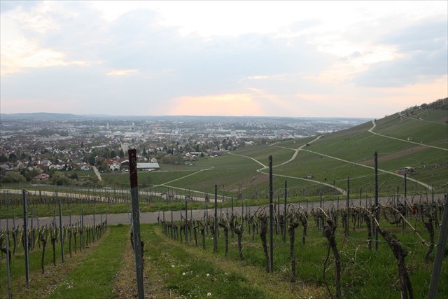
Abb.1 – Aussicht vom Wartberg / Fig.1 – View from the Wartberg
Rock in the Heilbronn Vineyards
Heilbronn is part of the Central European Basin (formerly the Germanic Basin). Its formation is traced back to the expansion of the Earth's crust in the Permian 299 to 252 million years ago. It then expanded to the south in the Triassic 252 to 200 million years ago. Characteristic of the Germanic Trias in southern Germany are the deposits of Buntsandstein ("Bunter sandstone"), then Muschelkalk ("mussel chalk") and then Keuper. While Keuper and Buntsandstein are mainland formed, Muschelkalk is based on a marine formation. The Triassic rocks, especially those of the Keuper period, are the most important witnesses of geological history in Heilbronn, along with ice age formations. The rock layers of the Middle Keuper surround the city east of the Neckar from the Wartberg in the north over the city forest at the Jägerhaus to the Staufenberg in the south.
The layers of the Keuper-mountains around Heilbronn are 235 to 200 million years old and up to 150 metres thick. The weathered marlstone on the slopes of the Wartberg, which mainly belongs to the Grabfeld Formation, with its blue-grey, green and red tones is ideal for viticulture. The Keuper marl arises from deposits of the rocks and is composed of clay and lime. It quickly breaks down in the air to soil, is air and water permeable, has a high nutrient content and is quickly warmed up by the sun - ideal conditions for successful viticulture.
A layer of up to 45 metres thick Stuttgart Formation, the Heilbronn sandstone, can be found atop of the Grabfeld Formation. It is not suitable for viticulture, but has been intensively mined in some places (see GC2Q3KJ). Its stones were built in a culturally and historically significant way at the town hall, Kilian's Church and at the main train station in Heilbronn, in Bad Wimpfen at the Red Tower, and sculptures at Heidelberg Castle and ornaments at Cologne Cathedral were made from it. This sandstone was created in the Middle Keuper 232 to 209 million years ago.
The soil at the foot of the Keuper-mountains, partly weathered to loess and rubble, dates from the last ice age around 30,000 years ago (see GC20EYN). Like the Keuper marl, it is a weathered soil that represents a wonderful basis for viticulture and produces the best plants.
1) Question:
At waypoint 1, one has a good view on the Wartberg and the other vineyards (Fig.1). Why do the vineyards in many places not extend to the top of the mountains, but have a forest atop of them? Use the geology of the mountains to justify your answer.
Outcrop at the "Rebstöckle" Viewpoint
At waypoint 2 you stand under the “Rebstöckle” viewpoint and you can easily see the outcrop there from the path (Fig.2). In its rock layers it shows the transition from the older Grabfeld Formation seen below to the younger Stuttgart Formation above.
Grabfeld Formation
At the very bottom are older gray layers of estheria (Benk Formation) made up of thin-plate, blue-grey clay stones that also appear yellowish to ocher-coloured due to weathering. The "cell marls" at the base of the outcrop are striking. These mudstone layers are criss-crossed with bands of calcite.
The Grabfeld Formation (formerly Gipskeuper) in the Heilbronn area consists of a sequence of colourful clay and dolomite stones up to 150 metres thick with layers of gypsum leaching residues. Individual benches, such as the galena bench, malachite bench or anatine bench, are so striking due to their colour, fossil record and morphological characteristics that they are used as marker horizons to subdivide the monotonous series of rocks (Fig.3).
When the rocks of the Grabfeld Formation were deposited, the conditions were very changeable. In the period of the Grabfeld Formation, partly oversalted, shallow sea areas were transformed into dry areas that were only periodically flooded. The rock banks containing fossils always reveal the relatively short-term flooding with fresh sea water. You can find remains of mussels, small crustaceans, fish and occasional marine dinosaurs. Otherwise, however, the period of the Grabfeld Formation was a section of earth's history that was hostile to life.
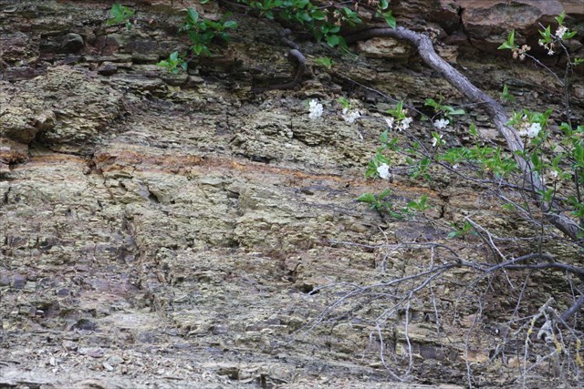
Abb.3 – Leit-Horizont / Fig.3 – Marker horizon
2) Question:
In the lower area of the outcrop, in addition to the grey colour, there are also special structures that are somewhat reminiscent of a net. What are they? How many millimetres thick are the structures and at what distance to each other do they run?
Stuttgart Formation
The Stuttgart Formation (formerly Schilfsandstein) in the uppermost part of the wall clearly stands out in colour and bank from the finely layered clay stones of the Grabfeld Formation below. In the Heilbronn area, the Stuttgart Formation is a predominantly fine-grained, greenish-yellow to rust-brown coloured rock. Quartz, feldspar, mica and heavy minerals are the most important ingredients.
The Stuttgart Formation is mostly viewed as a river deposit. 225 million years ago, at the time of the Middle Keuper, there was a large mountainous mainland area in northern and northeastern Europe, the continent of Fennosarmatia. The rivers transported enormous amounts of weathering debris to the southwest and thus also into the Heilbronn area. Today's compact Stuttgart Formation strands in northeast-southwest direction are remnants of the sands deposited in the river arms. The clayey to sandy-clayey layers were deposited in the swampy still water lagoons between the river arms or with lower water currents.
Older layers were often washed out by the erosive power of the flowing water. As a result, strands of sandstone are now partially cut deep into the geologically older Grabfeld Formation below. Inclined, cross and flow ripple stratification prove that the Stuttgart Formation was deposited in running water. In the Stuttgart Formation you can find shells, skeletal parts of reptiles, such as labyrinthodont, and, above all, vegetable fossils. Remains of the up to six meters high tree-strong horsetail (Equisetites), the cycads and conifers, which were widespread at the time, are remarkable. This flora thrived near a shallow body of water or in the warm and humid lowlands of the mainland. The former name of the Stuttgart Formation was Schilfsandstein ("reed sandstone"). It can be traced back to the fossil horsetail, which used to be mistakenly interpreted as reed stalks.
3) Question:
If you look at the outcrop from bottom to top and ignore the few narrow banks, the colour initially changes from blue-grey to yellowish-ocher, then the structure changes from coarse to fine. But where exactly is the transition from the Grabfeld Formation to the Stuttgart Formation? At the change of colour or the change of structure?
|