This earth cache does not require you to climb any rocks. It is a public observation point where you can see the coastline and answer the questions asked. You can also walk along the nearby shore (rock wall) and enjoy the beauty this area offers. Please use caution and be safe.
Rhode Island Coast

What is Rhode Island coastal erosion and why is this happening?
One of the smallest states is becoming smaller. Rhode Island shorelines are eroding and coastal properties and public infrastructure are becoming more and more vulnerable as the rate of sea level rise increases. The Rhode Island shoreline is naturally eroding and migrating over time. Much of the erosion occurs during short term storm events, which include both hurricanes and extra‐tropical Nor’easters.
While changing coastlines are completely natural, the loss of land area is not. Coastal areas are meant to be dynamic, and shift with the weather throughout the seasons. Nevertheless, factors like sea-level rise are intensifying this natural process, and not allowing the coast enough time to recover.
Geology of Rhode Island
Rhode Island is the only state in New England formed entirely atop basement rock from the microcontinent Avalonia. The bedrock of Rhode Island first took shape with the emergence of a volcanic arc near a subduction on the margin of the supercontinent Gondwana, with the earliest rocks likely formed in the late Neoproterozoic. The geology of Rhode Island is based on nearly one billion year old igneous crystalline basement rocks formed as part of the microcontinent Avalonia that collided with the supercontinent Gondwana. The region experienced substantial folding associated with its landlocked position during the Alleghanian orogeny mountain building event. The region accumulated sedimentary rocks, including small deposits of coal. The region was covered with thick Atlantic Coastal Plain sediments, with the erosion of the Appalachians and the creation of the Atlantic Ocean throughout the past 200 million years. These surficial sediments and soils were substantially reworked by the Pleistocene glaciations.

Narragansett Bay

Narragansett Bay is a ria, a drowned river valley that remains open to the sea. It consists of a series of flooded river valleys formed of dropped crustal blocks in a horst and graben system[4] that is slowly subsiding between a still-shifting fault system; however, the estuary system is vast compared to the present flow of the four small rivers that enter the Bay: in the northeast, the Taunton River and in the northwest, the Providence and Seekonk Rivers, along with the Pawtuxet River from the west.
What is a Ria?
A ria is a coastal inlet formed by the partial submergence of an unglaciated river valley. It is a drowned river valley that remains open to the sea. Typically, rias have a dendritic, treelike outline although they can be straight and without significant branches. This pattern is inherited from the dendritic drainage pattern of the flooded river valley. The drowning of river valleys along a stretch of coast and formation of rias results in an extremely irregular and indented coastline. Often, there are naturally-occurring islands, which are summits of partly submerged, preexisting hill peaks.
What is Erosion Control
Erosion control is the practice of preventing or controlling wind or water erosion in agriculture, land development, coastal areas, river banks and construction. Effective erosion controls handle surface runoff and are important techniques in preventing water pollution, soil loss, wildlife habitat loss and human property loss.
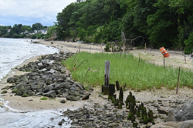
Pictured above is an erosion control method the Nature Conservancy and its partners installed called a living shoreline at Rose Larisa Memorial Park in East Providence to help keep coastal erosion at bay.
QUESTIONS/TASKS:
1. Observe the signs of erosion at the posted coordinates. Make your way to the stage two observation point and make the same observations. What are the differences in the erosion in both spots? What do you contribute these differences to?
2. At both locations tell us the time in between waves hitting the shore and explain to us the difference in the force of impact between the two locations. What is contributing to the difference?
3. To prove that you were here, please post a picture of yourself or your GPS with the river in the background. Any other photos of the area are also greatly appreciated.