Schloss Hohentübingen und die Württembergische Landesvermessung
English description below. Summary of the log conditions at the end.
Zusammenfassung der Logbedingungen am Ende der Cachebeschreibung.
DEUTSCH
Schloss Hohentübingen
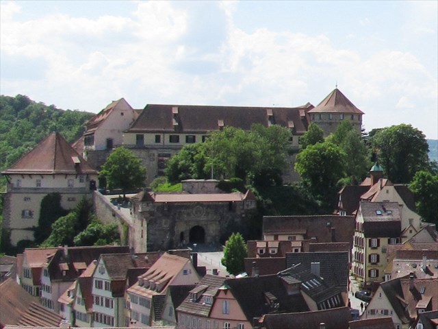
Das Schloss Hohentübingen stammt in seiner heutigen Form weitgehend aus dem 16. Jahrhundert, Vorgängerburgen sind seit dem 11. Jahrhundert belegt. Das Schloss ist nicht nur eine sehenswerte Burg mit schönen Aussichten und einem interessanten Museum, sondern auch ein Denkmal des Vermessungswesens: Hier, genau genommen am Nordostturm, liegt der Ausgangs- und Nullpunkt der 1818 begonnenen Landesvermessung des damaligen Königreichs Württemberg. Die württembergischen Koordinaten zeigen dabei mehrere Kuriositäten aufgrund von frühen Messfehlern. Das alles genauer zu beschreiben würde den Rahmen einer Cachebeschreibung sprengen, lest einfach hier weiter:
Württembergische Landesvermessung bei Wikipedia
... und beim Landesamt für Geoinformation und Landentwicklung
Schloss Hohentübingen bei Wikipedia
Unimuseum
Der Cache:
Um diesen virtuellen Cache zu loggen, müsst ihr zwei Fotos machen und an das Log anhängen: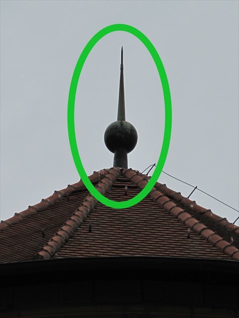
* Auf dem ersten Bild sollte der Nullpunkt selber zu sehen sein, also die Spitze des Nordostturms. Von wo dieses Bild aufgenommen wurde, spielt keine Rolle - es kann beispielsweise ein Bild des Turms vom Burggraben aus oder der Blick von irgendeinem anderen Punkt der Stadt, von dem aus der Nordostturm zu sehen ist, sein. Den Nullpunkt direkt zu besuchen kostet Eintritt, ist aber möglich: Im Turm befinden sich Ausstellungsräume des Universitätsmuseums, dort könnt ihr alternativ auch ein Foto der Mittelsäule machen.
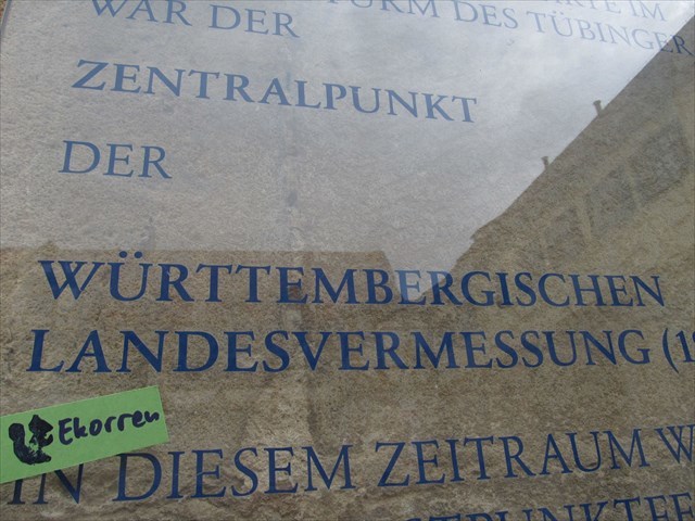 * Für das zweite Bild müsst ihr irgendwo auf dem Schlossgelände - zwischen dem unteren Tor und dem Schänzle am Hinterausgang - nach einer Infotafel suchen, auf der die Württembergische Landesvermessung erwähnt wird. Dort macht ihr ein Foto, auf dem das Wort "Landesvermessung" zusammen mit einem persönlichen Gegenstand, zum Beispiel einem Zettel mit eurem Cachernamen oder eurem GPS-Gerät, zu sehen ist. Es gibt mindestens fünf geeignete Infotafeln auf dem Schlossgelände.
Wenn ihr als Gruppe gemeinsam unterwegs seid und nur ein Teilnehmer die Fotos macht und hochlädt, muss dieser alle anderen beteiligten Cachernamen im Log erwähnen. Zusätzlich erwähnen bitte die anderen Teilnehmer auch, wer die Fotos hochgeladen hat.
Ich behalte mir ansonsten vor, Logs ohne Fotos oder mit falschen Fotos kommentarlos zu löschen.
Praktische Hinweise:
* Das Schlossgelände ist täglich von 7 bis 20 Uhr geöffnet. Außerhalb dieser Zeiten kann der Virtual nicht geloggt werden.
* Die Innenräume des Schlosses können - mit Ausnahme der Museumsräume - nicht besichtigt werden, da sie von der Universität genutzt werden.
* Öffentliche Toilette: im Schlosshof, Westflügel
* Eingeschränkte Barrierefreiheit: Der Zugang über die Burgsteige ist treppenfrei, aber sehr steil und holprig. Der Hintereingang vom Schänzle ist wegen Treppen für Fahrräder, Kinderwagen und Rollstühle ungeeignet.
* Keine öffentlichen Parkplätze in der Nähe! Parkt bitte außerhalb der Innenstadt, am besten zuhause.
ENGLISH
Castle Hohentübingen
Castle Hohentübingen ("Upper Tübingen") is a medieval castle known to have existed since the 11th century, with its current shape mostly originating from the 16th century. It isn't only a well-preserved castle with nice viewpoints and an interesting museum, but also a memorial of land survey in the 19th century: The northeastern edge tower marks point zero of the survey of the kingdom of Württemberg which started in 1818 and was completed in 1840. Searching recovery from errors made in the early stages of the survey the Württemberg coordinate system had some weird quirks - it's the only german system which is not based on sea level but on an own "level zero" at about 273m above sea level, also it used an own length unit slightly different from the standard. Unfortunately, I haven't found an english description I could link to, sorry. German links are in the german description above.
See also: English homepage of the University Museum
Log conditions:
To log this virtual cache you need to visit the castle and take two photos:
The first photo should show the point zero itself, taken from whatever point you can spot it from. Usually that would be a picture of the northeastern tower from the eastern moat (easiest), or maybe a view of the castle from the Stiftskirche church tower (like on the picture above). You may be able to find other suitable viewpoints. However, the pole on the tip of the tower must be visible.
The tower itself houses exhibition rooms of the University Museum where you can alternatively find and photograph point zero as a central pole (look in the ancient coins section, entrance fee applies).
For the second photo you need to find an information sign somewhere in the castle area which mentions the survey. Please take a photo of one of them which shows the word "Landesvermessung" or the english equivalent "land survey of Württemberg" together with some personal item, for example a piece of paper with your cacher name or your GPS device. There are at least five suitable signs on the castle, one of them in English.
Add both photos to your log.
If you visit the castle as a group of cachers and only one participant makes and uploads photos, this one must add a list of all participants in his or her log, and everyone else should mention the name of the one who uploaded the photos. Otherwise logs with no own photos may be considered incomplete and deleted without notice.
Practical information:
- The castle is accessible every day between 7 am and 8 pm. It is not possible to acquire the second photo after 8pm.
- There's a public toilet in the courtyard, western wing.
- Limited accessibilty with wheelchairs, strollers and bikes: The main entrance from the city centre side is free of steps but extremely steep and cobblestone plastered. The back entrance passes several stairs and is inaccessible on wheels.
- Parking: There are no public parking places available nearby. Please come on foot.
Deutsch - Zusammenfassung der Logbedingungen:
ZWEI Fotos machen und hochladen:
1. Der Nordostturm, Spitze muss zu sehen sein, Standort egal.
2. Das Wort "Landesvermessung" auf einer Infotafel auf dem Schlossgelände zusammen mit einem persönlichen Gegenstand.
English - Summary of log conditions:
Take TWO photos and add them to your log:
1. Northeastern tower, pole on the tip must be visible
2. The word "Landesvermessung" (or "land survey") on one of the informational plates in the castle, together with a personal item.
Virtual Rewards 3.0 - 2022-2023
This Virtual Cache is part of a limited release of Virtuals created between March 1, 2022 and March 1, 2023. Only 4,000 cache owners were given the opportunity to hide a Virtual Cache. Learn more about Virtual Rewards 3.0 on the Geocaching Blog.