The "Col d. Sommeiller" is located in the western alps (region Piemont, close to the city of Bardonecchia) and is the second highest point in the alps accessible by vehicle. It used to be the highest but was was suceeded by the Bontadini lift station near Breuil Cervina. Of course, there are a number of higher summits in the alps than C.d.S. or Bontadini, but these are only reachable on foot or (motor-)bike.
This cache is located in a former skiing area that was abandoned in the mid-80s when the glacier disappeared. The way to the summit is only poorly maintained. It is only once a year shortly before the "Stella Alpina", a bike meeting which takes place on the second Sunday in July, that the road is being cleared from snow and rocks. That´s the only time of the year where any maintenance takes place. Before that date, there is most probably too much snow in the higher regions of C.d.S. to reach the top anyway.
At the end of the trail you reach a plateau with a lake and the former summit house. Opposite this house is a hill with several flag posts on top (3050m). This is the "flag post hill". The actual summit can hardly be reached directly from CdS on foot as it is a cubble stone field which is dangerously steep. There is single trail in the south east of Punta Sommeiller which leads to the summit.
As far as we are concerned, it took two attempts to reach the top. In 2002 we had to stop halfways because there was too much snow. In 2003 we finally made it! It was wonderful up there and we are looking forward to lots of pictures form C.d.S. One of the reasons for this cache is to get detailed descriptions from the trail to the summit itself and the snow conditions during the year.
This is a "Virtual Cache" since the maintenance of a cache container at the C.d.S. is nearly impossible because of the terrain, the weather conditions and most of all the small time frame for a visit.
Prerequisites for a log of this cache:
- picture with the GPSr (and geocacher) on top of the flag post hill (see sample picture)
- picture of the GPSr showing recognizable and legible coordinates (+/- 50m) at the flag post hill (see sample picture)
- information about condition of the trail (snow height, other information maybe important for other visitors, the difficult parts, condition of the summit hill house, etc.)
- the way you reached the top (by foot, bicycle, motorbike, vehicle etc.)
- the visit must have taken place after february 18th, 2004 (date of approval of this cache)
Edit: 16.01.2005: Additional prerequisite to log this cache. As of today every log which is not written either in italien, french or english will be deleted without further notice.
The pictures are a clear prerequisite to log this cache. No exceptions made afterwards. If you don´t have a digital camera or cannot send me prints of the pictures, you should contact me first. Logs which don´t meet these requirements, will be deleted!
In case you couldn´t make it to the top, please do not hesitate to post a note. Describe at which passage and why you had to stop. In this case an altitude information would be terrific. This will help followers to better evaluate the situation at C.d.S.
Attention: Please read the following information carefully. And it is exactly meant this way.
This is not a paved road but difficult terrain. A 4WD Vehicle is indispensable. The trail is hardly maintained and you have to expect it to be interrupted and/or blocked by all kinds of material. You should have driven in difficult terrain before and be familiar with 4WD and your own vehicle.
Also, the snow and the general weather must be taken into account by all means. In general the summit can only be reached the earliest in late June / early July. This, of course, cannot be guaranteed as the weather conditions virtually may change "within minutes" and even in the summer there could be snow. Therefore, you should enquire the current conditions at C.d.S. at the "Rifugio Scarfiotti" and inform the landlords when you expect to be back. Furthermore don´t start too late and take the way back into account. The latter is especially important for trekkers and bikers. This area is high alpine terrain and you should have the appropriate gear and experience for such a trail.
Note for the flag post hill: the last part (100m) is difficult to reach by car. Therefore only attempt to drive up there with an appropriately modified offroad vehicle.
Note for the summit itself: The summit is located behind the flag post hill at the end of a cubble stone field. You cannot reach it with a car or (motor-)bike. You have to walk. Local trail maps show you the way.
If you have any question just send me an email.
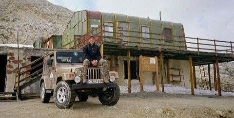
July 2003 - Me at Summit House / C.d.Sommeiller with "Golden Spike"
2017 road regulations for Colle Sommeiller
Brochure La Strada Del Sommeiller
Article about the summer skiing with some historic pictures