Many of those who come to the island of Tenerife for hiking stay in Puerto de la Cruz.
As a warm-up we propose a walk along the coast, starting at the old harbour. Stay always near to the sea: you will discover a well marked trail called "La Rambla de Castro". We strongly recommend to follow this path until the end ("Los Casones"), which is about 2 hours from Puerto. You will discover a beautiful unspoiled landscape with lots of endemic plants and palm-trees.
We refrained from hiding a physical cache in this area because it is a nature reserve. Thus you are kindly asked to stay on the paths and to follow the signs .... Note: The way down to the cache is not recommended by the authorities, but is completely unproblematic.
Once you get near the coordinates, keep in mind that you are not supposed to enter buildings nor to go further down to the beach (this part of the way is in extremely bad condition, there have been fatal accidents).
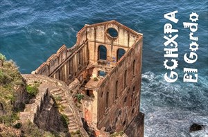
The site is around 100 years old. At this place the first steam-engine of Tenerife was used for pumping fresh water (from the gorge) upwards.
Those who continue their way to Los Casones should bring a torch and do the small detour via Playa de Fajana. The trail from there to Los Casones passes right through the rocks in an old "galeria" (tunnel).
Note on cache maintenance: GOTCHA does the maintenance
Eine Wegbeschreibung, im Web gefunden 2007:
ROUTE VON EL AGUA
Diese Route wird die von El Agua, des Wassers, genannt, weil sie alte Kanäle durchkreuzt und an Wasserquellen vorbei führt. Sie startet an den Appartements Acapulco, hinter dem Hotel Maritim. Sie verläuft auf der Felswand des Strandes von Los Roques, der so heißt, weil es da drei Felsen (Roques auf Spanisch) gibt (Grande, Chico und La Patita). In dieser Zone sind botanische Arten wie Nymphen-Dole, Balsam-Wolfsmilch, Kandelaber-Wolfsmilch und Kanarische Tamariske, sowie auch einige Kulturterrassen zu beobachten. Der Weg geht in der Siedlung Romántica II weiter, durch die Straßen Amapolas, Palmeras und Rosas. Wenn man die Abzweigung von Llanos de Méndez nimmt, kommt man zu dem Aussichtspunkt von El Campo Santo. Einige Minuten später ist man in La Romántica I, von wo aus man einen herrlichen Blick auf die Felswand und den Strand von La Fajana hat. Da ist auch der Wasseraufzug von Gordejuela zu erblicken. Über eine Treppe mit 320 Stufen kann man hinuntergelangen. Hinter dem Wasseraufzug von Gordejuela geht es etwas bergauf, und dann stößt man erneut auf den Weg, der nach La Rambla de Castro führt. Das ist ein Winkel der Küste von Los Realejos, der unter Naturschutz steht, und dort stehen außerdem zwei Bauten von großem historischem Interesse: Das Haus von den Castro und der Bunker von San Fernando.
El Gordo Banner
You are welcome to put the banner below (designed by Savage-Opress ) on your profile.
You may use the following HTML snippet:
<div style="text-align: center;"><a href="http://coord.info/GCHXPA"><img style="border: 0px solid ; width: 300px; height: 198px;"
alt="El Gordo" src="https://img.geocaching.com/cache/log/display/897d6815-a9ce-44c7-b839-b376d3088bfa.jpg"></a></div>