Question A
What do you see on the following picture:
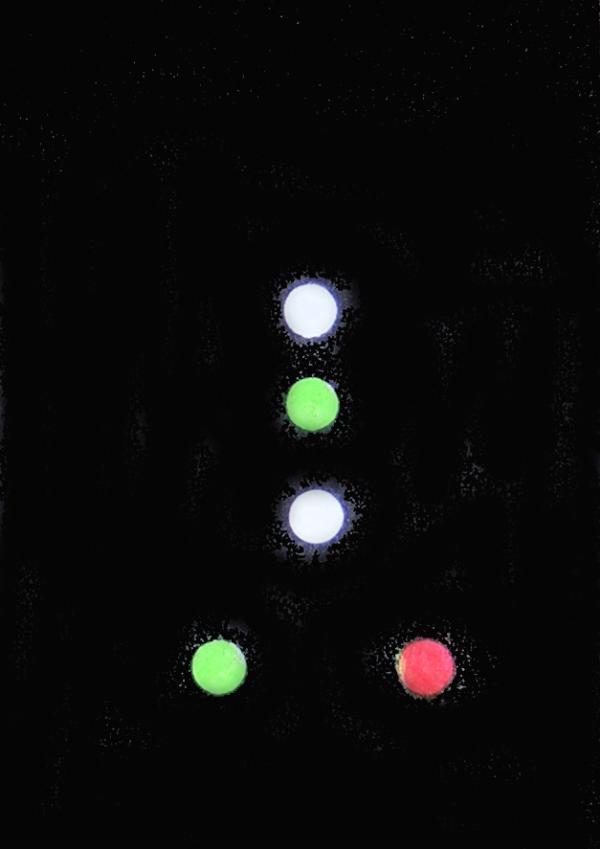
- the lights of a trawler longer than 50 meters, then A=052°
- the lights of a dredger restricted in its ability to manoeuvre, then A=106°
- the lights of a pilot vessel, then A=233°
- the lights of a hover craft, then A=349°
Question B
The old harbor of Dubrovnik is located at (WGS84):
- N 42°19.70', E 018°02.40', then B=088°
- N 42°24.60', E 018°10.30', then B=163°
- N 42°38.30', E 018°06.90', then B=215°
- N 42°43.50', E 018°17.80', then B=284°
Question C
The channel used for the DSC distress alert is:
- 16, then C=017°
- 55, then C=174°
- 70, then C=235°
- 83, then C=276°
Question D
The frequencies used for NAVTEX are:
- 480 and 508 kc/s, then D=0.048 nm
- 490 and 518 kc/s, then D=0.194 nm
- 500 and 528 kc/s, then D=0.236 nm
- 510 and 538 kc/s, then D=0.372 nm
Question E
The signal for a distress alert using the alphabetical flags is:
- Alfa and Golf, then E=5
- Charlie and Golf, then E=6
- November and Charlie, then E=7
- Quebec and November, then E=8
Question F
In a Croatian sea map, the letter "p" stands for:
- sand, then F=328°
- mud, then F=343°
- rocks, then F=358°
- sea weed, then F=013°
Before you start your search for the cache, be sure to use a magnetic compass,
do not try it with a geographic north!
Start your search at the position where you can take a bearing of "A"
to the tip of the tower of Ottensheim castle (see picture) and of "B"
to the southern edge of the Ottensheim lock and power station (see picture).
From here, walk in a "C" direction for "D" nautical miles.
After arriving at the number "E", walk in the direction of
"F" for about another 20 fathoms.
The cache (second edition: illy can) originally comprised:
- log book and pencil (please do not remove)
- shell from the Belgian Atlantic coast
- dwarf
- rubber ball
Happy hunting (or sailing),
BalkanSabranje