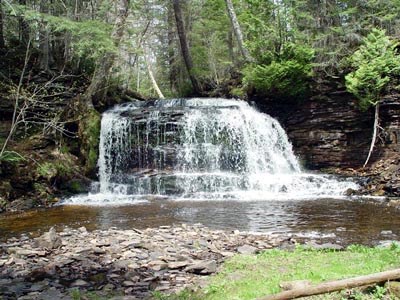
BDWF2 ROCK RIVER FALLS
Rock River Falls is on the Rock River: go figure. This is one of the most beautiful and secluded falls in Alger County. The height of the falls is about twenty feet. The trail into the falls slopes gently downhill for about one mile to the falls. The first half of the trail is an old road way: The second half of the trail is not as nice. The trail is unimproved and gets a little wet toward the lower end. I wore tennis shoes for the hike and didn’t get wet. This is a rather long hike with uneven footing in places. While you are in the area you may want to visit Silver Bell Falls on Nelson Creek.
Directions: From Chatham take HO1 (Rock River Road) north 3.2 miles. Turn left onto 2276 and follow 2276 for 3.6 miles. Turn left onto 2293 and follow 2293 for .6 of a mile. The small parking area and trailhead are on the left.
Cache: The cache is a 50 Cal ammo can.
Location Coordinates:
Parking: N 46* 25.386’ W 086*58.448’
Cache: N 46* 24.670’ W 086* 58.511’
Falls: N 46* 24.678’ W 086* 58.566’
We have seen lots of great waterfalls in Michigan's U.P. this year. You can see my waterfall picturs at: http://community.webshots.com/user/ronkelley