Diese Cacheserie soll wandernden Cachern die
Möglichkeit geben, neben dem Wandern auch noch dem Hobby
"Geo-Caching" nachzugehen. Aus diesem Grund werden im Laufe der
Zeit bis zu 147 Cache ausgelegt.
Die Cache sind von Nord nach Süd durchlaufend numeriert. Die Cache
sind Micros, Small, Regular oder Large.
Cacher, die sich an dieser Serie mit Auslegung eines Cache
beteiligen möchten, finden
hier weitere Informationen

Uebersicht aller bisherigen E1 Fernwanderwegscaches
=======================================================
Dieses ist Cache 138.
"Wutach-Kraftwerk"
Zunächst einmal dieser wichtige
Hinweis:
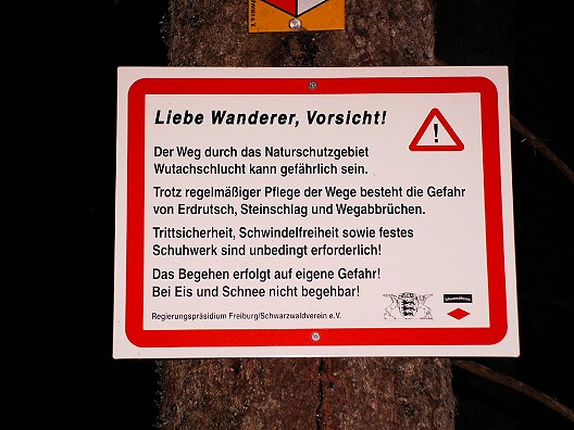
Die Strecke sollte man sich vorab auf einer geeigneten
Wanderkarte ansehen und eine Route planen, da man die
Schlucht nur an wenigen Stellen verlassen kann. Der Weg ist
nicht für kleine Kinder geeignet . Mit dem Fahrrad
oder Mountainbike ist dieser Weg nicht zu bewältigen.
Verhaltet Euch bitte umsichtig und nehmt Rücksicht auf die
Natur!
Für Tagesausflügler besteht die Möglichkeit, von der B31 an der
Abfahrt Neustadt-Mitte abzufahren und dann der Landstraße Richtung
Lenzkirch zu folgen. Hinter einer Eisenbahnbrücke nach links
abbiegen und einer Forststraße ca. 3km folgen. Dann das Auto am
Ende der Straße (an einer großen Freifläche, deren Sinn wir nicht
erkennen konnten)abstellen und der gelben Raute folgen, bis
schließlich der Weg nach links zum Zusammenfluß von Gutach und
Haslach abgeht. Bitte nehmt genügend Getränke und ggf. ein
Vesper mit. Insektenschutz ist unbedingt zu empfehlen, es
wimmelt dort vor Stechmücken.
Für die Hebung des Caches sind keine Klettertouren
erforderlich. Bitte wieder gut verstecken!
In der gesamten Schlucht ist das GPS-Signal dürftig bis überhaupt
nicht vorhanden, daher ist das
Spoiler-Bild möglicherweise hilfreicher als
obige Koordinaten.
English
This is one of 147 planned caches which are, or were, laid out by
different cachers along the European Long Distance Path E1. This
series of caches is meant to enable cachers to combine walking and
"geo caching". For this reason up to 147 Cache will laid out by and
by.
The caches are numbered consecutively from north to south. There
are micro, small, regular or large caches.
Cachers who would like to take an active part in this series by
laying out a cache themselves can find further information
here.
Description:
The path is in a protected area; before starting it should be
studied on a suitable walking map. Since the ravine can only be
left in few places, a route should be planned in advance. The
path can be dangerous, particularly when it is wet. Despite
regular care landslides and falling rocks are possible or
the path might stop apruptly. You should at any rate be
sure-footed and unafraid of heights; sensible
footwear is absolutely necessary. The path is not suitable
for small children. The path cannot be mastered by bicycle
or mountain bike. Please behave prudently and give
consideration to nature!
Day trippers can leave the B31 at Neustadt-Mitte and follow the
country road in the direction of Lenzkirch. Turn left behind a
railway bridge and follow a forest road for approx. 3 km. Park the
car at the end of the road (at a large open space with unknown
purpose) and follow the yellow lozenge until finally the path turns
left towards the confluence of the rivers Gutach and Haslach.
Please take sufficient beverages and possibly something to eat.
Insect protection is absolutely recommended - the place is swarming
with mosquitos!
Climbing is not necessary for elevating caches. Please hide
them again well!
In the entire ravine the GPS signal is poorly or not at all
present, therefore the
spoiler picture is possibly more helpful
than the above coordinates."