Unter Geiern
 Dieser Rätsel-Cache soll
Dich auf eine kleine Entdeckungsreise durch die Drôme
Provençale entführen. Für die Lösung werden ca. zwei Stunden
benötigt.
Dieser Rätsel-Cache soll
Dich auf eine kleine Entdeckungsreise durch die Drôme
Provençale entführen. Für die Lösung werden ca. zwei Stunden
benötigt.
Ein motorisiertes Fahrzeug ist zu empfehlen, da einige Kilometer
zurückgelegt werden. Hartgesottene können auch Ihr Glück mit dem
Fahrrad versuchen. Zu Fuß wird der Cache einen Tag in Anspruch
nehmen. Badesachen für eine anschließende Abkühlung mitnehmen!
Empfehlenswert ist außerdem ein Fernglas für die bessere Sicht auf
die Flora und Fauna. 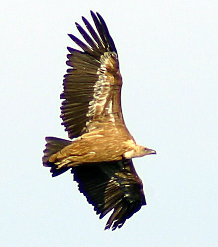
Vormittags ist die Tour fest in organisiert-touristischer Hand.
Mittags im Sommer brät man bei der Cachesuche unbarmherzig in der
Sonne – Getränke und Sonnenschutz nicht vergessen, sonst
endet man noch als unfreiwilliges Futter! Die beste Zeit ist der
sommerliche frühe Vor- oder späte Nachmittag ab 17:00 Uhr.
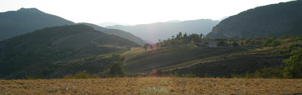
Nachmittags trifft man nur noch auf wenige zweibeinige Artgenossen,
die Sonne taucht die Gegend in ein angenehmes Licht, die Luft läßt
sich wieder atmen und die Geier ziehen Ihre Kreise.
Startpunkt ist die Maison des Vautours im Ort Rémuzat bei
N44°24.860, E5°21.386 Informiere Dich hier über die Tierart, die
diesem Cache den Namen gab und Karl May zu einem seiner Romantitel
inspirierte. Vor ein paar Jahren handelte sich der Dir
bevorstehende Ausflug noch um einen Geheimtip. Inzwischen gibt es
regelmäßig geführte Touren und morgens um 9:00 Uhr stehen vor dem
Schlachthof die Hobby-Ornithologen mit ihren Autos und warten auf
den Reiseführer.
Wenn Du den Fluß über die Brücke überquert hast, schaust Du bereits
auf den Ort, wo der Cache versteckt ist: der Rocher du
Caire. Jetzt mußt Du da nur noch hoch. Ein Wanderweg soll
angeblich in vier Stunden zu bewältigen sein – eine Richtung!
Verlasse Rémuzat in südlicher Richtung und folge der D94 vorbei
am Schlachthof. Als der Schlachthof noch genutzt wurde und die
Straße zwischen den Gebäuden hindurch führte (Ein interessantes
Studienobjekt französischer Straßenbaumentalität: jetzt führt die
Straße hinten herum; dort entlang, wo vorher die Rückwand der
Gebäude an den Fels gebaut war und per chirurgischen Eingriff
Architektur und Natur getrennt wurde. Die alte Straße ist zum
Firmengelände hinzugefügt worden.), wurden Schlachtabfälle an die
frisch angesiedelten Tiere verfüttert. Aus diesem und ähnlichen
Gründen ist das Baden flußabwärts ca. einen Kilometer verboten
– eine schöne Badestelle winkt zum Abschluß als Belohnung!
Inzwischen leben die Tiere aber scheinbar gut von den natürlichen
Ressourcen der Region.
Bei N44°25.131, E5°19.935 angekommen wirst Du feststellen, daß
die Straßenmeisterei zwar viele kleinere und große Parkplätze
angelegt hat, aber leider keinen mit Wasser zur Erfrischung. In der
Nähe gibt es aber eine Stelle, an der eine Quelle in einen von
einem Steinbogen geschützten Trog fließt. Es handelt sich zwar
nicht um ausgewiesenes Trinkwasser, doch ist es sehr erfrischend,
schmeckt gut und trotz wiederholtem Genuß sind keine Nebenwirkungen
bekannt. Eine gute Möglichkeit, die Trinkvorräte zu ergänzen und
auch gleich eine Aufgabe:
- Aus wie vielen Röhren tritt das Wasser aus dem Berg aus und
fließt in den Trog? Lösung = D
 Folge der Straße
durch die Gorges de St. May und genieße die
Landschaft. Nach kurzer Zeit kommt ein Tunnel.
Folge der Straße
durch die Gorges de St. May und genieße die
Landschaft. Nach kurzer Zeit kommt ein Tunnel.
- Beim Durchfahren zähle die Durchbrüche auf der rechten Seite,
durch die Licht einfällt. Die Anzahl merke Dir als E.
Du näherst Dich nun St. May. Fahre hinauf und parke an
der ausgewiesenen Stelle. Aufmerksamen Geocachern ist bei der
Auffahrt vermutlich schon der Wegweiser zum Rocher du Caire
aufgefallen. Zuerst gilt es aber die folgende Aufgabe zu lösen:
- Besuche den Friedhof; erweise den hier Ruhenden Deinen Respekt.
Der Torbogen wird von wie vielen Steinen gebildet? Zähle die Zahl
der Steine, die ausschließlich das Halbrund bilden und merke sie
Dir als F.
Alternativ kannst Du auch folgende Aufgabe lösen:
Monseigneur Paget, seines Zeichens Bischof von Valence, und seine
Helfer haben hier oben im April ein christliches Symbol erbaut und
auch geweiht. Bilde die Quersumme aller Zahlen und subtrahiere vom
Ergebnis (C+1). Das Ergebnis ist ebenfalls F.
Nun geht es endlich zum Rocher du Caire. Folge der Straße, die
etwas unterhalb vom bisheriger Parkplatz in St. May
abzweigt, und der Beschilderung bis zum Parkplatz. Bei N44°25.460,
E5°20.378 beginnt eine leicht ansteigende Schotterstraße, auf der
Du in ca. 20 Minuten zu Fuß den Aussichtspunkt erreichst. Auf dem
Weg gibt es noch ein Rätsel: 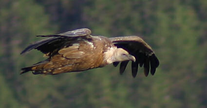
- Bei N44°25.302, E5°20.582 wächst wild eine wichtige Zutat für
die bekannten Herbes de Provence. Der Anfangsbuchstabe des
(französischen oder auch deutschen) Wortes steht an der wievielten
Stelle im Alphabet? Subtrahiere von diesem Wert B und merke Dir die
neue Zahl als G.
Alternative Aufgabe:
Bei N44°25.116, E5°20.873 wurde eine weitere Zutat für die
Gewürzmischung kultiviert. Eine gute Gewürzmischung kann man u. a.
daran erkennen, daß diese Zutat enthalten ist, was oft nicht der
Fall ist. Wieder mußt Du die Position des Anfangsbuchstabens
(französischer oder deutscher Name) im Alphabet ermitteln. Diese
Zahl ist ebenfalls G.
Bevor wir den Cache suchen, genießen wir die Aussicht und
fotografieren die Geier. Mal sehen, wer hier das beste Foto
veröffentlichen kann.
Um die Zielkoordinate des Cache zu ermitteln, wird etwas rechnen
nötig:
- N44°[C+E].[B+D-F][A][G-F-D]
- E5°[B+G].[E-D][F-A][C-F]
Der Cache soll ein Themencache sein, in dem ausschließlich
Motiv-Postkarten und Travelbugs getauscht werden. Also bitte
keine anderen Gegenstände traden!
Inhalt: Einige Postkarten aus der Region, Logbuch, Stifte.
Nach erfolgreicher Hebung des Cache darf im Sommer in der Eygues
gebadet werden. Eine schöne Möglichkeit bietet sich bei N44°25.995,
E5°18.608. Wer will, kann hier natürlich auch vor der Cachesuche
faulenzen und Energie tanken.
Viel Spaß bei der Suche und einen schönen Aufenthalt in der
pittoresken Region, die noch viele weitere potentielle
Cacheverstecke bereithält.
Parmi les vautours
Ce Cache énigmatique doit t'emmener à un petit voyage de découverte
à travers la Drôme Provençale. La solution prend environ
deux heures en voiture.
Un véhicule motorisé est recommandé, comme il y a bien de
kilomètres à faire. Les personnes endurcies peuvent tenter bonheur
en vélo. A pied le Cache prendra la durée d'une journée. Emmenez
vos maillots de bains pour vous refraîchir après! Des jumelles
seront bien utiles pour mieux observer la flore et la faune.
Le matin ce tour est beaucoup fréquenté par les touristes
organisés. En été à midi on se fait bien rôtir au soleil pendant la
recherche du Cache – pas oublier boissons et crème solaire,
autrement on finit comme nourriture involontaire! Le meilleur temps
est en été de bon matin ou l'après-midi après 17:00 heures.
L'après-midi on rencontre seulement peu de notre espèce à deux
jambes, le soleil trempe le paysage dans une lumière agréable,
l'air est bien à respirer et les vautours font leurs cercles.
Le départ est chez la Maison des Vautours dans le village
Rémuzat à N44°24.860, E5°21.386. Ici il faut prendre des
information sur l'animal qui donnait son nom à ce Cache et qui
inspirait Karl May en l'employant pour le titre d'un de ses romans.
Il n'y a que quelques années que cette excursion prévue était un
tip secret. En attendant ont lieu régulièrement des tours guidés et
à 9:00 heures le matin les hobby-ornithologues attendent le guide
devant l'abattoir.
Quand tu a traversé la rivière par le pont tu vois déjà l'endroit
où le Cache est caché: le Rocher du Caire. Maintenant il te
faut que monter. On dit que le chemin à pied prend 4 heures –
seulement l'aller!
En quittant Rémuzat suis la D94 en direction du sud devant
l'abattoir. Quand l'abattoir était encore en service et la rue
menait entre les bâtiments (Un objet d'études bien intéressant à
l'égard de la mentalité française concernant la construction des
routes: maintenant la rue mène par derrière, séparant architecture
et nature par une coupure chirurgicale là où était avant bâti la
paroi arrière contre le rocher. L'ancienne route est jointe au
terrain commercial.) on affourageait les déchets de l'abattoir aux
vautours nouvellement naturalisés. C'est pour ça et pour d'autres
raisons que la baignade est interdite jusqu'à 1 km en aval, mais à
la fin de l'excursion il y a comme récompense un beau endroit pour
se tremper. Il semble qu'aujourd-hui les animaux peuvent bien se
nourrir des ressources naturelles de la région.
Arrivé à N44°25.131, E5°19.935 tu vas remarquer que les ponts et
chaussées ont installé beau-coup de grands et petits parkings mais
aucun avec de l'eau pour se refraîchir. Pour cela il y a tout près
une source qui coule dans un bassin, protégé par un arc en pierre.
Ce n'est pas marqué qu'il s'agit de leau potable, mais elle est
très bonne et refraîchissante. Une consom- mation répétée n'a
effectué aucune réaction sécondaire. Une bonne occasion pour
complèter les provisions d'eau potable et en même temps pour un
autre devoir:
- C'est de combien de tuyaux que l'eau sort de la pente du rocher
coulant dans le bassin? Solution = D
Suis la route à travers les Gorges de St. May et
jouis du paysage. Sous peu il y a un tunnel.
- En traversant conte les échappées de vue qui laissent entrer la
lumière sur le côté droit. Note le nombre pour E.
Maintenant tu t'approches St. May. Monte au village et
gare la voiture au parking. Les geocacheurs attentifs ont
certainement vu déjà en montant le panneau pour le Rocher du Caire.
D'abord il faut faire le devoir suivant:
- Va au cimetière; honore ceux qui reposent ici . L'arc de la
porte est construit en pierres. Combien de pierres forment le
demi-cercle, bien entendu que le demi-cercle? Note leur nombre pour
F.
Devoir alternatif:
Monseigneur Paget, évêque de Valence, et ses aides ont construit et
béni ici en avril un symbole chrétien. Calcule la somme des
chiffres du nombre et soustrais du résul- tat (C+1). Le résultat
est également F.
Enfin on monte le Rocher du Caire. Au dessous du parking de
St. May suis l'embranchement de la route où des panneaux
te mènent jusqu'à un autre parking. A N44°25.460, E5°20.378
commence une route de cailloutis qui monte légèrement. Sur elle tu
gagnes le point de vue à pied dans environ 20 minutes. En chemin il
y a encore quelque chose à deviner:
Avant que nous cherchons le Cache nous jouissons de la belle vue et
nous prenons des fotos des vautours. On verra qui va publier ici la
meilleure.
Pour trouver les coordonnées il faut de l'arithmétique:
- N44°[C+E].[B+D-F][A][G-F-D]
- E5°[B+G].[E-D][F-A][C-F]
Ce Cache doit être un Cache thématique où on échange
exclusivement des cartes postales illustrées et des Travelbugs.
Ne pas échanger d'autres objets s'il vous plaît!
Contenu: Plusieurs cartes postales de la région, carnet de bord,
crayons.
Après la trouvaille du Cache, en été on a le droit d'une
baignade dans l'Eygues. Une bonne occasion se trouve à N44°25.995,
E5°18.608. Naturellement on peut paresser et regagner de l'énergie
ici déjà avant la recherche du Cache.
Amusez-vous bien à la recherche et au séjour dans cette région
pittoresque qui offre encore beaucoup d'autres cachettes
potentielles pour des Caches.
Under vultures
This puzzle-cache shall take you away to some short expedition
through the Drôme Provençale. To solve it, you’ll need
about two hours.
A motorized vehicle is recommended, as there are quite a few
kilometers to be covered. Hard-boiled can try their luck on a
bicycle as well. Finding the cache just walking will take a day.
Bring your swimming things for a following cooling! Recommendable
are also binoculars for a better view of flora and fauna.
In the forenoon, there are plenty of organized tourist groups
along the route. Around noon in the summertime, one is heartlessly
fried in the sun while searching for the cache - don’t forget
to bring your beverages and sunscreens, or you might end up being
involuntary fodder. The best time in summer is the early forenoon
or the late afternoon past 5:00 p.m. In the afternoon, you’ll
meet only a few two-legged conspecifics, the sun shrouds the
surroundings in a pleasant light, the air can be inhaled with ease
again and the vultures draw their circles.
Starting point is the Maison des Vautours in the town
Rémuzat at N44°24.860, E5°21.386. Get some information here
regarding the animal species which gave this cache its name and
which inspired Karl May to one of his book titles. A few years ago,
the excursion you’re about to go on was an insider tip.
Meanwhile, there are guided tours on a regular basis, and at 9:00
a.m. in the morning, tourist cars of the hobby ornithologists are
parked in front of the slaughterhouse awaiting the tour guide.
After crossing the river using the bridge, you’re already
catching sight of the location where the cache is hidden: the
Rocher du Caire. Now, you merely have to go up there. A
footpath can allegedly be gone up in four hours – one way!
Leave Rémuzat southward, follow the D94 and pass the
slaughterhouse. Back when the slaughterhouse was still in use and
the road went through between the buildings (an interesting object
to study the French mentality of road building: the road is now
redirected in the back, right where the back wall of the buildings
formerly used to be joined to the rock and where architecture and
nature were separated by man-made operations), the variety meats
were fed to newly settled animals. For this and similar reasons,
swimming downstream within a kilometer is prohibited – a
wonderful bathing place is in prospect for you at the end of the
tour as a recompense. In the meantime, the animals seem to make a
good living out of the resources in this region.
Having reached N44°25.131, E5°19.935, you’ll realize that
the road construction company indeed laid out many small and large
parking lots, but unfortunately none of them provides water for
refreshment. Nearby, however, there’s a place where spring
water runs into a trough sheltered by a stony arch. It’s not
specifically labeled as drinking water, yet it’s very
refreshing, tastes good and no side effects are known even after
repeated consumption. A good opportunity of stocking up with water
and solving a task right away:
- From how many pipes comes the water running down from the
mountain into the trough? Solution = D
Follow the road through the Gorges de St. May and enjoy
the countryside. After a short while, you’ll see a tunnel:
- When driving through it, count the breakthroughs on the
right-hand side from where the light comes in. Remember that number
as E.
You’re now approaching St. May. Drive upward and
park your car at the determined place. While driving up, observant
geocachers may already have noticed the signpost announcing
Rocher du Caire. Anyway, first of all, the following task
has to be solved:
- Go and see the cemetery, show some respect to those who rest in
peace here. How many stones have been used to built up the archway?
Count the number of stones that built up the semicircle exclusively
and remember it as F.
Alternatively, you can solve the following task too:
Monseigneur Paget, Bishop of Valence by profession, and his
assistants set up and also sanctified a Christian symbol up here in
April. Sum the digits of all numbers, and subtract from the result
(C+1). The outcome is F as well.
Now, let’s eventually go to the Rocher du Caire. Somewhat
downward the present parking lot in St. May, follow the
road fork and the sign to the next parking lot. At N44°25.460,
E5°20.378, there starts a slightly rising road with gravel surface
which you’ll have to walk along on foot for about 20 minutes
to reach the vantage point. While walking, here’s another
puzzle:
- At N44°25.302, E5°20.582, there wildly grows an essential
ingredient of the famous Herbes de Provence. At what
position in the alphabet is the initial letter of the (French or as
well English) word. From this value subtract B. Remember the new
value as G.
Alternative task:
At N44°25.116, E5°20.873, another ingredient of the mixed herbs was
cultivated. Among other things, a good mixture of herbs can be
recognized by containing this ingredient, which isn’t the
case that often. Once again, you need to determine its initial
letter’s position in the alphabet (French or English word).
The resulting number is G as well.
Before searching for the cache, enjoy the scenery and take some
photos of the vultures. Let’s see who’s going to
publish the best picture here.
To determine the coordinates of the cache’s destination,
some calculating will be necessary:
- N44°[C+E].[B+D-F][A][G-F-D]
- E5°[B+G].[E-D][F-A][C-F]
The cache is meant to be a thematic cache for exchanging picture
postcards and travelbugs only. So, please don’t trade
anything different!
Contents: Some regional picture postcards, a log, pencils.
After raising the cache successfully, you may go for a swim in
the Eygue in summer. There’s a wonderful opportunity to do
that at N44°25.995, E5°18.608. Of course, you can also hang around
here before searching for the cache and build up your energy.
Have fun searching and have a nice stay in that picturesque
region which still offers many more potential places to hide
further caches.
Weblinks: