Català
Sallent
és una població
amb molta
història,
situat a la comarca del
Bages.
Amb aquest
multicache
podreu
recórrer
alguns dels
indrets més
importants que conformen
els seus
orígens. El
important
poblat
ibèric del Cogulló
ocupat del S. VI al I
abans de C,
jaciment
d’uns 2.000 m2,
situat a 472
metres. El
seu castell
del S. XI, edificat
damunt del
congost on
hi ha el
poble. i
altres
monuments
romànics
importants,
com son
Sant
Pere
i
Sant
Martí de
Serraïma,
Sant
Miquel
de Serra-sanç, i la
bonica
església de
Santa
Maria
de
Cornet,
del segle XII.
Aquests
llocs abracen una bona part del
extens
terme municipal de
Sallent. Es
pot
enllaçar la
major part
del recorregut
seguint el PR-C133, i
puntualment el GR-4 i el
GR-4-3. El plànol
d’aquesta ruta
anomenada
Camí del
Romànic
és a
l’apartat
d’imatges.
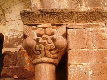
1-CASTELL DE
SALLENT
. [N 41º
49.084
E 001º 54.148]. Millor
accés des de
Sallent
pel GR-4-3
direcció a
Cabrianes
durant 1
km. aprox.
de quitrà,
fins a
l’entrada de la planta de
l’empresa
Potasas
del
Llobregat. Entrar a la
planta i seguir la pista forestal a ma
dreta. Valor de
[A]=nombre
de arcs
decoratius sota
teulada de
l’exterior del
absis central de
l’església de
Sant
Sebastià.
2-SANT MARTÍ
DE SERRAHIMA. [N 41º
49.735
E
001º55.872]
. Millor
accés des de
Sallent
pel PR-C133. Pista forestal.
Valor
de
[B]=suma dels
dígits de la data escrita
damunt la porta principal.
3-SANT PERE
DE SERRAHIMA. [N 41º
50.402
E 001º
55.167]
. Millor
accés des de
Sallent
pel GR-4-3. Pista forestal.
Valor de
[C]=suma
dels dígits
de la data escrita damunt la porta
principal.
4-SANT
MIQUEL DE SERRA-SANÇ.
[N 41º
50.705
E 001º
53.709]
. Millor
accés des de
Sallent
pel PR-C133. Pista forestal.
Valor de
[D]=nombre
de caràcters
alfabètics de la
inscripció que figura a
l’entrada principal.
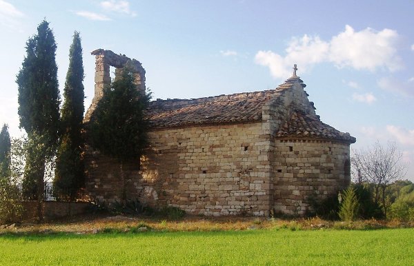
5-SANTA
MARIA DE CORNET. [N 41º
53.711
E 001ª
56.246]
. Millor
accés pel
km. 35 de la BP 4313, de
Balsareny a
Avinyó. Valor
de
[E]=número
repetit en les
hores del
rellotge de sol de la
façana.
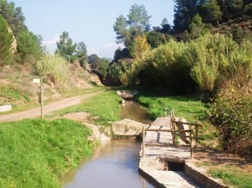
6-LA SÈQUIA.
[N 41º
48.203
E 001º
53.474]
. Millor
accés per
km. 60-61 de la C-16, sortida
Artés-Cabrianes-La
Botjosa, a 2 km. de
Sallent
direcció Manresa. Pista
forestal. Valor de
[F]=nombre
d’aqüeductes que figuren en el
plànol que
hi
trobareu.
Comprovació
A+B+C+D+E+F
= 80
Coordenades
finals: N
41º
48.[C-B][A/2][F]
E 001º
53.[D/E][E][C/D]
English
Sallent
is a town of the
Bages country. With this
multicache you can travel around some
more important historic places. The Cogulló is one important
iberic site, of the S. VI to I before
C, with 2.000 m2, at 472 meters. His castle of XI century is
building on top of the village. And another
romanic monuments like
Sant
Pere
and Sant
Martí de
Serrahima,
Sant
Miquel de
Serra-sanç, the beautiful church of
Santa Maria de
Cornet, of the XII century.
This
places across very part of
Sallent territory. Look the maps
of the paths PR-C133, GR-4, and GR-4-3 inside
of images section.
1-CASTLE OF
SALLENT. [N
41º
49.084
E 001º 54.148]. Best approach from
Sallent for GR-4-3
direction to Cabrianes through 1
km. of tarmac roughly, until entrance floor of the
Potasas
del
Llobregat Company. Inside in the
floor and take forest road to right. Value
of
[A]=number of decorative
archs under roof of the principal
pavilion of the church of Sant
Sebastià.
2-SANT MARTÍ
DE SERRAHIMA.
[N 41º
49.735
E 001º55.872].
Best approach
from Sallent for forest
road PR-C133. Value
of
[B]=amount the digits of the year
writing in the principal entrance.
3-SANT PERE
DE SERRAHIMA.
[N 41º
50.402
E 001º 55.167].
Best approach
from Sallent for forest
road GR-4-3. Value
of
[C]=amount the digits of the year
writing in the principal entrance.
4-SAN MIQUEL
DE SERRA-SANÇ.
[N 41º
50.705
E 001º 53.709]. Best approach from
Sallent for forest road
PR-C133.
Value
of
[D]=number of characters of the
inscription in the principal entrance.
5-SANTA
MARIA DE CORNET.
[N 41º
53.711
E 001ª 56.246].
Best approach for
km. 35 of BP 4313 road, between
Balsareny and
Avinyó. Value
of
[E]=hour
duplicate in the sundial of the façade.
6-THE DITCH. [N 41º
48.203
E 001º 53.474]. Best approach for km. 60-61 of the
C-16 road, exit to
Artés-Cabrianes-La Botjosa, at 2
km. of Sallent direction
Manresa. Value
of
[F]=number of aqueducts in the map that you
find.
Checking A+B+C+D+E+F =
80
Final
coordinates:
N
41º
48.[C-B][A/2][F]
E 001º
53.[D/E][E][C/D]