(Français ci-dessous)
This Cache was inspired by the Time/Speed/Distance (navigational) Car Rallies I participated in in the 1960’s and early ‘70s. Early TSD rallies required competitors to maintain precise average speeds to arrive at check-points at specific times. They lost points if they were early or late at a check-point. Timing was very tight, often to the second or hundredth of a minute. This frequently resulted in competitors travelling at excessive speeds to catch up after an off-course excursion or navigational error. As a safety measure, a variation on the above approach was developed in which timing is less critical and competitors are judged mainly on distance travelled – the winning entry is the team which completes the course with total mileage closest to the “official” distance as measured by the organizers.
This cache is based on the latter, safer, approach to Navigational rallying. The more precisely you measure the distances represented by the map, the easier your task to find the final cache. The objective is to follow the “Straight Line” map to a waypoint and then proceed to the Cache using information gathered along the way to establish the coordinates. (See instructions on how to read a Straight Line map below.)
The coordinates published above correspond to point “A” on the map - The stop sign at the exit of Dorval Shopping centre in front of the “Maxi” Supermarket. The map ends in a Cul-de-Sac at a large, multi-functional Recreational Park. Park your car (careful of the fire hydrant) and walk through the gate into the park.
Point “B” is a concrete column to your right in the north-east corner of the parking lot. The column is a special 3D Geographic Benchmark with highly precise and accurate coordinates which make it ideal to check the accuracy of your GPS unit.
The Cache is a fixed distance and Bearing from the Benchmark.
On top of the column is a metal plate inscribed with a series of numbers in the format: xxKxxxx
Multiply the first (2 digit) number by the second (4 digit) number, then subtract 5. Divide the result by 2.
This is the distance in metres to the Cache.
To find the True Bearing from the Benchmark to the Cache, take the difference (in metres) between the direct (as the crow flies) distance from points “A” & “B”, and the distance travelled according to the Straight Line Map from “A” to “B”. Divide the resulting number by 25 and add 333 . This is the true bearing to the Cache
Good Luck
For safety reasons, this cache should be tackled in the traditional manner of a car rally – with a two-person Driver/Navigator team.
Bring your own pencil
Français
Cette cache a été inspirée des rallyes automobiles Temps/Vitesse/Distance (de navigation) auquels j'ai participé durant les années 60 et 70.. Les premiers rallyes TVD exigeaient que les concurrents maintiennent des vitesses moyennes précises pour arriver aux points de contrôle aux instants spécifiques. Ils perdaient des points s'ils étaient en avance ou en retard à un point de contrôle. La synchronisation devait être très précise, souvent à la seconde ou au centième de minute près. Ceci a souvent eu comme conséquence de forcer les concurrents à atteindre des vitesses excessives afin de se rattrapper suite à un retard dû à une erreur de navigation. Comme mesure de sécurité, on a développé une variante à l'approche ci-dessus où la synchronisation est moins critique et où les concurrents sont jugés principalement sur la distance parcourue – l'équipe gagnante étant celle qui finit le parcours avec le kilomètrage total le plus près de la distance "officielle" telle que mesurée par les organisateurs.
Cette cache est basée sur cette dernière approche de rallyes de navigation, plus sécuritaire. Plus la mesure des distances représentées par la carte sera précise, plus il vous sera facile de trouver la cache finale. (voir les instructions sur la façon de lire une ligne droite sur carte ci-dessous.) L'objectif est de suivre la carte "ligne droite" vers un point donné et puis de se diriger vers la cache en utilisant l'information recueillie le long de la route afin d'établir les coordonnées.
Les coordonnées ci-dessus correspondent au point "A" sur la carte - le panneau d'arrêt à la sortie du centre commercial de Dorval devant le supermarché "Maxi" . La carte se termine dans un Cul-De-Sac dans un grand parc récréatif, multifonctionnel . Stationnez votre voiture (attention à la borne fontaine) et entrez dans le parc par la barrière.
Le point "B" est une colonne de béton sur la droite dans le coin nord-est du stationnement. La colonne est un repère 3D géographique spécial avec des coordonnées très précises ce qui la rendent idéale pour vérifier l'exactitude de votre unité GPS.
La cache se retrouve à une distance et à une position précise du repère. Sur la colonne se trouve une plaque en métal sur laquelle est inscrite une série de nombres dans le format : xxKxxxx. Multipliez le premier nombre de 2 chiffres par deuxième nombre de 4 chiffres, soustrayez 5, et divisez le résultat par 2.
C'est la distance en mètres de la cache.
Pour trouver la position précise du repère par rapport à la cachette, prenez la différence (en mètres) entre la distance directe (à vol d'oiseau) entre les points "A" et "B", et la distance entre "A" et "B" selon la carte “ligne droite”. Divisez le résultat par 25 et ajoutez 333. Ceci est la véritable position de la cache.
Bonne chance
Pour des raisons de sécurité, cette course se fera de la même façon qu'un rallye automobile - avec une équipe de deux personnes (conducteur/navigateur).
Apportez votre crayon
Straight Line Map / Carte en ligne droite

Instructions
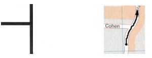
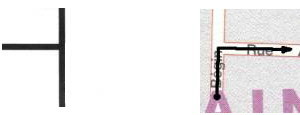
A straight line map is a simplified drawing of how a mapped route would look if it was a piece of string that was then pulled straight, with all of the connecting roads still attached. The straight line represents the road(s) being travelled at all times (although the actual route will not look anything like the diagram). To the left or right of the central line are “branches” which are instructions for what to do at each intersection. - Think in terms of instructions to "leave one / two road(s) on your left / right". If there are two connected lines, you will find a 4-way intersection. Otherwise, it must be a 3-way.
Une carte ligne droite est un schéma simplifié de ce à quoi une carte routière ressemblerait si c'était une corde qui aurait été tirée avec toutes les routes s'y connectant toujours jointes. La ligne droite représente le chemin parcouru en tout temps (bien que l'itinéraire réel ne ressemblera en rien au diagramme). À gauche ou à droite de la ligne centrale il y a des "branches" qui représentent les instructions à suivre à chaque intersection. Pensez en termes de directives:"laissez une/deux rue(s) sur votre gauche/droite". S'il y a deux lignes reliées, vous trouverez une intersection à 4 voies. Autrement, ce doit être un 3-voies
Examples / exemples:
Each point where the smaller lines connect to the main line corresponds to an intersection on the route. When you reach an intersection on the route the direction you take will depend on how that intersection is depicted on the map. If the actual intersection has a road going off to the left and the map shows the same thing, then you go straight on leaving the intersecting road on your left.
Chaque point où les lignes plus petites se relient à la ligne principale correspond à une intersection sur la route. Quand vous atteignez une intersection sur la carte, la direction vous prenez dépend de la façon dont cette intersection est représentée. Si à l'intersection, il y a une route vers la gauche et que la carte montre la même chose, alors vous allez tout droit en laissant une route sur votre gauche.
If, however, the actual road goes off to the right in the above example, you must turn right, effectively leaving the original road on your left.
Si, cependant, la route réelle va vers la droit, vous devez tourner à droit, en laissant effectivement la route originale sur votre gauche.
Another possibility
Une autre possibilité
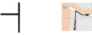
If the map shows two lines going off from the same point on the central line, the intersection is a “four way”. If the short lines are both on the same side of the central line, (in the form of a sideways “V”), you must turn the opposite way at the intersection (leaving two roads on the same side as the “V”).
Si la carte montre deux lignes allant du même point sur la ligne centrale, l'intersection est un "4-voies". Si les lignes courtes sont toutes deux du même côté de la ligne centrale, (sous forme de "V" latéral), vous devez tourner à l'opposé, à l'intersection (laissant deux routes du même côté que le "V").

If the lines go straight across the central line, you proceed straight through the intersection (leaving one road on each side.)
Si les lignes traversent la ligne centrale, vous continuez tout droit à l'intersection (laissant une route de chaque côté).

See also/voir aussi: http://www.torontoautosportclub.ca/articles/RallyMaster/106.html
Definition of “Road”
For the purposes of reading the above map, a road will be defined as:
