Allright all you geocachers out there who complain about micro scraps....park-n-grabs... number chasers... the 400 feet from the car finds....this is one where you're gonna have to put your money where your mouth is....
The Raccoon Loop at Raccoon Creek State Park.
Throughout your journey you will learn about many historical elements of the park. Including:
EARLY PIONEERS FRANKFORT MINERAL SPRINGS

CIVILIAN CONSERVATION CORPS RACCOON CREEK STATE PARK HISTORY


This cache will expire on 1/14/2017
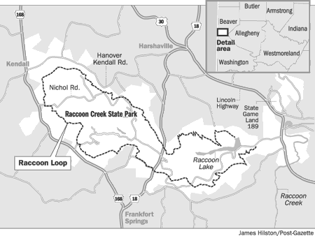
With the final touches of the Raccoon Loop originally put in place by some of our "pioneer" geocachers back in 2003, I'd like to bring, hopefully, some of them back to witness the newest part of the Loop....the Forest Trail Extension that eliminates the walk along Lakeshore Drive.
But why show someone only that part of the trail if they haven't hiked the rest of it? So.....
Although it's now officially measured at a little over 20 miles, by the time you look for all the cache stages, including those on other trails hidden near a historical element, you will have a mile or two more than that under your belt.
The Raccoon Loop is a combination of the Heritage, Appaloosa, and Forest Trails. But I'll also be taking you on the Wetlands Trail, the Heron trail, part of the Palomino trail, and a nice little nasty bushwhack off of the Camp Trail. Yee-Haw!
Sound interesting? Good. A few guidelines I've got to throw out there just in case:
- This cannot be tag teamed (i.e. I do stages 1-3, give coords to stage 4 to JoeSchmo and he does 4-7, back to me for 8-10, etc). Lame and defeats the purpose. If you don't want to hike the 20 miles, don't do this cache. The point of this multi is to get you to do the Raccoon Loop.
- Ultimately, I'd like this to be a single day cache, however, I realize the limits of endurance and time for many of us nowadays. If you split it up into a 2 or 3 day attack, the ratings would be an average of 2.5-star Difficulty and 3 or 3.5-star Terrain. So don't be scared off by the overall terrain rating, it's based on a single-day attack. I am only waypointing one set of official parking coords. If you want to break this down into a multi-day attack, parking spot #2 would be the Mineral Springs (N40*29.865 W80*25.664), parking spot #3 would be at a small pulloff on Hanover Kendall road (N40* 31.673 W80*27.100), and parking spot #4 would be at the Park Office (N 40*30.194 W 080*25.482). There are other spots to park, but that leaves you with roughly 5 miles of hiking between each parking spot. If you don't want to do it in one day, bring a buddy and 2 cars to coordinate parking spots.
- If you want to overnight, very nice backpacking lean-to shelters are availabe in the Sioux area off of the C6 connector or the Pioneer area off of the C5 connector. You will need to get permission from the park to overnight.
- If you don't do it in one day, I would appreciate it if you could post a note and let us know how much you've done so far, along with an approximate time it took you to do it.
Well, as a benchmark, I hiked this in a little under 8 hours a few years ago, 'course I was in a lot better shape then than I am now. When I dry-ran this recently during a 2-day stretch, it took me a little over 9 hours. I'm guesstimating with the time involved looking for the caches, reading the info, plugging in coords, etc., a minimum of 10 hours should be allotted to do this cache.
Now that I've got my anal-retentive speech out of the way, I would like to state that I am going to try and make the cache stages an enjoyable part of the hike, with little frustration in finding the various stages. How?
In the first cache stage, You will acquire a thumbnail picture of all hiding spots for all cache stages.
In each additional stage, the cache will contain 4 things:
- A brochure showing various history of the park.
- Coords to the next stage
- A hint for where the next stage is in the pictured object
- Partial coords for the final cache.
I am hoping this makes each stage relatively easily obtainable, but still interesting. Each stage, except one, won't be more than 300 feet off of a main trail, mostly within 100 feet. With the cache hide pictures and the hints provided at each stage, the difficulty rating is strictly for the length of the hike, not the caches themselves. Don't try and be a hero and not take the picture hint page in the first cache. I made the pictures sort of a twist on letterboxing....let's dub it "picture boxing"...and wasn't too worried about the coords. Some may be off as much as 40 feet based on what I saw when I was testing this cache. You have been warned. However, a DNF shouldn't be an issue if you use a little common sense and the pictures.
Hiking maps (You'll need both)
EASTERN MAP WESTERN MAP
*Note: The new Forest Trail Extension isn't listed on these maps. Follow the sign by the dam.*
** A special thanks to Pat Adams, who spent many hours helping me pull all of this together, as well as letting me have free reign over the filing cabinet treasure at the park. **
GOOD LUCK!
ADDED 4/7/2011 - STAGE 4 IS NOW UNDER THE TOP ROCK, NOT THE BOTTOM ONE.
ADDED 8/30/13 - I KNOW WHAT IT'S LIKE TO HIKE MANY MILES AND COME UP EMPTY. I DON'T WANT THAT TO HAPPEN ON THIS CACHE. I AM WILLING TO EMAIL YOU A COPY OF ALL THE CACHE STAGES PRIOR TO YOUR HIKE SO YOU CAN KEEP ON TRUCKING IF A STAGE GOES MIA. CONTACT ME IF YOU'RE READY TO HIKE 20 MILES FOR ONE SMILEY.
ADDED 4/5/15 - UPPER LAKE STAGE HAS BEEN MOVED ABOUT 3 FEET FROM PIC. BY FALLEN STUMP UNDER ROCK. SMALL LOC-N-LOC.