
 The main features of the Checkerboard Mesa are the generally perpendicular lines in the cliffs of the mesa. The vertical lines are shallow fractures likely resulting in repeated freezing and thawing of the rock surface. The roughly horizontal lines are the result of different rates of weathering along layers of coarser sand in the wind-blown (eolian) cross-beds of the Navajo Sandstone.
Cross-beds are formed by layers of sand grains as they build up into a dune then collapse. Wind piles sand up the gentle windward side of a dune. When the dune becomes too steep to support itself, it collapses creating the angled layers. This process also slowly inches the dune in the direction of the wind.
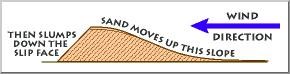 Over time, the next dune migrates over the first, burying the first and preserving the crossbeds. The USGS Western Coastal & Marine Geology website has some downloadable movies to demonstrate the process (http://walrus.wr.usgs.gov/seds/bedforms/animation.html).
Image Source USGS: http://www2.nature.nps.gov/geology/usgsnps/dune/dune.html
Logging requirements:
Send me a note with :
- The text "GCZ5Z9 Checkerboard Mesa - Zion NP" on the first line
- Based on the the crossbeds you can see, which way was the wind generally blowing when they were formed?
- Optional--because some are logging this from information from other sources, please post a picture of yourself or another in your group with the Checkerboard in the background.
As a note, this will be an apparent wind direction since the references I have indicate that the wind was generally blowing from the north to the south.
The above information was compiled from the following sources:
- Miek, Robert F., et. al., Geology of Zion National Park, Utah in Geology of Utah’s Parks and Monuments, 2003 Utah Geological Association Publication 28 (second edition) D.A. Sprinkel, T.C. Chidsey, Jr. and P.B. Anderson, editors
- USGS: http://www2.nature.nps.gov/geology/usgsnps/dune/dune.html
Placement approved by the
Zion National Park