 Parking for this earthcache is in a dirt
turnout at the corner of the roads. To reach the coordinates,
follow one of the dirt paths along the fence line toward the
hillside. Once on the hillside you are in an unmarked park
(Maps show the park, but there are no signs on the ground).
Follow one of the trails along the base of the hill remaining
below the boulder field and above the orchard road.
Parking for this earthcache is in a dirt
turnout at the corner of the roads. To reach the coordinates,
follow one of the dirt paths along the fence line toward the
hillside. Once on the hillside you are in an unmarked park
(Maps show the park, but there are no signs on the ground).
Follow one of the trails along the base of the hill remaining
below the boulder field and above the orchard road.
Some of the features you will see are Native American
archeological ruins and are protected under Federal Law. Do not
disturb the features in any way.
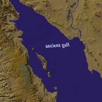 In the early Pliocene age (about 8 million years
ago), the Gulf of California extended northward up the entire
Salton Trough. The Salton Trough is rift valley, which means
that the valley is sinking as the land on either side of it is
pulled away from each other. Here at the Salton Trough, the
North American Plate on the east is moving away from the
Pacific Plate on the west. See the Salton Sea Geothermal Field for more.
In the early Pliocene age (about 8 million years
ago), the Gulf of California extended northward up the entire
Salton Trough. The Salton Trough is rift valley, which means
that the valley is sinking as the land on either side of it is
pulled away from each other. Here at the Salton Trough, the
North American Plate on the east is moving away from the
Pacific Plate on the west. See the Salton Sea Geothermal Field for more.
All images from Salton Sea Authority
Around this time, the Colorado River was eroding the Grand
Canyon and depositing the eroded material into the Gulf of
California. It continued building up a delta across the Gulf until
the delta spanned the entire width of the delta. As a result, the
ocean was blocked from filling in the Salton Trough as it continued
to sink. 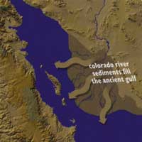 This delta is what makes the southern Imperial
Valley such a fertile farming region.
This delta is what makes the southern Imperial
Valley such a fertile farming region.
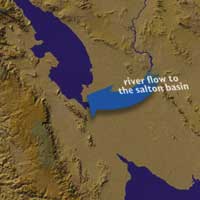
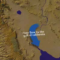
The Colorado River meandered across its delta, sometimes
draining south in to the Gulf of California and sometimes draining
northward into the Salton Trough. When it drained northward, it
filled up the Salton Trough with a massive freshwater lake. When
the Colorado redirected south again, the freshwater lake would
evaporate leaving an empty basin. While it may be impossible to
determine how many times this cycle repeated, there is a lot of
evidence it occurred many times. The most recent freshwater lake,
Lake Cahuilla (sometimes called Lake Leconte), appears to have
formed before the year 1200. This lake extended from near the
US-Mexico border about 100 miles northward to Indio. At its widest
point it was about 25 miles wide. It is estimated to have been more
than 300 feet deep. However, by the 16th century when the Spanish
began exploring the area, the lake was gone and the Spaniards only
found only Native American legends of the lake.
 Evidence of Lake Cahuilla's shoreline can be
found around the Salton Trough at about 40 feet above mean sea
level, although it can range from 25 to 50 feet due to the
previously mentioned plate movements. At you approach the
location you should be able to easily identify a horizontal
line a little way up the mountain marked by change in color.
This line is the ancient shoreline.
Evidence of Lake Cahuilla's shoreline can be
found around the Salton Trough at about 40 feet above mean sea
level, although it can range from 25 to 50 feet due to the
previously mentioned plate movements. At you approach the
location you should be able to easily identify a horizontal
line a little way up the mountain marked by change in color.
This line is the ancient shoreline.
Below this line a travertine deposits cover the bedrock.
Travertine, sometimes called tufa, is a freshwater lime deposit. It
is formed in waters that have a lot of calcium carbonate (what
makes up shells) and algae. The algae uses the carbon dioxide from
the calcium carbonate in photosynthesis leaving the lime.
 Evidence of Lake Cahuilla's gradual evaporation
can also be seen at the coordinates. In this case the evidence
comes from what archeologists have interpreted to be Native
American fish traps. These traps are roughly circular piles of
rocks that were built along the shore of the lake. Fish would
swim into the circle and have a hard time figuring out which
way to swim back out of them.
Evidence of Lake Cahuilla's gradual evaporation
can also be seen at the coordinates. In this case the evidence
comes from what archeologists have interpreted to be Native
American fish traps. These traps are roughly circular piles of
rocks that were built along the shore of the lake. Fish would
swim into the circle and have a hard time figuring out which
way to swim back out of them.
The coordinates bring you to a line of traps built along the
hillside at about the same elevation. If the archeologist's
interpretation of the rock piles are correct, the shoreline of the
lake would have been at this elevation at the time these traps were
used. As you can see these traps are below the high water mark
shown by the presence of travertine on the rocks.
A little investigation around the coordinates and you can find
other lines of traps at different elevations. The interpretation is
that as the lake level fell due to evaporation, another set of fish
traps would have to be made since the traps at the higher elevation
would no longer be in the water and would be useless as fish
traps.
Since Lake Cahuilla dried up, the Salton Trough remained a dry
basin, only occasionally filled with rainwater during exceptionally
heavy rains, until a human accident redirected the Colorado River
into the Trough. In 1905, heavy flow in the Colorado broke through
a canal system that had been used to irrigate the Imperial Valley.
The break in the canal was not able to be fixed for two years. In
that time the Salton Sea was formed.
While in the past, the lakes have evaporated away, the elevation
of the Salton Sea is relatively stable due to irrigation runoff
replacing what water evaporates away. This is also what continues
to increase the salinity of the Salton Sea. The runoff brings in
small quantities of dissolved salts. These salts remain as only
pure water evaporates away.
Logging requirements:
Send me a note with :
- The text "GCZ792 Lake Cahuilla" on the first line
- The number of people in your group.
- Without damaging or altering any of the rocks, send me the
thickness of the travertine on one of the rocks. (The travertine
has naturally broken off in some places exposing the
thickness)
- Send me the coordinates for a set of fish traps that are older
than the ones at the given coordinates and a younger set. Include
how you determined the relative age of the traps.
The above information was compiled from the
following sources:
- ANCIENT LAKE CAHUILLA, Geology of the Imperial
Valley, Eugene Singer,
http://home.att.net/~amcimages/singer.html
- The Salton Sea (Now You "Sea" It -- Now You Don't) by Richard
Busch (FGMS Member), Lithosphere (June 1995); Fallbrook Gem and
Mineral Society, Inc.; Fallbrook, CA
http://fgms.home.att.net/salton.htm
- Colorado River Delta Has Created Many Salton Seas; Copyright
2004 - Salton Sea Authority - La Quinta, California,
http://saltonsea.ca.gov/