Yoldiameren ranta, Jakomäki
Yoldiameri on saanut nimensä Yoldia arctica -simpukan mukaan.
Kylmässä ja suolaisessa vedessä viihtyvää simpukkaa on löydetty
Tukholman lähistöltä
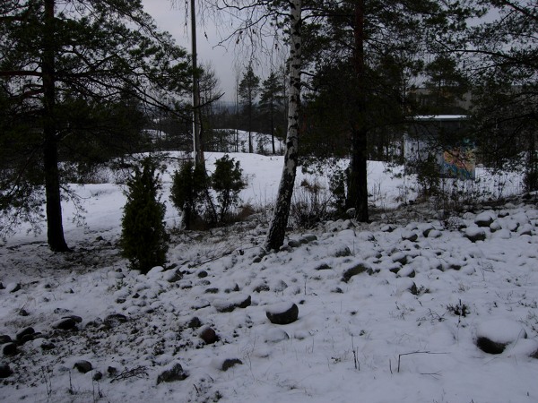
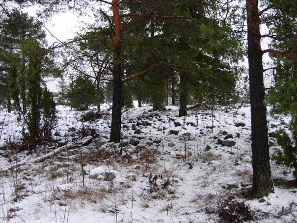
Kätköpaikka on Yoldiameren ranta Jakomäen huipulla. Ympärillä
näkyvät pyöreät kivet ovat tämän entisen pienehkön saaren
rantakiviä, 60 metrin korkeudella nykyisestä merenpinnasta.
Löytääksesi tämän kätkön suorita seuraavat tehtävät:
- Jos maassa on lunta yli kaksi senttimetriä, palaa asiaan
lämpimämmällä säällä, siis joskus tuonnempana.
- Lähesty kätköä etelästä, koordinaateista N60°15.429'
E025°04.419' käsin. ;lä kävele rantakivien läpi.
- Ota vähintään yksi kuva itsestäsi ja Yoldiameren rannasta.
Geologiset yksityiskohdat ovat tervetulleita muissa kuvissa.
- Arvioi rannan ja Yoldiameren saaren koko. Lähetä vastauksesi
profiililinkin kautta kätkön piilottajalle.
- Merkitse geokätkö löydetyksi ja liitä ottamasi valokuvat
maisemakätkön löytölokiisi.
![]()
Yoldia Sea, Jakomäki
The name of the sea is taken from the bivalve, Portlandia or
Yoldia arctica, found around Stockholm.
The hiding place is the shore of the Yoldia sea on the top of
the Jakomäki hill. The small round stones round the small island
are located 200 feet above the current sea level. To qualify this
cache as found you'll need to complete the following:
- If there is more than an inch snow on the ground, this cache
isn't foundable at all. When possible, do visit this site at a
warmer weather.
- Approach the cache site from the south, using the coordinates
N60°15.429' E025°04.419' along your way. Do not walk thru
the shoreline stones.
- Take a photo of yourself and the Yoldia sea shoreline. Also any
geological details are welcome in the other photographs.
- Estimate the size of the island and of the shore. Send your
answer thru the profile mail link to the cache hider.
- Log this geocache as found and attach all the related photos
along your entry.
|
Jääkauden jälkeinen Itämeri ja maan kohoaminen
Jääkerroksen painama maa nousi nopeasti, jopa 10 metriä sadassa
vuodessa. Yoldiameren suolaprosentti oli yksi, sillä sulava
jäätikkö lisäsi jatkuvasti makean veden määrää atlanttisen yhteyden
sulkeuduttua maannousun vuoksi. Vertailuna Itämeren nykyinen
suolaprosentti on 0.3-0.55 % ja maa nousee paikkakunnasta riippuen
30-90 cm vuosisadassa. Kuten varhemminkin, maannousu on edelleen
nopeinta siellä missä jäätikkö suli viimeisenä.
Baltic Sea and the Post-glacial rebound
The lands that were depressed by the ice sheets rose rapidly,
even as fast as 33 feet per century. The Yoldia sea salt level was
one percent since the melting ice added to the sweet water
constantly after the atlantic connection was closed due to the
post-glacial rebound. As an example the current Baltic Sea salt
level is 0.3-0.55% and the land is rising only 1-3 feet per
century. Like before, the rebound is more significant there where
the ice sheet melted last.