Dolly Sods is located west of Petersburg, WV in the Monongahela National Forest on the high plateau of Allegheny Mountain. The plateau is wind-swept and boggy. Elevations are from 2600 to over 4000 feet. The plant life and climate resembles northern Canada. Patches of native red spruce, alder, maple, and mountain ash mingle with plantations of pine, upland heath, and sphagnum bogs. The area is generally open, with wide-spreading vistas. Huckleberries and cranberries are common in the heath and bog areas.
History
The Dolly Sods area remained impenetrable until the late 1800s, when West Virginia's timber resources began to be exploited. As the logged areas were burned to create grazing areas, the open fields became known as "Sods." Unfortunately, the drying peat-like soil easily burned, leaving areas devoid of top soil.
The US Government began to purchase land in the area in the 1910s, and in the '30s the Civilian Conservation Corps planted pine to reforest the area. In 1943, the Army use the area for artillary and mortar practice for troops being sent to Europe to fight in World War II.
Warning: Many of the artillery and mortar shells shot into the area for practice still exist here. If you find an artillery shell, DO NOT pick it up. Make a notation on a map, showing location, landmarks, and distance to nearest trailhead - anything helpful - and call 1-888-283-0303 or contact the Petersburg office of the Monongahela National Forest.
For those planning to camp, please camp at existing campsites whenever possible. These usually have a fire ring and show bare ground around them. If you camp at a place without a fire ring DO NOT create one. If at all possible, do not go around small obstacles in the trail. Going around will encourage others to establish a new trail - one that hasn’t been cleared for unexploded artillary shells.
Area Details
Wildlife in the area includes black bear, whitetail deer, wild turkey, grouse, snowshoe hare, cottontail rabbit, bobcat, and a variety of rodents. Snakes, such as garter, grass, and ring necked, are common, and timber rattlesnakes also inhabit the area.
Weather can be severe, and heavy snow can make roads impassible in the winter. A 4-wheel drive vehicle with high clearance is recommended on the Forest Roads. The area is heavily visited by hunters during hunting season. Backpackers/hikers traveling during this season should wear blaze orange or brightly colored clothes. Campfires are not appreciated or welcome. The USFS encourages you to follow the "Leave No Trace" ethic when you visit this heavily used backcountry area.
Dolly Sods Wilderness has 25 miles of trails, many of which follow old railroad grades and logging roads. The National Forest and West Virginia Highlands Conservancy websites have great descriptions of the trail system.
Directions
From Petersburg, take WV 28/55 south. One mile past Smoke Hole Caverns, look for the brown Forest Service sign pointing to the right-hand turn to the Wilderness area onto State Road 4. Follow the paved road steeply up a fold in the hills. At the first "S" turn in the road, look for the turn off for FS 19 on your left. It is signed and easily located. This will give you access to the southern part of the Wilderness area at it's intersection with FS 75.
If you bypass the FS 19 turn off and continue on State Road 4, you'll arrive at the second access into the Wilderness at FS 75 after roughly 7 miles. The turn off is to your left with a church on the corner. This will give you access to the northern part of the Wilderness.
Important Note
Gates on Forest Roads 19 and 75, leading to Dolly Sods, will be closed during the winter months. These roads are closed to motor vehicle use from January to early April every year to provide for public safety due to highly variable road conditions in the winter months.
Claiming the Cache
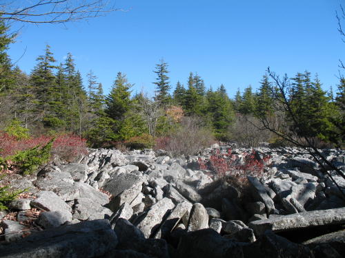
The Allegheny Front is a high cliff winding along the Dolly Sods Scenic Route. The front marks the boundary between the ridge and valley area to the east and the Allegheny Plateau to the west. Because underlying rock strata are not as erosion-resistant, different erosion patterns occur. This rock forms coarse, sandy soil that drains easily.
To claim this cache, walk the 1/3 mile Northland Loop Trail at the posted coordinates off of Forest Road 75. One of the signs on the trail describes the type of exposed rock seen throughout the area. Send me an email naming the type of rock (mikemcan@yahoo.com).