Beach Migration at Hammonasset Beach
Quick Description. The beach is a dynamic environment. It
is constantly changing. The natural forces of change on the beach
are waves, wind, and locally, tidal currents. In recent
times,humans have also caused changes, sometimes drastic, to the
beach. This Earthcache explores the natural changes that
continually shape and reshape the beaches at Hammonasset Beach
State Park.
This Earthcache is best if done in the late
spring before the park crews groom the beaches, possibly
replenishing (adding) sand to the beach. Plan your starting time to
be about a half hour before scheduled low tide. We did the
fieldwork in mid-April at the end of the winter storm season in the
northeast.
Purpose: This EarthCache is published by the Connecticut
Geological and Natural History Survey of the Department of
Environmental Protection. It is one in a series of EarthCache sites
designed to promote an understanding of the geological and
biological wealth of the State of Connecticut.
Supplies: You will need a copy of this login to answer
the questions once on site and be able to take a few photos on
site. Spoilers may be included in the descriptions or links.
Directions: Off I-95 north, Exit 62. Take a right off the
exit and go approximately 1 mile. Go straight through the traffic
light crossing Route 1 (Boston Post Road) into the park.
Fees: Hammonasset Beach State Park is open year round but
has an entrance fee May through the Fall. For more information go
to:
http://www.ct.gov/dep/cwp/view.asp?
Location: N41o 16.033’, W072o
34.008’
Date Listed:
Waymark Code:
Listed by: CTGEOSURVEY
Long Description. A beach is composed of sand or gravel
that accumulates along a shoreline. The composition of a beach
depends upon what is available for the waves and currents
(including the wind) to move. In south Florida the beaches are
composed of remains of corals, shells, and algae that live in the
immediate environment. Most are broken into sand-sized grains. In
Texas and western Louisiana the beaches are composed of grains of
sand brought to the coast by the Mississippi River. In most of New
England, beaches are composed of sand and gravel that was brought
to the beach by glaciers and/or glacial melt-water streams and
also, to a lesser extent, by wave erosion of bedrock exposed at
local headlands. In addition, most beaches have various sized and
shaped grains contributed by the many different organisms that
secrete calcium carbonate shells. Unfortunately, most beaches also
contain increasing amounts of trash.
Once sand reaches the beach environment it is moved by the wind
and water. Wind- generated waves, especially those waves generated
by large storms, are the most powerful agent that acts on the beach
particles. Wind blows the surface of the water into mounds, called
waves, which move in the direction toward which the wind blows.
Stronger winds produce larger waves. When water depth shallows just
off shore from the beach the waves build up and break onto the
shore, rushing up the beach (we call that the swash) and then
backwashing back to the sea. Probably everyone has noticed this and
knows that sand and gravel particles on the beach are moved up the
beach face by the swash and back down to the sea with the backwash.
Larger waves can move larger particles and larger volumes of
particles. That is why beach erosion is generally noticed after
large storms pass. Waves move the sand offshore, onshore and
laterally along the shore.
Storm waves generally are associated with strong undertows. This
has the effect of moving the sand from the recreational beach into
deeper water off shore. The sand piles up forming offshore sand
bars. You have probably noticed these when you have gone swimming
at many beaches. During calmer conditions, the offshore bars
migrate back and
 ;
;
weld themselves onto the recreational beach. You may have
noticed during the spring and early summer that there is less sand
on some beaches and they are steep and narrow. Then at the end of
the summer and early fall, the beaches are wider again. During
winter storms the sand migrates offshore and actually protects the
beach by causing waves to break and expend some of their power
farther away from the beach. The waves that reach the beach are
less powerful. The process of building the beach back up is called
swash-bar accretion.
In some places along many beaches there are low spots in the
beach berm or in the dunes behind the beach. When the waves get
large enough they wash through the low spots and into the lower
ground behind, usually a marshy area. When sand gets deposited
behind the beach it does not wash back onto the beach. Sand moving
from the front of the beach to behind the beach causes the beach to
migrate inland. Wind may also blow beach sand back into the marsh
with the same result. Beach migration looks like beach erosion only
when there is some permanent reference point, such as shore front
development. Otherwise, one might not notice any long-term
differences from just looking at a beach from year to year. There
would be seasonal differences for sure but all within the natural
variability of the beach. But if you have an immovable structure on
the beach you have trouble and call it beach erosion.
Sand and gravel on the beach also move along the shore face.
This is caused by waves that do not hit the beach head-on. If waves
strike the beach at some angle they do not swash straight up the
beach but rather swash diagonally up the beach at an angle that is
roughly parallel to the direction in which the wave travels. When
the wave backwashes, however, it returns to the sea directly, which
is usually perpendicular to the shoreline. Thus a sand grain is
carried diagonally up the beach face by the swash but backwashed
straight down the beach and ends up a few feet down the beach from
where it started. Millions of sand grains moving with each wave can
cause enormous amounts of sand to move along the shore. We refer to
this process as longshore drift or littoral drift.
The wind also moves sand along the beach or onshore and into the
marsh behind the beach. Wind-power is not as great as water-power
and the wind usually only moves smaller (finer-grained) sand
particles. The most noticeable wind deposits are the dunes on top
of and behind the beach. These dunes are almost always
fine-grained
Activity 1. Find your way to the above location in the
western part of Hammonasset Beach (N41o
16.033¢, E072o 34.008¢ ). That should
place you at a gap in the sand dunes through which campers have
access to the beach. It is also near the western end of the
boardwalk and near a concession stand. A path heads westward behind
the dunes from the concession stand. Walk along the path until you
come to N41 o 16.097¢, W072 o
34.196¢ (you will see a jetty were the tidal creek
enters Long Island Sound). Stay on the path. Stay off the dunes.
Stay out of the marsh grass. But notice the marsh mud and peat.
Peat is the organic accumulation composed of roots and rhizomes of
the marsh grasses (mostly Spartina sp.). It is a foot or
more in thickness. The roots and rhizomes hold the peat together
and protect it to some degree from erosion by currents in the tidal
creek.
Notice also that steep sided piles of fine-grained sand have
accumulated just inland from the low spots in the dune field. That
sand was derived from the beach face and blown inland by westerly
(fair-weather) winds. You will get onto the beach a little later on
this walk. Notice (and remember) what the size of the sand grains
are here to compare with the size of sand grains on the beach.
Question 1. What is the difference between beach sand and the
wind-blown sand. Is there any wind-blown sand along the beach? If
so, where is it?
Return to the starting point along the beach. Note that the
upper part of the beach is finer grained than the surf zone and
contains layers of pink to maroon sand. The maroon sand is composed
of abundant grains of the mineral garnet, some of it very clear and
gem-quality (except for its small size). The garnet is concentrated
because it has a higher density than most of the sand grains on the
beach, such as quartz and feldspar. That makes garnet heavier than
quartz and feldspar. The lighter quartz and feldspar are more
easily blown away than the garnet and the garnet gets left behind.
We refer to that as a placer (the “a” has the sound of the “a” in
plastic rather than sounding like the “a” in place) deposit.
Look at the low tide line an your way back and try to find a
layer like that pictured
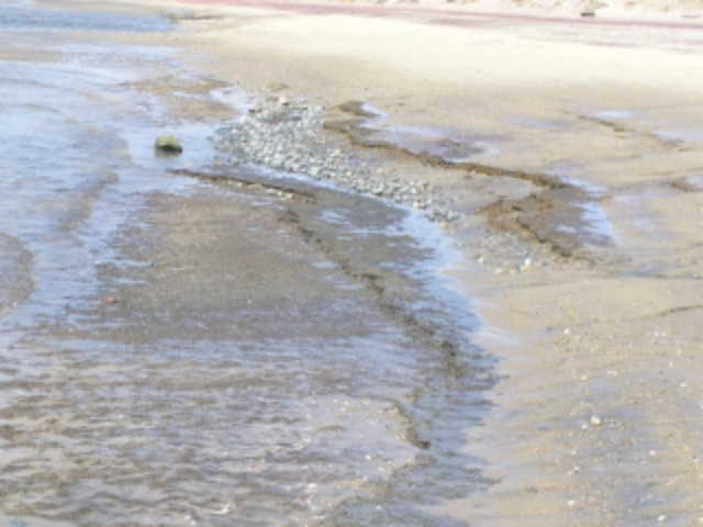

above. If you are too late in the season more sand may have
moved on shore and covered the layer. Notice the roots and rhizomes
and the color. It looks very much like the marsh mud and peat!
But what is it doing here on the beach face? We leave that for
you to answer as Question 2. (Hint: this is direct evidence for
shore-ward migration of the beach.)
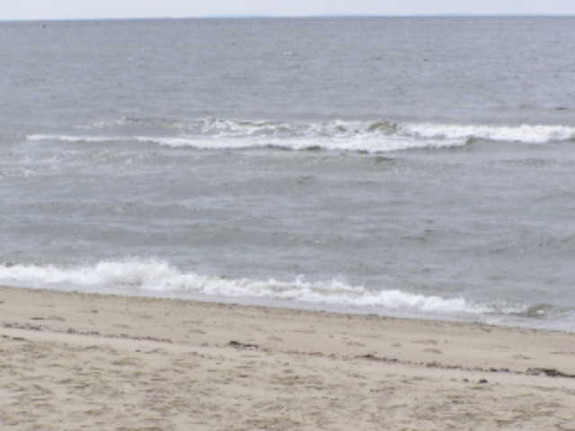
As you walk along the beach notice areas where the waves break
slightly off shore (see pictures). This indicates a shallow area or
an offshore bar. The bars, we refer to them as swash-bars, migrate
toward the shore during calm weather and you may see one or more
right up against the shore. It is likely that those are in the
process of accreting onto the shore, making the beach wider.
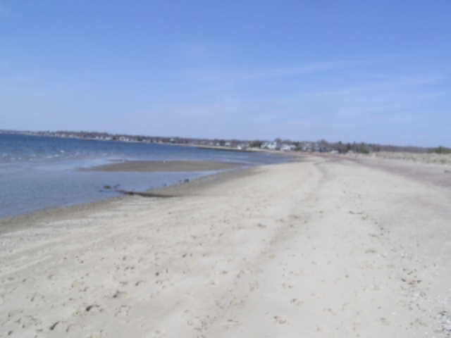
Activity 2. Find the following location (
N41o15.011’, W072o32.508’ ). It’s a
good hike (1.5+ miles one way) to the new location and you may wish
to take your car or a bicycle. A trail heads east from the parking
lot through the moraine boulders (see Why Are There Boulders at
Meigs Point Earthcache) to a spot where the beach is up
against the marsh (a low spot in the moraine). The upper part
(above the normal high tide line) of the beach here consists of
coarse grains of sand and gravel pebbles along with abundant
lady-slipper shells. Note that in the surf zone there is very
little sand. The size of the rocks in the surf-zone is too large
for most waves to move. Perhaps the largest storms can move them,
but there are not many in the deposits of the upper beach so no
such storms have occurred here recently. Notice that the sand and
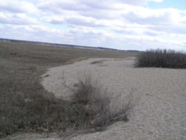 gravel is being washed onto the marsh by
storm-tide waves (see picture above). We call this a wash-over fan.
This is evidence for beach migration, although here we do not think
it has been that much. Can you find any marsh mud on the beach
face? We did not notice any, but we did not walk out onto the beach
to look.
gravel is being washed onto the marsh by
storm-tide waves (see picture above). We call this a wash-over fan.
This is evidence for beach migration, although here we do not think
it has been that much. Can you find any marsh mud on the beach
face? We did not notice any, but we did not walk out onto the beach
to look.
Question 3. Toward the end of April, 2007 a strong nor’easter
lashed coastal New England with gale force winds. This kicked up
waves that were about 5’ along the shore of central Long Island
Sound and 5-10’ in the eastern reaches of the Sound. More
nor’easters or maybe a hurricane will impact the coast in
succeeding years. By comparing the picture on this Earthcache with
what you see, can you document migration of the wash-over fan into
the marsh caused by all the storms since we took our picture? How
much did it move? Were cobbles moved onto the wash-over fan?
Additonal Information and References:
This EarthCache uses the format presented by Orrin Pilkey in his
documentary “The Beaches are Moving”, broadcast more than 20 years
ago by PBS. We applied his method to this beach in Connecticut.
The interested cacher can find more information in an excellent
book written by Peter Patton of Wesleyan University and James Kent,
1992, A Moveable Shore, the Fate of the Connecticut Coast.
Duke University Press, Durham, N.C., 43p. Although it is out
of print, many local libraries have copies.
How do people log this Earthcache? People will need to
provide answers to the Earthcache activity questions and
submit an image Difficulty: 1
Terrain: 1: Short walks for activity 1 are along the
beach and less than 0.5 mi (one way) are over mostly level ground.
The walk for activity 2 may traverse some cobble fields. Activities
1-2.
Type of land: State Park
Earthcache category: Beach dynamics -coastal feature.