The Rock Elm
Disturbance

As this
is an EarthCache, there is NO container. To claim this as a find
you will need to complete the tasks outlined below. Failure to
complete the tasks may result in the deletion of your log without
notice. The terrain is mostly a flat, well groomed trail until you
reach the rock formations where the terrain gets a bit uneven. Be
sure to grab a trail map and head for the "underlook." The park
entrance is located at N44 41.645 W092 13.280. There is a $5
per car daily fee but seniors (65 and older) are
free.
Impact-
While there is some debate, mounting evidence appears to show that
this area was struck by a 600 to 700 foot meteorite. Fossil study
revealed that this event likely took place during the Ordovician
Period, roughly 430 million to 455 million years ago when what is
now Wisconsin was located just north of the Equator. To give you an
idea how long ago this was, Wisconsin’s Ice Age ended 10,000
years ago and the Super Continent “Pangaea” broke up
230 million years ago...at the time of the impact the first
vertebrates (fish) were still emerging and plants were about to
appear on land.
It has been
estimated that the meteorite would have been traveling at
approximately 67,500 miles per hour. At ground zero the explosive
force of the impact could have been more than 1,000 megatons (or
about the energy equivalent in 63,000 Hiroshima size bombs). This
is a force strong enough to have lifted debris more than 1,650 feet
into the air and send crushing shock waves through the
rocks.
An
impact of this size comes along about once every 100 million years.
Worldwide, there are only about 200 such impact formations known,
and only a few dozen in the United States. In Wisconsin, the Rock
Elm Disturbance (impact crater) is the largest of three known
sites. The other two are near Pepin, on the Mississippi River in
west-central Wisconsin, and Glovers Bluff in the central part of
the state.
Crater -
The impact dislodged rocks and created a hole four miles across and
up to 1,000 yards deep. Today it is difficult to spot surface
features without a guide as the crater has eroded over time and
been filled by shale, dirt and sediment. Adding to the process of
erosion and also likely minimizing the initial crater size was the
fact that a shallow sea existed here at the time of the
impact.
Evidence
-
Since the 1930's differences in the geology of this area have been
documented. It wasn't until many years later that detailed studies
would begin. In the 1980's UW-River Falls Geology Professor Bill
Cordua began to look more seriously at the area. He started writing
about the formation in 1985, and although he suspected it was
formed by a meteorite, he could not yet prove it.
The rock structures
outside of the Rock Elm disturbance are typical for the area.
Layers of flat-lying sedimentary rocks can be seen where the rocks
are exposed to the surface. At the base of the sedimentary section
at lake level is a layer of sandstone called the Jordan Formation.
Over the Jordan Formation is a layer of a gray bluff-forming series
of dolostone, limestone and sandstone called the Prairie du Chien
Group. Both the Jordan Formation and Prairie du Chien Group were
deposited when a shallow sea covered the Midwest 480-500 million
years ago.
At the Rock Elm
disturbance, this area's normally stable geology abruptly changes.
Some bedrock is suddenly gone, dropped down, folded or faulted.
Sections of older bedrock consisting mostly of shale have been
uplifted 100's of feet to the surface. Younger sedimentary rocks
unlike any found elsewhere in the region were deposited in the bowl
of the disturbance. This may be a result of the disturbance bowl
being filled by new sediment from the shallow sea.
|
|
|
This image depicts a typical
impact crater. Breccias are one sign that an impact event such as
an asteroid or comet struck the Earth. Breccias can be seen at Rock
Elm. Also seen above is the central uplift and crater
rim.
|
In the center of
the disturbance is an area of uplifted bedrock. This "central
uplift" exposes greatly tilted beds of Mt. Simon sandstone, a
formation usually found in flat layers 700 feet below the surface
in this area. It is not uncommon for central uplifts to form in the
middle of large meteor craters. When the Earth is pushed down so
quickly some of it will have a tendency to spring back up thus
forming the central uplift.
|
|
|
A drop of water acts in much
the same way as a meteor strike creating a “central
uplift”.
|
Fragments within
the breccia include granite, other igneous rocks, metamorphic
quartzite and amphibolite, as well as sedimentary chert and
sandstone. Some sandstone fragments found here are enclosed by
glassy material, which could have been formed by melting due to an
impact from an extraterrestrial body such as a large meteorite.
Microscopic studies by Dr. Bevan M. French, Department of Mineral
Sciences, Smithsonian Institution revealed fine fracture patterns
in quartz grains like those known from shock metamorphism, giving
greater weight to the extraterrestrial impact theory. Similar
anomalous areas of deformed and faulted early Ordovician dolomite
are present near Glover Bluff.
The coordinates listed for this EarthCache will bring you
to a "U" shaped rock formation. Along the way to this location you
will pass the coordinates for requirement # 1 below. You may park
on the mowed grassy area near the trail-head located at N44
41.528 W092 13.477. While permission has been granted to park
here, if the area is wet or muddy please park in a designated lot
instead.
LOGGING
REQUIREMENTS:
(Your log may be deleted if you do not follow these logging
requirements)
1.
Identify and E-MAIL me the colorful name of the rock
formation listed at this coordinate N44 41.557 W092
13.574.
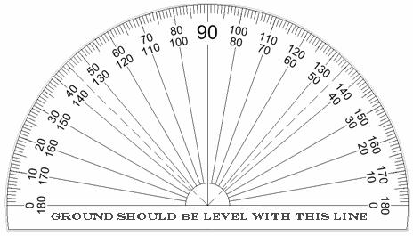
2.
At the primary listed coordinates for this EarthCache (N44 41.546
W092 13.581) there is a "U" shaped rock formation. Measure the
angle on each side of the "U" and E-MAIL me what the
greatest angle is on each side. For this task you may bring along a
protractor or use the one below.
*Remember- Do not post the answers for any of the
requirements in your online log; answers must be E-mailed to
me.
Uploading photos of the
rock formation found at ground zero is the best way to say thank
you to the cache developer and to encourage others to visit the
site.
Permission for this cache has
been granted by Park Manager Scott Schoepp.
Special thanks to Zuma! for cache intel and to Dr. William S.
Cordua, Professor of Geology/Mineralogy, University of Wisconsin -
River Falls for his assistance with this EarthCache.
References:
http://physics.uwstout.edu/geo/asteroid_local.htm
http://www.seagrant.wisc.edu/MadisonJASON/Default.aspx?tabid=1468
http://www.uwrf.edu/news_bureau/0913022.html
Dr. William S. Cordua, Professor of Geology/Mineralogy, University
of Wisconsin - River Falls