The Changing Beach at Bushy Point
Part I
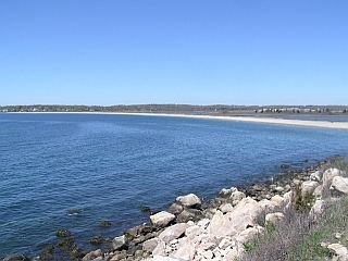
Crescent shaped Bluff Point-Bushy Point beach is about one
mile long. It extends from the Bluff Point headland, from
where this picture was taken, to Bushy Point, which is just off the
left side of the picture. Bushy Point is an island at high
tide. A lagoon may be seen behind the beach on the right side
of the picture and the Poquonock River estuary is behind the beach
in the center part of the picture (it can not be seen behind the
dunes on the left side of the picture).
Short description. Change always occurs on beaches
because of what they are and the physical processes that take place
there. Beaches are accumulations of granular material (sand
and gravel) along the shore of a body of water. Granular
material is easily moved by the power of moving water and wind in
the shoreline environment, thus changing the beach. Sand and
gravel may be removed (erosion) from one place and deposited in
some other place. Weather and tides cause the natural changes
that occur. The larger the body of water the more rapidly the
changes can occur. This Earthcache explores the natural
processes that occur on the east end of the Bushy Point-Bluff Point
beaches and some of the changes that have occurred
there. A companion EarthCache explores the changes that have
occurred along the west end of the beach. A separate
EarthCache explores the geology of Bluff Point.
Bluff Point State Park and Coastal Preserve is a great place to
spend a morning or afternoon or the entire day because there is so
much to see and do. It is an undeveloped state park with a
bumpy access road and limited facilities (rest facilities are found
at the parking area and at the end of the trail near the
bluff). There are hiking and biking trails galore, none very
strenuous and some relatively smooth allowing for family biking and
access for those with ambulatory difficulties. It is a
long hike however…just over a mile one-way. In addition,
the beach is over a mile long. Be sure to bring water, and
expect to carry your trash out with you.
Purpose: This EarthCache is published by the
Connecticut Geological and Natural History Survey of the Department
of Environmental Protection. It is one in a series of
EarthCache sites designed to promote an understanding of the
geological and biological wealth of the State of Connecticut.
Location: Bluff Point State Park and Coastal
Preserve, Groton,
CT
N41o20.156, - 072o02.023’
Date Listed: PARKING LOT
Waymark Code:
Listed by: CTGEOSURVEY
Directions: From I-95: Take
exit 88. Turn south (left if coming from I-95 north; right if
coming from I-95 south) onto SR 117 South. Turn right at
the end onto Route 1 South. Take a left at the first light
onto Depot Road. The drive into the park is under the
rail-road tracks after the residential area. Park entrance is
at the left side of the parking area at the end of a rather bumpy
drive.
Long Description: This beach is composed of loose sand
and gravel that is constantly on the move. Mainly physical
forces act upon the loose sediment and move it along the
shoreline. For instance, sand in the swash zone is
moved by each wave; sand higher on the beach face is moved only
during storms and exceptionally high tides; sand in the dunes
behind the beach is moved when the wind is strong enough and the
sand is dry enough.
Beaches can be thought of in terms of supply and demand.
Supply is the amount of loose material available to form the
beach. This material may be glacial till or outwash that is
sitting around, it may be material brought to the system by rivers
or shoreline currents, or it may be material that is created by
erosion of bedrock cliffs along the shore. “Demand” is
created by the physical conditions that together combine to move
the loose materials around. When there is more material
available than the currents can move away, the beach will build
up. When currents are capable of moving more material than is
available, the beach will erode.
Most of the processes for which we will see evidence involve
moving air or water. Many physical processes occur on a daily
basis with minimal effect on the beach. For instance, the
wind blows most of the time at the shore, but winds strong enough
to blow the beach sand around occur only once every few days.
Winds strong enough to move large quantities of sand occur less
frequently. Likewise, waves occur constantly and if you
watch, each wave moves sand back and forth. Over weeks,
gentle waves may gradually move sand onto the beach, but usually
these changes are not noticeable on a daily basis. However, a
good storm may move tons of sand away from the beach in a matter of
hours, and it is very noticeable.
On your walk down the beach, keep track of several things.
Of what is the beach composed and what is its texture? Of
course, the beach is made-up of granular material. But of
what are the granules composed. Also, what size is that
material and how does it change along the beach?
Activity 1. Find N 41o18.961’,
- 072o02.189’ (near bluff). This should put
you on the beach face near where the beach is attached to Bluff
Point. Is there much sand on the beach? If you look
back toward the bluff you will notice many boulders that have
fallen off the bluff and accumulated at its base. Some are
very large but notice that they become progressively smaller closer
to the beach and there are no boulders on the
beach. Also, the smaller boulders and cobbles tend to have their
angular edges worn to smooth rounded edges. Compare the
boulders to the material on the beach at this

Boulders of granite and granite gneiss that have accumulated
at base of bluff. Largest boulder in picture is about 2 ft.
in length; some boulders, however, are 4-6 ft. in
length. Notice the angular edges on these boulders.
Rock has a flesh-pink color because it is composed of a large
amount of potassium feldspar, which has that color. White areas of
the rock contain an abundance of sodium-feldspar.
location. The gravel fragments are all rounded and
relatively smooth. This results from the waves moving the
particles back and forth in the surf zone. As they move the
particles hit each other causing corners, edges, and small
asperities to break off, leaving a smoother surface. Notice
that only about 10% of the gravel particles are composed of
pinkish-colored feldspar or pink-granite. Most of the
material that forms the beach is derived glacial materials rather
than erosion of the bluff.
The action of waves. Water parcels move in a
circular motion during the passage of a wave. A given parcel
of water moves forward when the crest (top) of the wave passes, it
moves downward as the wave moves away, it moves backward when the
trough (low area on the water surface) of the wave passes and it
moves upward as the next wave approaches. The circular motion
dies out with depth below the surface. In shallow water, the
passage of a wave on the water surface affects the sediments on the
sea-bottom with a forward-and-back movement. The back and
forth motion stirs up the bottom sediment, suspending the tiniest
(mud-sized) particles. The process is called winnowing.
The fine material (mud) settles out in quiet, usually deeper water
elsewhere. Because of winnowing action of the waves, the
above and below water part of the beach is composed of sand and
gravel without mud.
When the wave hits the shore it breaks. Easy-to-see sand
movement occurs with each breaking wave and its backwash.
When the wave breaks water rushes shoreward (swash) and carries
sand grains with it. When the swash slows down, the sand
grains stop moving (that is, they are deposited). Eventually
the forward motion of the wave stops and water begins washing back
down the beach. As the water backwashes its velocity
increases and soon begins washing the sand grains back to the
breaker-zone. During some conditions each wave may leave a
little sand at the highest point of its upward swash and build-up a
high-tide berm. A berm may remain until the next tidal cycle
moves it higher. Several berms may be visible on this part of
the beach. They were deposited by storm waves or during
higher tides.
|
|
|
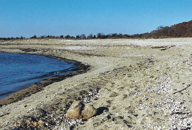
Left. Picture taken during Fall of 1999 near location
of Activity 1. Note there are few cobbles and no boulders on
the beach. The beach is made up of gravel-sized particles of
rounded gray rocks and minerals along with hundreds of lady-slipper
shells. Notice multiple berms: the lowest berm was formed by
the last high tide. Higher berms are probably the result of
storm tides.
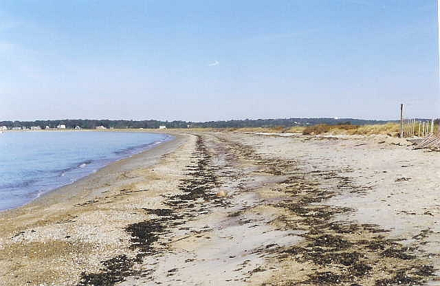
Right. Multiple berms farther down the beach near
Activity 3 taken during the Summer of 2001. Lowest berm (on
left) formed during last tidal cycle. Berm in center is
slightly higher and formed during a higher tide or perhaps during a
minor storm. Note dunes, highest part of beach, on right and
a slight erosional scarp at their base. The scarp formed
during a major storm, probably during the winter or spring of
2001. Wrack-line is linear pile of debris, mostly sea-weed,
that marks the highest level that waves reached during the
particular tide that formed the berm.
During a storm stronger winds blow the waves into larger
forms. Storm waves generally are associated with strong
undertows. This has the effect of moving the sand from the
recreational beach into deeper water off shore. The sand
piles up forming offshore sand bars. You have probably
noticed these when you have gone swimming at some beaches.
During calmer conditions, the offshore bars migrate back and weld
themselves onto the recreational beach. You may have noticed
during the spring and early summer that there is less sand on some
beaches and they are steep and narrow. Then at the end of the
summer and early fall, the beaches are wider again. During
winter storms the sand migrates offshore and actually protects the
beach by causing waves to break and expend some of their energy
offshore and away from the beach. The waves that reach the
beach are less powerful. The process of building the beach
back up is called swash-bar accretion.
Activity 2. Find N 41o19.038’,
- 072o02.275’. This should place you on a
broad surface that slopes toward the lagoon. Storm
surges (water physically moved by strong winds) cause tides higher
than normal. Strong wind also produces waves higher than
normal. Coastal storms produce waves and a storm surge that
results in waves washing over the berm on the eastern most part of
the beach about once every two or three years. When this happens,
sand lobes are transported into the marsh or lagoon behind the
beach and a

Planar, grass covered wash-over slope. This picture is
somewhat deceiving because camera was not held straight: land
surface slopes 5-10o toward the left where lagoon is
located; beach crest is toward right. This picture
taken near the west end of the lagoon where wash-over slope where
wind-blown sand has started to accumulate and dune-grass covers
surface. Extreme southern-edge of lagoon can be seen on left
side of picture. Note the lagoon shore is lobate: the
lobes were formed by large wash-over events in the past.
broad lagoonward sloping surface is formed on the landward side
of the beach crest. Taking sand from the front of the
beach and moving it to the rear of the beach has the effect of
causing the beach to migrate landward.
If you look at this surface you will find it is cut by a channel
or two that are formed
Wash-over channels on wash-over slope. Right view shows
channel developed after storm in fall of 2001, looking down slope
toward lagoon. Storm waves just over-topped the beach crest
and did not wash significant material into lagoon. Wrack like
(of debris) shows extent of wave travel before soaking into the
sand. Left view shows a different channel as it appears
looking up the wash-over slope. Left view taken in Spring,
2007; channel likely formed during a winter storm. This
channel is wider than the one illustrated on the right and
transported sand into the lagoon. Difference in the two may
be attributed to wave height, height of storm surge, and when in
tidal cycle that storm surge came ashore.
by localized over-wash. If there has been a significant
storm more wide-spread over-wash may occur. Notice the size
of the particles on the overwash surface.
Activity 3. Find N 41o19.129’,
- 072o02.510’, which should place you near a
boardwalk that goes from the beach face through the dunes to a
tidal channel and the lagoon environment. Look at the
beach. It should be less steep and composed of more sand and
less gravel compared with the beach at the first location. It
is an interesting question why there is more sand down here than at
the first location, where there was almost no sand. Because
sand particles are smaller than gravel particles they are more
easily moved by the waves. And when waves strike the coast
obliquely they wash the sand down the coast (this is called
longshore transport) and may create off-shore currents called
longshore currents. Many of the beaches in Connecticut and
those on the south shore of Long Island experience westerly
longshore transport. This is cause by southeasterly winds and
also by ocean swell (waves created by storms out to sea) from the
Atlantic. Ocean swell combined with waves created by easterly
and southeasterly winds refract (bend) around the Bluff Point
headland and cause net westward transport of beach sand on the
Bluff Point-Bushy Point beach. Each wave washes sand
diagonally up the beach but then backwashed directly down the beach
face. This causes net longshore movement of the sand
grains. Although net longshore transport on the Bushy Point
Beach is predominantly toward the west, westerly breezes do
transport sand back eastward during the summer.
A second thing to notice at this location is the sand
dunes. These sand dunes are
Sand dunes near western end of Bushy Point Beach.
Picture on left looks toward the west: Poquonock River
Estuary is on right behind the dunes, beach and Long Island Sound
is on left. Picture on the right looks toward the east at the
Bluff Point headland. Poquonock River estuary may be seen on
the left side of the picture.
accumulations of wind-blown sand on top of an old wash-over
surface. Notice the size of the sand grains that compose the
dunes compared to that which compose the beach. The dune sand
is composed of grains of quartz and feldspar that are less than a
half- millimeter in diameter. There are not many coarser
grains (they are too heavy for the wind to blow them onto the
dunes) and there are not many finer grains (perhaps the wind blew
them into the lagoon).
Sand can be moved most easily by the wind when it is dry. Wet
sand is somewhat cohesive and sticks together. (It is this
cohesion of the wet sand that allows one to make a sand sculpture
or a drip-castle. The sand would just fall into a pile
otherwise). Most sand transport by the wind occurs during
fair weather when the sand is dry rather than during storms.
Dune grass creates a near-ground baffle that saps the wind of its
carrying
capacity and in effect catches the sand grains being blown by
the wind. Dune grass roots also help stabilize the sand dunes
although they do not prevent erosion.
Dune grass acts as a baffle to catch sand being blown by wind
and roots help to stabilize the dunes, retarding the erosive power
of waves. Large waves, however, are no match for the root
system and can easily erode the dunes.
Something to ponder: are the sand dunes restricted toward
the western end of the beach because that’s where the beach is
sandy or are they there because that’s where dune-grass is
growing?
The interested cacher can find more information in an excellent
book written by Peter Patton and James Kent of Wesleyan University,
1992, A Moveable Shore, the Fate of the Connecticut
Coast. Duke University Press, Durham, N.C., 143p.
Page 105 contains information specific to Bushy Point.
How do people log this Earthcache? People will need
to provide answers to the following three questions and
submit an image showing the size and composition of the beach
material at location one (Activity 1).
Questions to answer:
a. What is the composition of the beach material at
location 1?
b. Is the grain size of the over-wash sand and gravel
finer or coarser than the grain-size of the beach sand and gravel
immediately in front?
c. How does the size of the beach material change down the
beach (from sites 1 to 3)?
Difficulty: 1
Terrain: 2, because of the length. Site is accessed
after a long walk on mostly flat terrain. The main trail used
to be an automobile road before the 1938 hurricane destroyed a
beach cottage community. Walking on soft beach sand can be
tiresome.
Type of land: State Park
Earthcache category: Beach dynamics; coastal
feature.