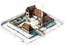
An archaelogical survey was carried out in 1994 to investigate the survival of features on the moated platform. The monument survives as an extant alignment of four fishponds with a central moated platform (RCHME earthwork survey, November 1993) which has recently been cleared of over-mature trees and scrub as part of an ongoing management agreement.
Despite a degree of erosion to the culverts between the individual fishponds the two larger ponds and the moat itself still retain a considerable amount of water. The site lies on the edge of the plateau gravel overlying London Clay. (from Wikipedia: London Clay is a marine deposit which is well known for the fossils it contains. It is the most important member of the Lower Eocene Epoch strata in the south of England, and the only European source of diverse plant fossils from the Lower Eocene. The fossils indicate a moderately warm climate, the flora being tropical or sub-tropical. London Clay consists of a stiff, bluish coloured clay which becomes brown when weathered. Nodular lumps of pyrite and crystals of selenite frequently occur within the clay, and large septarian concretions are also common. These have been used in the past for the manufacturing of cement.)
Here is an extract relating to the Geophysical Survey of 1994.
"Introduction
The aim of this survey was to investigate the survival of archaeological features on the moated platform S of the village of Ufton Nervet, Berks. The monument survives as an extant alignment of four fishponds with a central moated platform which has recently been cleared of over-mature trees and scrub as part of an ongoing management agreement. Despite a degree of erosion to the culverts between the individual fishponds the two larger ponds and the moat itself still retain a considerable amount of water. Currently the site is undergoing a long term programme of conservation works and it is planned to completely clear and replant the moated platform allowing public access to the restored monument. Despite the occurrence of a high concentration of tile and possibly articulated flint nodules observed in the root plates of wind-felled trees on the platform there is little documentary evidence to aid the interpretation of archaeological activity on the site. It was hoped that geophysical survey would elucidate the presence of any substantial building remains and contribute towards the production of on-site interpretation panels for the final presentation of the restored monument. The site lies on the edge of the plateau gravel overlying London Clay.
Method
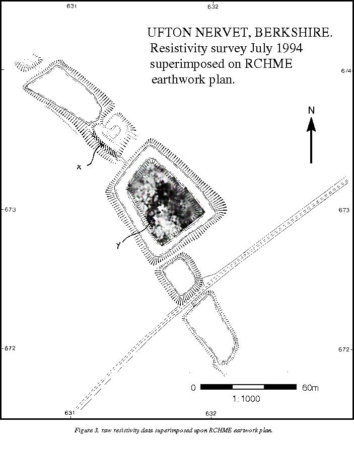
Due to the enclosed nature of the site an earth resistance survey was deemed to be the most appropriate technique to identify buried wall footings. A survey grid of partial 30m squares was established from a base line running through the centre of the site which was positioned in relation to two uniquely labelled oak trees identified as part of the site conservation programme. The area was then surveyed with a Geoscan RM15 resistance meter using the twin electrode configuration with a mobile probe separation of 0.5m. Readings were logged at 1m intervals along successive NS traverses separated by 1m intervals and the data was downloaded to a microcomputer in the field.
Results
The raw data demonstrates the wide dynamic range of the data recovered from the moated platform and the concentration of extremely high readings to the W of the site. There is little evidence of linear anomalies and the tentative identification of anomalies associated with former building foundations has been obscured by disturbance from felled trees. The strongest evidence for the presence of wall footings exists to the W of the site, although this interpretation is of a highly tentative nature and can only be resolved by trial excavation. The occurrence of two distinct areas of high resistance readings may well indicate the presence of subsurface building rubble and indeed it was noted in the field that these areas coincided with a concentration of tile scatter on the surface. Correlation of the data with the RCHME earthwork plan is limited to the coincidence of an area of lower resistance immediately N of the inner topographic feature with a similar low resistance area to the W in the vicinity of the wind-felled root plate containing the articulated flint nodules.
Conclusion
The survey has been hampered by both the key-hole nature of the area available and the inevitable disturbance caused by the wind-felled trees and scrub. The concentration of high resistance readings possibly suggests the presence of building debris. However, the amorphous nature of these anomalies may indicate the poor structural integrity of any surviving remains. It should be noted that despite heavy rainfall immediately prior to the survey, conditions at the site were particularly dry leading to problems associated with high surface contact resistance."
To log the cache :
Post a photo of you or your GPS (without the information board in it) at the site along with your log. A fishing pose would be excellent!
and answer the following questions via email - all answerable from the above co-ordinates and this cache listing :
1. According to the text under the painting, how many modern excavations have taken place?
2. London Clay is a marine deposit well known for containing what?
3. What colour is London Clay?