Introduction: More than half the world’s population lives in coastal regions, and many people visit the coast frequently. Most come for seaside recreation, but some also wonder about the origins of coastal scenery. A walk along the shore or a coastal footpath prompts questions about how such features as cliffs, rocky outcrops, beaches and dunes formed, and how and why they are changing. A coastal journey is likely to encounter estuaries, lagoons and river deltas that have evolved over longer periods, and it soon becomes clear that sea level has not always been where it is now. Coastal geomorphology deals with the shaping of coastal features (landforms), the processes at work on them and the changes taking place. Coastal geology is concerned with the rock formations and structures seen in cliff and shore outcrops, and the sediments that have been deposited in coastal regions. It provides the background for coastal geomorphology.
Apart from incidental comments by classical Greek and Roman observers and by Leonardo da Vinci, the first systematic attempts to explain coastal landforms were by 19th century scientists such as Charles Lyell and Charles Darwin, and the pioneer American geomorphologist William Morris Davis.While a great deal of work was done in the 20th century on various parts of the world’s coastline, particularly in Europe and North America, it is only in the past few decades that coastal research has become widespread, and there is still plenty of opportunity for original contributions (Bird, 2008).
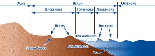
Beach anatomy: The coast consists of a number of zones. The shore is the zone between the water’s edge at low tide and the upper limit of effective wave action, usually extending to the cliff base. It includes the foreshore, exposed at low tide and submerged at high tide, and the backshore, extending landward from the normal high tide limit, but inundated by exceptionally high tides or by large waves during storms. The shoreline is strictly the water’s edge, migrating to and fro as the tide rises and falls. The nearshore zone, comprising the surf zone (with breaking waves) and the swash zone (covered as each wave runs up the foreshore), also migrates to and fro as the tides rise and fall. The breaker zone (where waves are disrupted) is bordered seaward by the offshore zone, extending to an arbitrary limit in deep water. The terms offshore, onshore and longshore are also used to describe directions of flow of wind, water or sediment. A beach is an accumulation of loose sediment, such as sand, gravel or boulders, sometimes confined to the backshore but often extending across the foreshore as well. Some beaches extend down to, and below, low tide level. Shingle is beach gravel, especially where the stones are well rounded. The coast is a zone of varying width, including the shore and the nearshore zone, out at least to the line where waves break, and extending inland to the limit of penetration of marine influences: the crest of a cliff, the head of a tidal estuary, or the rising ground behind coastal lowlands, or dunes, lagoons and swamps. The coast is thus the zone where land, sea and air (the lithosphere, hydrosphere and atmosphere) meet and interact. It is subject to an array of processes, including tectonic movements (upward, downward or laterally) of the land margin, changes in sea level, the effects of tides, waves and currents in the sea and variations in temperature, pressure and wind action in the atmosphere. Some coasts have been shaped primarily by erosion, others by deposition. Erosion is the removal of rock material, and the term denudation is used where surface rock is removed to expose underlying rock formations and structures to further erosion. The term coastline indicates the land margin at normal high spring tide (behind the backshore zone), and may be the base of a cliff or the seaward margin of dunes or dry land.
Coastline morphology: Maps, charts and satellite imagery show that
few of the world’s coastlines are straight: even those of simple outline are typically gently curved. Applying this "rule of thumb", then it stands to reason that a coastline that detracts from these defined shapes is obviously controlled by other processes be they a single process or a symbiosis of two or more processes.
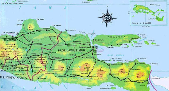
The appearance of a straight or linear coastline invariably means the interaction of geological faults. An example of a linear coastline is the north coast of
Madura in Indonesia, which may be related to a major fault line.
The almost straight 800 km east coast of Madagascar could also be fault guided, but it includes depositional sandy barriers shaped by Indian Ocean swell, and has not been produced directly by faulting. Probably the best example of a fault coast is seen in California north of San Francisco, where the coastline runs along the
San Andreas Fault NW to the
Bolinas Lagoon, and then follows the fault along the inner (eastern) shore of the Point Reyes peninsula bordering Tomales Bay.
Dynamics: Coastlines are highly dynamic places. They are constantly changing as a result of processes at work in coastal waters which include winds, waves, tides and currents and together provide the energy that shapes and modifies a coastline by eroding, transporting and depositing sediment. Geological processes such as
transgression and
regression are slower and less noticeable on a day-to-day basis but very important in creating emerged and submerged coastlines.
The EarthCache: Three-quarters of the world’s coastline is cliffed and rocky.This EC takes you to a rocky shoreline that has been shaped by both geological forces as well as marine processes.
Do not attempt to do this cache on stormy days: deaths have resulted from people being caught unawares by rogue waves and washed out to sea or bashed against the rocky shore. The strategically placed faults at this location have created a channel in the limestones. At this location estimate
1 - the width of the "channel" at the widest point and
2 - the orientation of the enclosing faults.
Geological setting: The Cretaceous limestone sequences west of Lisbon in the Quinta Da Marinha - Guincho areas are covered with younger sediments (both marine and aeolian). However, where the outcrops are found, they invariably show the effects of the emplacement of the nearby
Sintra batholith. Radial faults from this batholith are common and have helped shape small portions of the coastline forming several "cutouts" in the original curvilinear coast. Go and see one such cutout before it disappears.
Sources:
Bird, E, 2008. Coastal Geomorphology: An introduction. John Wiley and Sons, Ltd.
Holmes, A, 1993. Principles of Physical Geology. Nelson Thornes Ltd, 791p.

RECORTES
Costa do Guincho: N38º 41.721 W9º 27.535
Introdução: Mais de metade da população mundial vive em zonas costeiras e muitas pessoas visitam a costa regularmente. Muitas vêm à costa por razões recreativas. No entanto a morfologia da oral costeira é uma das coisas que pode suscitar muitas perguntas: Porquê as arribas? Porquê os afloramentos? Porquês as praias? Porquê as dunas? Como é estes aspectos costeiros se formam e como é que mudam de forma?
Morfologia da orla costeira: A consulta de mapas e imagens de satélite mostram claramente que a nossa costa é tudo menos uma recta e é quase sempre uma linha curva. Sendo assim, qualquer orla costeira mais rectilínea indica a acção de factores geológicos ou processos marinhos ou a combinação dos dois. Uma orla costeira em recta é provavelmente indicadora da localização de uma falha geológica.
A EarthCache:Três quartos da linha costeira do mundo são constituídos por penedos rochosos e arribas. Esta EC leva-te a um local da linha costeira rochosa onde são visíveis as acções marinhas e processos geológicos. As falhas paralelas nesta localidade criaram um canal. Para poderem logar a cache têm de me dizer qual a largura do canal no ponto mais largo e qual a orientação das falhas. Nota:Não tentem fazer esta cache em dias de temporal. Muita gente já foi arrastada por ondas nestas localidades.
Enquadramento geológico: Os calcários do Cretácico na zona do Guincho-Quinta da Marinha estão cobertos com sedimentos mais recentes de origem eólica e marinha. Os afloramentos de calcário retratam os efeitos da implantação do maciço de Sintra que gerou uma série de falhas radiais à sua volta. Os retalhos em torno destas falhas ditam a morfologia da orla costeira nesta zona.

 The most exciting way to learn about the Earth and its processes is to get into the outdoors and experience it first-hand. Visiting an Earthcache is a great outdoor activity the whole family can enjoy. An Earthcache is a special place that people can visit to learn about a unique geoscience feature or aspect of our Earth. Earthcaches include a set of educational notes and the details about where to find the location (latitude and longitude). Visitors to Earthcaches can see how our planet has been shaped by geological processes, how we manage the resources and how scientists gather evidence to learn about the Earth. To find out more click HERE.