From the guidelines, as from January 2013: "People do not need to wait for permission to log your EarthCache. Requiring someone to wait is not supported by the EarthCache guidelines. People should send their logging task answers to you, then log your EarthCache. When you review their logging task answers, if there is a problem, you should contact them to resolve it. If there is no problem, then their log simply stands."
Composition:
25.37 % Mg (42.06 % MgO), 14.57 % Fe (18.75 % FeO), 18.32 % Si (39.19 % SiO2 ), 41.74 % O
Physical properties:
Cleavage: [001] Good, [010] Distinct
Color: Yellowish green, Olive green, Greenish black, Reddish brown.
Density: 3.27 - 3.37, Average = 3.32
Diaphaniety: Transparent to translucent
Fracture: Brittle - Conchoidal - Very brittle fracture producing small, conchoidal fragments.
Habit: Massive - Granular - Common texture observed in granite and other igneous rock.
Hardness: 6.5-7 - Pyrite-Quartz
Luminescence: Non-fluorescent.
Luster: Vitreous (Glassy)
Streak: white
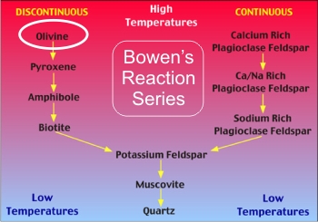 The olivine group of minerals is made up of a magnesium (Forsterite - Mg2SiO4) and a iron (Fayalite - Fe2SiO4) end member. It is one of the minerals that first year geology students come into contact with as it is one of the minerals that crystallise first in Bowen’s Reaction series.
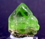
Minerals in the olivine group crystallize in the orthorhombic system (space group Pbnm) with isolated silicate tetrahedra, meaning that olivine is a nesosilicate.
Transparent olivine is sometimes used as a gemstone called peridot (a type of Forsterite), the French word for olivine. It is also called chrysolite, from the Greek words for gold and stone. Some of the finest gem-quality olivine has been obtained from a body of mantle rocks on Zabargad island in the Red Sea.
Olivine/peridot occurs in both mafic and ultramafic igneous rocks and as a primary mineral in certain metamorphic rocks. Mg-rich olivine crystallizes from magma that is rich in magnesium and low in silica. That magma crystallizes to mafic rocks such as gabbro and basalt. Ultramafic rocks such as peridotite and dunite can be residues left after extraction of magmas, and typically they are more enriched in olivine after extraction of partial melts. Olivine and high pressure structural variants constitute over 50% of the Earth's upper mantle, and olivine is one of the Earth's most common minerals by volume. The metamorphism of impure dolomite or other sedimentary rocks with high magnesium and low silica content also produces Mg-rich olivine, or forsterite.
Uses:
A worldwide search is on for cheap processes to sequester CO2 by mineral reactions. Removal by reactions with olivine is an attractive option, because it is widely available and reacts easily with the (acid) CO2 from the atmosphere. When olivine is crushed, it weathers completely within a few years, depending on the grain size. All the CO2 that is produced by burning 1 litre of oil can be sequestered by less than 1 litre of olivine. The reaction is exothermic but slow. In order to recover the heat produced by the reaction to produce electricity, a large volume of olivine must be thermally well isolated. Then it can produce power, while at the same time removing CO2. The end-products of the reaction are silicon dioxide, magnesium carbonate and small amounts of iron oxide.
The aluminium foundry industry uses olivine sand to cast objects in aluminium. Olivine sand requires less water than silicon based sand while providing the necessary strength to hold the mould together during handling and pouring of the metal. Less water means less gas (steam) to vent from the mould as metal is poured into the mould.
 Green sand
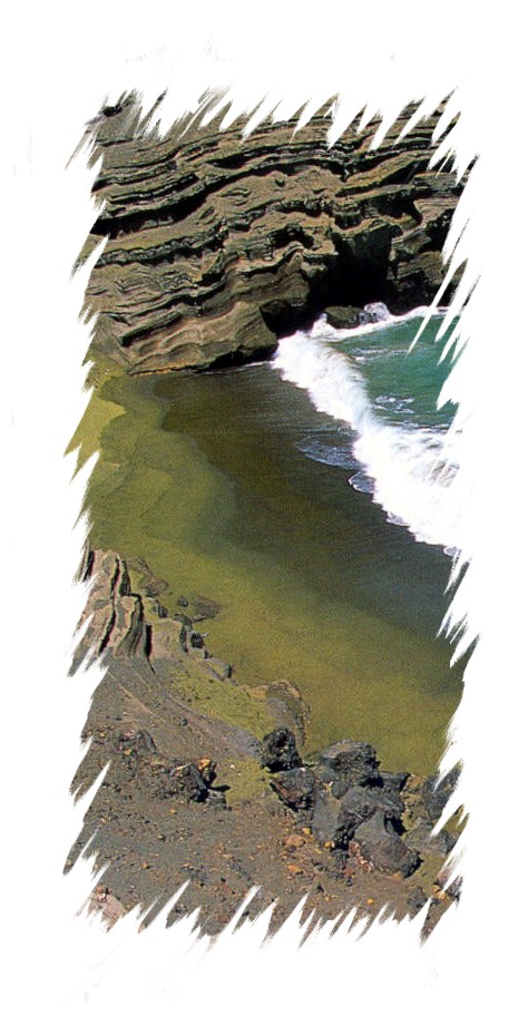
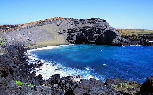
The term “green sand” is used to describe a beach made up of olivine crystals. One such beach, Papakolea Beach (also known as Green Sand Beach, Mahana Beach and, erroneously, Pu'u Mahana) is a green sand beach located at South Point, in the Ka'u district of the island of Hawai'i . It is one of only two green sand beaches in the world, the other being in Guam and as the name implies, the beach gets distinctive colouring from olivine crystals found in a nearby cinder cone. Note that the green sand is more abundant at the bottom of the cinder cone.
Papakolea Beach is located in a bay circled by Pu'u Mahana, a cinder cone formed over 49,000 years ago and associated with the southwest rift of Mauna Loa. Since its last eruption, the cinder cone has partially collapsed and been partially eroded by the ocean.
The cinder cone is olivine-rich.
Olivine is locally known as "Hawaiian Diamond" and is notably found in O'ahu's famous Diamond Headlandmark. The source of the green coloration of the beach sands is due to the olivine crystals which are winnowed from the eroding headland by the action of the sea. Olivine, being denser and tougher than the ash fragments, glass and black pyroxene of the rest of the rocks and lava flows, tends to accumulate on the beach whereas the usual volcanic sand is swept out to sea. Although these crystals are eventually washed away as well, the constant erosion of the cinder cone ensures a steady supply of sand for the foreseeable future—eventually, however, the supply will run out and the beach will look like any other.
The formation of the cinder cone is currently a point of contention, with some arguing that lava flowing into the sea was suddenly cooled, forming an edifice on the coastline and others noting that the cone was most likely too far away from the ocean at the time of formation to make such an event possible. Regardless of how it was formed according to the United States Geological Survey, the last lava flow in the area ended over 10,000 years ago, making the area one of the more stable features in the geologically turbulent Ka?u region. As such, the geologic history of the site can be seen in the rock surrounding the beach and bay, which are not subject to erosion and thus display geologic layers formed by previous eruptions, lava flows, and other volcanic events. In addition, the current patterns of erosion can be seen first-hand, as only the portions at the bottom of the cinder cone collapse have been subject to the waves and turned into green sand; the remaining portions appear gray.
Validating the EarthCache find
You already know that you will find the beach full of olivine grains so I’ll refrain from asking you about that. However, a closer inspection of the olivine grains will reveal something about their size. Therefore, in order to claim your found of this EarthCache please tell me:
1- What is the size of the grains of olivine you see?
Are they:
A - Less than 1 mm in diameter?,
B - Between 1 and 2 mm in diameter?
C - > 2 mm in diameter?
D - > 5 mm in diameter?
(I know that weathering is an active process here and the grain size may vary but I have several sand samples and your answer will be judged fairly) AND
2- What is the colour of the other grains that you find mixed in with the olivine grains?
If you have a nice pic of you on the beach or with the beach as a backdrop, please include it with your log (Note that this is OPTIONAL).
Getting there
Once on the Big Island ( Hawaii or Kona), take Highway 11 (the main highway) south to Ka Lae. There will be a sign pointing you further south to South Point, which incidentally is the southernmost point of the U.S.A. Eventually you will come to a parking lot and a little further off you have a boat ramp. Facing the boat ramp, look left and you will see a “Government Property” sign with a trail. Follow that well marked trail for some 9.7 km (~6 miles) to the EarthCache and Papakolea Beach . Take sun screen and plenty of water with you and don’t go with your beach sandals – wear good, comfortable hiking shoes.
Refs:
http://webmineral.com/data/Olivine.shtml
http://en.wikipedia.org/wiki/Olivine
http://en.wikipedia.org/wiki/Papakolea_Beach
http://en.wikipedia.org/wiki/Bowen%27s_reaction_series

 The most exciting way to learn about the Earth and its processes is to get into the outdoors and experience it first-hand. Visiting an Earthcache is a great outdoor activity the whole family can enjoy. An Earthcache is a special place that people can visit to learn about a unique geoscience feature or aspect of our Earth. Earthcaches include a set of educational notes and the details about where to find the location (latitude and longitude). Visitors to Earthcaches can see how our planet has been shaped by geological processes, how we manage the resources and how scientists gather evidence to learn about the Earth. To find out more click HERE.