"Rock In" Down The Highway Earthcache EarthCache
"Rock In" Down The Highway Earthcache
-
Difficulty:
-

-
Terrain:
-
Size:  (other)
Please note Use of geocaching.com services is subject to the terms and conditions
in our disclaimer.
|
|
|
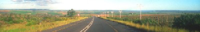
This virtual cache is an exploration / driving tour highlighting features of NJ’s Geologic History. There is no specific order that must be followed to complete this cache. The posted coordinates are a suggested place to start. To log a find for this Earthcache you must visit at least 2 of the posted locations within all 5 of NJ’s physiographic regions.
|
|
Valley & Ridge, Highlands, Piedmont, Inner Coastal Plain, & Outer Coastal Plain
|
| |
To log a find you must post: |
|

|
• |
The name of each physiographic location visited along with its region. |
| • |
At least 1 photo from each region. (Optional ) |
| • |
Describe in your log what the physiographic location i.e.tell about the soils, minerals, rocks, landforms, waterfalls, historic sites or museums you find. etc. |
| |
|
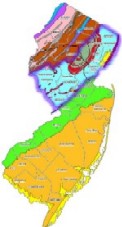
| Although one of the smallest states, New Jersey has a wealth of geological features--from billion year old rocks formed during continental collision to recent sediments deposited along the modern shorelines. NJ is divided into 5 separate geological provinces or physiographic regions: Valley & Ridge, Highlands, Piedmont, Inner Coastal Plain, & Outer Coastal Plain. |
| |
|
All 3 Periods of the Mesozoica Era, Triassic, Jurrassic, & Cretaceaous periods are well represented in NJ within these geological provinces. So how are these regions/provinces broken up? The Ridge & Valley lies in the far northwest corner and is considered part of the Appalacion Mountains. These Mountains slope southwest into the rolling hills of the Piedmont, an area of dozens of small lakes and rolling valleys. All that part of NJ which lies southeast of this area lies in the 2 coastal plains. These regions include portions of Middlesex & Mercer Counties and all of the Counties further south and east. In general the surfaces of the coastal plains are low flat plains that rise gradually from sea level along the coast to the Piedmont plain. Over ½ of this area lies below 100 ‘, except for the Rancocas Creek Drainage which consists of cuestos or ridges of low hills. The slope to the Atlantic Ocean east of the cuestos & ridges make up the Outer Coastal Plain. The slope west of the hills is called the Inner Coastal Plain. About 140 – 100 Million years ago these coastal regions were covered by oceans. As a result; during the Cretaceous & Tertiary Periods of the Mesozic Era the coastal plains became deposits of silts, sands, clays, greensands, & marls. Nearly all of these deposits contain fossils of marine animals.
|
| |
| Outer Coastal Plain Province |
| The most noted area of this region is the Pine Barrens. The highest elevation is at Apple Pie Hill & the next highest is the Forked River Mountain. After the oceans retreated during the Pleistocene Epoch which began 1 million years ago; there were major ice advances. During this time the land was sub-artic tundra and was greatly changed by sands & gravels deposited by streams leading away from the retreating ice in North Jersey. A major effect of this was the deposition of yellow sands and gravels. These soils are sandy, sedimentary deposits. There are 13 major types: Lakewood, Evesboro, Woodmansie, Downer, Sassafras, Aura, Lakehurst, Klej, Hammonton, Atsion, Berryland, Pocomoke & Muck. Look at this map of NJ. Can you guess where you might locate some of these soil types? Nearly all of these sands contain 90% Quartz. Other minerals are the feldspars, oxides, aluminum, & iron. |
|
|
Outer Coastal Plain Province Locations: |
| • |
Apple Pie Hill |
| |
N39°48.439 W74°35.377 |
| • |
Forked River Mountain |
| |
N39°50.865 W74°17.336 |
| • |
Island Beach State Park |
| |
N39°47.136 W74°05.688 |
| • |
Cape May Point (Sunset Beach) |
| |
N38°56.666 W74°58.204 |
| • |
Penn State Forest |
| |
N39°43.882 W74°29.316 |
| • |
Oswego River |
| |
N39°42.228 W74°31.630 |
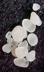
| Cape May Diamonds |
| The Native peoples were the first to find the fascinating and beautiful stones now known as "Cape May Diamonds." The Native Americans came to believe that these curious stones possessed supernatural power bringing success and good fortune. "Cape May Diamonds" are pure quartz crystals and are found in a variety of sizes and colors. The actual source of these amazing gems is in the faraway upper reaches of the Delaware River. Pieces of quartz crystal are eroded and broken off from veins and pockets by the swift running waters of streams. Then begins the some 200 mile journey that takes thousands of years to complete. The strong tidal flow against the hulk of the sunken concrete ship "Atlantus" is the cause for them to wash ashore in such great abundance. |
| |
| Inner Coastal Plain Province |
| The Inner Coastal Plain is comprised of several formations that are made up of sands, silts, clays, and marls that were laid down mostly during the Late Cretaceous. During the 40 million years of its formation, the Inner Coastal Plain experienced several oscillations of the rising (transgressions) and falling (regressions) of the sea level. This rising and falling cycle deposited the formations into three different shelf regions. These are the inner, middle, and outer shelf. |
|
|
Inner Coastal Plain Province Locations: |
| • |
Arney’s Mount |
| |
N40°00.586 W74°41.804 |
| • |
Trenton Hamilton Marsh |
| |
N40°11.458 W74°43.679 |
| • |
Haddonfield |
| |
N39°54.577 W75°01.751 |
| • |
Mount Holly Mount |
| |
N40°00.152 W74°47.301 |
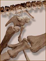
| A dinosaur was discovered |
| It was found in a marl pit in 1858 and was the first complete dinosaur skeleton found in N America or for that matter anywhere in the world. Realizing the significance of his find William Parker Foulke asked Joseph Leidy and Isaac Lea of the Academy of Natural Sciences of Philadelphia to evaluate it. Leidy's reconstruction of this skeleton revolutionized the understanding of dinosaurs. Today this site has become a National Historic landmark in Haddonfield. |
| |
| Piedmont Province |
| The Piedmont Province is a result of times of change. Sedimentary and igneous rocks, of the Triassic & the Jurassic accumulated in a large sedimentary basin known as the Newark rift basin. This basin formed during the breakup of the super continent of Pangea. A narrow sliver of Precambrian rocks is exposed in southern Mercer county. The Watchung Mountains are underlain by basalt; the Palisades, and Rocky Hill are underlain by diabase. The Piedmont generally has low relief--rolling hills and the like. The formations are mostly sedimentary rocks like sandstone, siltstone, shale, & conglomerates. Then there are the igneous rocks basalt & diabase that help form the geologic bedrocks. There is an outcrop in Prallsville that is more sandstone.. In contrast are boulders, like several that can be found in the Passic Formation. These boulders are known as erratics a harder resistant rock which transplanted from distant terrains. In some places, such as Milford, along the DSR, the rocks are less red and are called conglomerates. The typical basalt is dark red. This type is called igneous and is actually solidified lava. A similar rock is diabase formed from underground magma. Along the portion of the road north of Milford along the DSR lie walled outcrops of conglomerates, sandstones, siltstones, & shales. Dinosaur fossils of the Piedmont are 150 million yrs older than Hadrosaurus foulkii. Most of these are footprints of Anchisaurripus, Atricipus, Eubrontes, Gallator, & Rhynchosau. There is a footprint of Eubrontes on display at the NJ State Museum. |
|
|
Piedmont Province Locations: |
| • |
Eagle Rock Reservation |
| |
N40°48.214 W74°14.372 |
| • |
Prallsville (RT 29) |
| |
N40°24.644 W74°59.199 |
| • |
Watchung Resercvation (Trailside Nature Center) |
| |
N40°40.271 W74°37.218 |
| |
N40°41.001 W74°22.415 |
| • |
Sourland Mountain |
| |
(This mountain Range actually extends to the Delaware River) |
| |
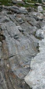
A typical Piedmont ridge formed by a very hard igneous rock called diabase or "Trap Rock."
The Sourland Mountain ends at the Delaware River below Goat Hill, looking south from the Lambertville toll bridge. To the south and north, diabase, shale, and argillite occurs, and these rocks form the lower lands we know of as Pleasant Valley. |
| |
N40°22.810 W74°56.968 |
|
|
• |
Sergentsville Covered Bridge |
| |
Wickecheoke Creek is fourteen miles long and drains a 26.57-square-mile watershed into the Delaware River at approximately N40° 24.376 and W74° 59 15.97 The watershed is underlain by poorly drained Lockatong argillite, a lake bottom deposit formed during the Triassic period, while the lower half is underlain by Stockton sandstone. |
| |
N40°26.640 W74°57.964 |
| • |
Buttermilk Falls |
| |
N40°57.069 W74 11.510 |
| • |
NJ State Museum |
| |
N40°13.261 W74°46.323 |
| • |
Rutgers Geology Museum |
| |
N40°29.909 W74°26.797 |
| |
| Ridge & Valley Province |
| The Valley and Ridge like its name implies, consists of alternating linear or curvilinear valleys and ridges of moderate relief. This is the eroded remnants of the Appalachian mountain system, which, when it formed over 300 million years ago, probably looked very much like the present-day Himalayas This province is characterized by widely varied topography ranging from the towering Kittatinny ridge to the sinkhole ponds and swamps of the limestone region. Within this area, the ridge is primarily composed of a hard quartzite conglomerate and sandstone caprock overlying shale. This shale was laid down during the Ordovician (470 million years ago), and the conglomerate was laid down in the Silurian (about 420 million years ago); both sedimentary rock layers were subsequently folded and uplifted during the Permian (about 270 million years ago) to their present position and angle with a pronounced dip to the northwest, resulting in prominent cliffs on the east side of the ridge and more gentle slopes on the west side. On the Kittatinny Ridge at the southern end, the conglomerate caprock is narrower and confined to the eastern part of the ridge. with increasing amounts of limestone on the western slopes along the Delaware River. |
|
|
Ridge & Valley Locations: |
| • |
Worthington State Park |
| |
N40°59.354 W75°05.488 |
| • |
High Point |
| |
N41°19.256 W74°39 690 |
| • |
Buttermilk Falls |
| |
N41°08.237 W74°53.306 |
|
|
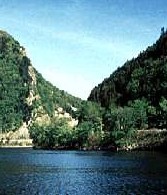
| Delaware Water Gap National Recreation Area |
| Delaware Water Gap is one of the best places to see water at Work. Millions of years ago this was a level plain; erosion and gradual uplift of the land formed the ridges and valleys we see today. What is distinctive about this gap is the beauty of the landscape. Here the river twists in a tight "S" curve through the Kittatinny Ridge. |
| 1. |
High on top of the Kittatinny Ridge is a blue lake, Sunfish Pond which is a National Landmark, a relic of the Wisconsin Glacier (which gouged out a hollow that later filled with water) around 18,000 years ago. N41°00.482 W75°04.372 |
| 2. |
Sunrise Mtn. - N41°13.081 W74°43.223 |
| 3. |
Bushkill Mtn. - N41°06.373 W74°59.095 |
| |
| Highland Province |
| This province is similar to the Valley & Ridge in terms of topography and geology. In fact, the only difference is that Precambrian metamorphic rocks are present in the Highlands These rocks are approximately 1 billion years old, they include gneiss and marble, and were deformed in the Grenville orogeny which involved the collision of plates in Precambrian time. These metamorphic rocks were then re-deformed during the same mountain-building phases that affected the Valley & Ridge province. The highlands are higher then the Piedmont and are marked by a fairly abrupt change; an escarpment. It is here that the Ramapo Fault lies. This fault is a zone that is 3 -6 miles wide and began forming around the Precambriam time. |
|
|
Highland Province Locations: |
| • |
Ramapo |
| |
N41°04.903 W74°11.886 |
| • |
Ken Lockwood Gorge |
| |
N40°41.822 W74°52 361 |
| • |
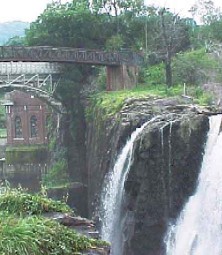
Great Falls |
| |
N40°54.950 W74°10.870 |
| • |
Palisades |
| |
N40°59.864 W73°54.249 |
| • |
Highlands - A |
| |
N40°23.153 W73°59.100 |
| • |
Highlands - B |
| |
N40°23.115 W73°59.067 |
 |
 |
| If you have any comments or if this cache need attention, please email us by clicking HERE |
 |
While out geocaching, bring a bag with you to pick up trash along the way. Visit the Cache In Trash Out page to learn more about CITO. |
|
Additional Hints
(Decrypt)
Rkgen Perqvg nabgure vagrerfgvat cynpr
Gurer vf n pyvss znqr jvgu netvyyvgr A40 25.646 J075 03.623. Gur nern jurer gur pyvssf ner vf ba Fgngr Cebcregl/Ab gerfcnffvat, fb gurl unir gb or ivrjrq sebz gur ebnq. Gurer vf cnexvat sbe gur Q&E pnany gbjcngu gb gur fbhgu ba Eg 29 ng40 25.451 J075 03.604.