
 The Great Salt Lake is merely a tiny remnant of the much
larger Lake Bonneville. Lake Bonneville existed at various
sizes from about 32,000 to 14,000 years ago. At is maximum
Lake Bonneville covered much of western Utah and extended
across the borders with Idaho and Nevada and reached a maximum
depth of 1000 feet.
The Great Salt Lake is merely a tiny remnant of the much
larger Lake Bonneville. Lake Bonneville existed at various
sizes from about 32,000 to 14,000 years ago. At is maximum
Lake Bonneville covered much of western Utah and extended
across the borders with Idaho and Nevada and reached a maximum
depth of 1000 feet.
During this time, the climate was wetter and colder than the
current climate. Lake Bonneville was a relatively fresh water lake
that was filled with rain water, rivers, streams, and melting
glaciers. 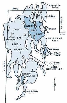
Image source: Utah Geologic Survey, Lake
Bonneville
(http://www.ugs.state.ut.us/online/PI-39/pi39pg01.htm)
For most of its history, Lake Bonneville was a terminal lake
because and had no natural outlet to the ocean. It continued
filling until about 16,800 when it reached the elevation of Red
Rock Pass in Idaho. Once the lake water began flowing over this
pass, the water rushed out eroding out about 375 feet of rock in
less than a year. The lake level stabilized here for about 600
years then began falling to approximately the level it is at now as
the climate became drier and hotter and evaporated the water out of
it.
The evaporation removed the water from the lake, but left the
small amounts of salts that are transported into the lake by the
rivers that drain into it. Over the thousands of years, more salt
is transported to the lake by the rivers and concentrated in the
lake by the evaporation of the fresh water.
From the coordinates, ancient shorelines of Lake Bonneville can
be seen on the hillside to the south. The shorelines are the
horizontal terraces that ring the hillside. Four major shorelines
have been recognized for Lake Bonneville.
They are:
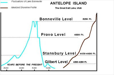
| Name |
Elevation |
Age (years before present) |
| Gilbert |
4,275 |
12,800-11,600 |
| Provo |
4,840 |
16,800-16,200 |
| Bonneville |
5,220 |
18,000-16,800 |
| Stansbury |
4,445 |
24,400-23,200 |
Data and graph source: Utah Geological and Mineral
Survey http://www.ugs.state.ut.us/maps/geohazmap/pdf/m-73.pdf (This
PDF also has a nice map of the area covered by Lake Bonneville
during each of these periods)
Each represents a time period where the lake levels remained
relatively constant for a long period to allow erosion to create a
terrace shore. These shorelines can be seen on the hills throughout
the entire region since the lake eroded a shoreline all along its
shores. On the other side of the island you can view the shorelines
at N 41 1.141 W 112 11.694. From this point you should be able to
pick out some of the shorelines along the mountains to the
east.
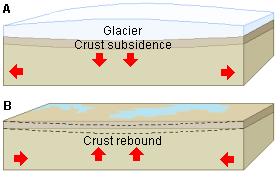 However, the shorelines on Antelope Island
are about 150 feet higher than on the surrounding mountains
because of a concept called
isostatic rebound. The weight of the water in Lake Bonneville
actually pressed the earth’s crust down. As the weight of the water
was removed the earth’s crust came up again, increasing the
elevation of the island. In the diagram substitute lake water for
the ice.
However, the shorelines on Antelope Island
are about 150 feet higher than on the surrounding mountains
because of a concept called
isostatic rebound. The weight of the water in Lake Bonneville
actually pressed the earth’s crust down. As the weight of the water
was removed the earth’s crust came up again, increasing the
elevation of the island. In the diagram substitute lake water for
the ice.
If you take the hiking trail around to the point (at N 41 1.665
W 112 15.551) the trail passes across one of these ancient shore
lines. The rocks on the trail change from the very angular typical
of freshly broken rock to the smooth rounded typical of well
weathered rocks on a beach.
Logging requirements:
Send me a note with :
- The text "GCZ9C3 Ancient Shorelines of Lake Bonneville" on the
first line
- The number of people in your group.
- The number of shorelines you can see on the mountain. Include
the criteria you used to identify them.
The above information was compiled from the
following sources:
- Willis, Grant C. et al, Geology
of Antelope Island State Park, Utah in Geology of Utah’s Parks and
Monuments, 2003 Utah Geological Association Publication 28 (second
edition) D.A. Sprinkel, T.C. Chidsey, Jr. and P.B. Anderson,
editors
- Utah Geological Survy, Lake Bonneville, PI-39
Commonly Asked Questions About Utah’s Great Salt Lake and Ancient
Lake Bonneville,
http://www.ugs.state.ut.us/online/PI-39/pi39pg01.htm
- Tamara Jo Wambeam, ISOSTATIC REBOUND AND LAKE
BONNEVILLE, University of Utah,
http://www.earth.utah.edu/geoantiquities/ancient-evidence/rebound.htm
- Utah Geological Survey, Great Salt Lake,
http://www.ugs.state.ut.us/utahgeo/gsl/index.htm
- New World Encyclopedia, Glaciation,
http://www.newworldencyclopedia.org/entry/Glaciation