Parking for this bridge is a cinch, only 300 feet away. Please
do use caution climbing around the bridge in poor weather!
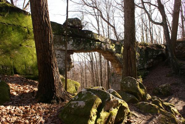
Creationg of a Natural Bridge:
A natural bridge is formed by erosion of rock through various
forces. This includes water (both frozen and running) and wind.
Bridges are also more easily formed in soluble (can be dissolved by
water) rocks such as sandstone, limestone, and basalt.
The natural bridge is essentially a giant sinkhole partially
eroded to form a large stone bridge. A wet weather spring located
behind the bridge in a rock cave probably contributed to the
erosion forming the arch. As water poured through the cracks and
froze during the cold months, it made the rocks loose and fall out,
leaving the bridge standing before you. The timetable for this
paticular bridge is uncertain but one can only assume it took a few
hundred thousand years.
To log this cache please send me the answers to these questions
and post your photo:
1. Post a photo of you and your GPS under the bridge.
2. How thin is the thinest point on the bridge?
3. Where does the spring currently flow?
4. How long do "you" think it took to create this bridge?
Thanks for visiting this unusual place hidden in a beautiful
section of Tennessee!