Geyer ist eine kleine Stadt mit etwa 4000 Einwohnern ungefähr eine halbe Stunde Südlich der Sächsischen Stadt Chemnitz gelegen. Die erste Erwähnung fand Geyer 1381, aber der erste Bergbau begann wohl noch früher. Durch den Bergbau erhielt dieser Ort auch den Status Bingestadt.
Eine Binge ist ein großes Gebiet bei dem die Erde durch Bergbau eingebrochen ist. Das ist ein recht seltenes Naturdenkmal.
Der Earthcache “Glück Auf! Binge – Geyer” zeigt euch dieses geologische Denkmal. Sicher waren einige Geocacher hier schon mal und haben den schönen Tradi "de Binge" von cala gefunden.
Wir wollen dem keine Konkurenz machen und haben daher kein Döschen versteckt - sondern euch einen Earthcache zur Wissenserweiterung gebastelt:
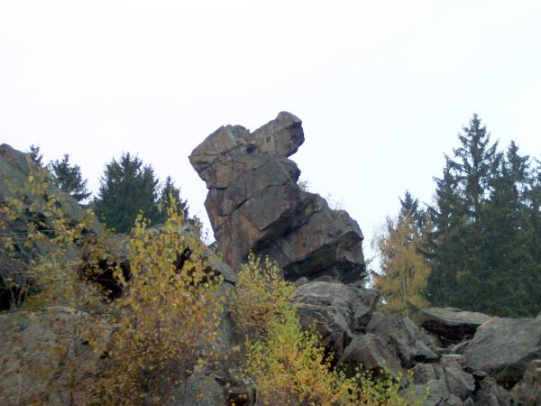
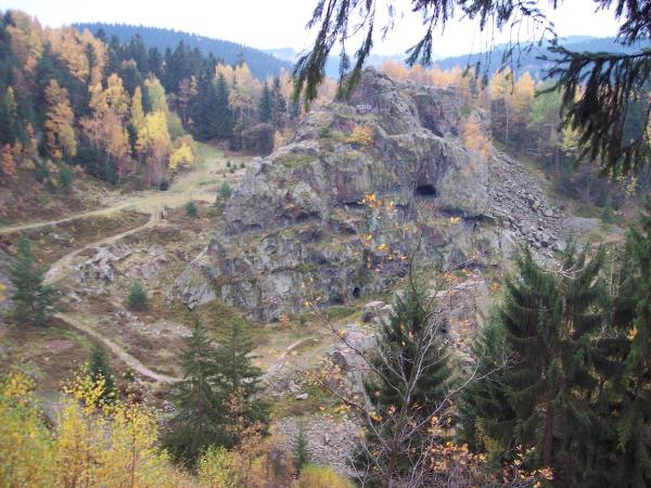
Die Binge in Geyer ist ein ehemaliges Bergwerk am Geyersberg. Hier wurde hauptsächlich Zinn gefördert, aber auch Silber, Kupfer und anderes. Da das Gestein sehr hart war (Granit), wurde vor allem durch Feuersetzen abgebaut. Dadurch entstanden Hohlräume von bis zu 40 Meter Durchmesser und 35 Meter Höhe.
Jedoch wurden viele und zu dicht beieinander liegende Hohlräume und Gänge dem Bergwerk schließlich auch zum Verhängnis. Bereits 1704 kam es zu ersten Einstürzen und 1803 folgte der große Zusammenbruch.
Heute kann der ca. 60 Meter tiefe Kessel des Einsturzes auf befestigten Pfaden, auch auf eigene Faust bei eigenem Risiko, besichtigt werden.Mineralogisch interessant ist der so genannte Stockscheider-Pegmatit der sich als Ergebnis der Kontaktmetamorphose zwischen Granit und Glimmerschiefer/Gneis gebildet hat.
Der Einbruchtrichter im Geyersberg bietet einen beeindruckenden Einblick in geologische Gegebenheiten und den Altbergbau. Er ist zugleich ein mahnendes Beispiel für den Raubbau an der Natur. Steinbruch- und bergmännische Arbeiten veränderten stellenweise stark das ursprüngliche Aussehen der Binge.
Nun zu euren Earthcacheaufgaben:
Ihr findet Informationen zur Binge bei den oben genannten Koordinaten und am Punkt: N 50°37.306 / E 012°55.633
Freiwillig: Findet außerdem die kleine Höhle bei N 50°37.249 / E 012°55.702 und die Infotafel in der Nähe von N 50°37.237 / E 012°55.667 und macht dort unten in dem Gebiet ein Foto für euren Log (du oder ein Teammitglied und die beeindruckenden Steine der Binge siehe Beispiel)
Mailt uns bitte die Antworten zu folgenden Fragen:
1. Schätze die Höhe des Eingangs der Höhle.
2. Nenne 3 typische Pflanzen des geologischen Gebietes Binge.
3. Welchen Umfang hat die Binge.
4. Wieviel Schächte gab hier es um das Jahr 1700 auf dem Berg und wieviel Bergarbeiter waren zu der Zeit zeitweise dort tätig?
ACHTUNG: Das neue Message Center wird nicht benutzt ! Nutzt bei Kontaktaufnahme, die Send Email Funktion und nicht das Message Center! - Danke!
Bitte loggt euer Foto mit ein wenn ihr wollt (bitte nicht per Mail senden) und gebt in eurem Log bitte keine Antworten auf die Fragen preis.
------------------------------------------------------------------------------------------------
Geyer is a small town of approximately 4,000 residents located about a half hour to the south of the city of Chemnitz in the German state of Saxony.The first mention of Geyer is in 1381, but there was mining going on in this area far earlier. It is >from this mining that it has its status as a Bingestadt ("Binge" city).
A "binge" is a large area of sunken earth created by the collapse of a mine. It is a rare natural monument. The earthcache “Glück Auf! Binge - Geyer” show you this geological monument.
The Binge in Geyer is a former mine nearly Geyersberg. Here it was mined primarily tin, but also silver, copper and other.
Because the rock was very hard (granite), it was diminished, above all, by fire putting. Hollow cavities from up to 40 metres of diameter and 35-metre height originated from it.
But these were too many and too close together recumbent hollow cavities and ways. This became to the mine, in the end, also the disaster. Already in 1704 it came to the first collapses and in 1805 followed the big breakdown.
Today the approx. 60 metre deep sinkhole of the collapse on fastened paths can be visited, also on own initiative with own risk. Mineralogisch is interesting the so-called Stockscheider-Pegmatit itself as a result of the contact metamorphosis between granite and mica schist / gneiss has formed.
The sinkhole of Geyersberg offers an impressive insight into geologic facts and circumstances and the old mining. It is at the same time a sending a reminder example of the overexploitation in the nature. Stone quarry-mannish and miner's works changed here and there strongly the original appearance of the Binge.
Now the Earthcache lessons:
You find information about the Binge near the abovementioned co-ordinates and on this point: N 50°37.306 / E 012°55.633
Find the little cave by N 50°37.249 / E 012°55.702 and the information board nearby N 50°37.237 / E 012°55.667 an take a photo on this area (->You ore one of the team and the impressive stones of the Binge)
Please mail (no message via message center) me and answer follow questions:
1. Estimate the height of the entrance of the cave.
2. Call 3 typical plants of the geologic area Binge.
3. Which perimeter has the Binge.
4. How many shafts here were there about 1700 on the Geyersberg and how many miners were active at the time at times there?
Please, don’t log the the answers! And load your photo with the geocaching-log (please don’t send the photo by mail)