Português
Póvoa de
Rio de Moinhos é uma freguesia portuguesa do concelho de Castelo
Branco, com uma área de cerca de 25,49 km².
Esta
aldeia, na qual vivem menos de mil pessoas, está sobretudo virada
para a agricultura. O azeite e a cortiça são aqui dois dos produtos
mais importantes a nível económico. A pecuária representa também
fatia importante das finanças das populações locais. A feira anual,
no segundo domingo de Outubro, traz à freguesia uma componente de
grande alegria e entusiasmo a nível comercial.
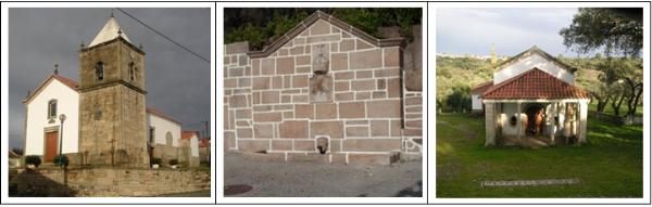
A romaria
local tem lugar primeira segunda-feira após a Páscoa e realiza-se
na bela Capela da Senhora da Encarnação, situada a cerca de 1 Km da
povoação, envolvida por uma deliciosa paisagem, na qual se alternam
as vinhas, pomares e sobreiros.
Em termos
patrimoniais, podemos encontrar diversos solares e casas
brasonadas, que se conjugam de forma harmoniosa com a arquitectura
popular, composta por humildes e bonitas casas com
balcão.
A igreja
paroquial, consagrada a S. Lourenço, é semelhante à maioria dos
templos rurais desta região. Algumas imagens sagradas no seu
interior merecem um olhar mais atento, bem como o
altar-mor.
English
Póvoa de
Rio de Moinhos is a Portuguese village near Castelo Branco, with an
area of about 25,49 km ².
In this
village, with less than 1000 inhabitants, the agriculture is the
main economical activity. The Olive Oil and the Cork are two of the
most important products produced here. The cattle also represents
an important part of the local finances. The annual fair, held in
the second Sunday of October, brings the village great joy and
enthusiasm at the commercial level.
The local
religious party happens in the first Monday after Easter at the
beautiful “Senhora da Encarnação” Chapel, situated about 1 km away
from the village, surrounded by a delicious landscape, in which
alternate vines, fruit trees and oak trees.
In
patrimonial terms, we can find several antique houses with
historical inscriptions, harmoniously combined with the popular
architecture, composed for humble and pretty houses with
balcony.
The
parochial church, consecrated to “São Lourenço”, is similar to the
majority of the agricultural temples of this region. Some sacred
images in its interior deserve a more intent look, as well as the
main altar.
Como chegar/ How to
arrive:
PT:
Na A23, saia na saída 24: Alcains, Penamacor. Siga depois as
indicações para Póvoa de Rio de Moinhos e estacione no centro da
aldeia, perto das coordenadas do primeiro
waypoint.
EN:
On A23 highway take the exit number 24: Alcains, Penamacor. Than
follow the signs to Póvoa de Rio de Moinhos and park at the centre
of the village, near the coordinates of the first
waypoint.
A
Cache/ The Hunt:
PT:
A procura desta cache começa com um passeio por diversos locais da
aldeia, onde deverá ser recolhida informação que permite obter as
coordenadas finais. O percurso inicial poderá ser efectuado a pé,
recomendando-se que estacionem junto das coordenadas indicadas, que
coincidem também com o primeiro waypoint. Neste local encontrará
informação para as letras A e B das coordenadas
finais, sendo que:
A = Último algarismo da
data inscrita na fonte.
B = Número de bicas da
fonte
A cache
final e o waypoint 4 encontram-se a cerca de 1Km de
distância.
EN:
The search for this cache starts with a walk around some places of
the village, in order to retrieve information to get the final
coordinates. The initial waypoints can be visited on foot, and it
is recommend to park your car near the given coordinates, which are
also the first waypoint. At this place, you will find information
for the letters A and B of the coordinates of the
final cache, as follows:
A = Last digit of the date
on the fountain.
B = Number of taps on the
fountain.
The final
container and waypoint 4 are located at about 1 Km of
distance.
Coordenadas Finais da
Cache:
N 39°
56.ABC
W 7°
30.DEF