Parkez votre voiture
en:
N50° 00.211
E4° 56.299
Les 2 derniers chiffres du numéro de GSM vous donnent A et
B.
Rendez-vous au WP1
en :
N50° 00.205
E4° 5B.213
Combien de pans comporte le toit du WP1 ? = C
Rendez-vous au WP2
en :
N50° 00.1(A-C)1
E4° 5C.70(A-1)
Combien de côté à la plus grande forme géométrique représentée
au WP2 ? =D
Rendez-vous au WP3
en :
N50° 00.D91
E4° 55.42B
Trouvez la bonne photo, elle vous donne E
Rendez-vous au WP4
en :
N50° E1.E1(C+D)
E4° 55.71A
Depuis un bon moment, vous empruntez la promenade numérotée sur
le panneau de WP4 = F.
Persévérez sur cette
voie et Rendez-vous au WP5 en :
N5E° (E*F)1.307
E4° 55.9(F+D)
Vous devriez apercevoir un numéro en rouge sur un arbre = G.
WP6:
N50° 01.(((F+G)*2)-A)0
E4° 55.8B(F-G-1)
Pour trouver le WP7, assignez les bons numéros des plaquettes
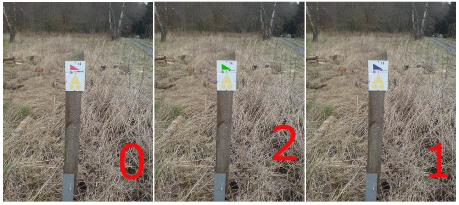
aux couleurs.
WP7:
N50° 01.1(jaune+vert+bleu-rouge-1)
E4° C6.(rouge-1)1
Combien de traverses en bois (plancher) y a-t-il au total ?
=H
Profitez-en pour faire une pause !
WP8:
N50° 01.0(H+F+(B-C))
E4° (H-F).261
Encore un pont!
Pas la peine de compter les planches, cherchez plutôt autour de
vous, un poteau I= (chiffre de gauche – chiffre de droite)
(Ces chiffres sont visibles depuis le pont).
WP9:
N50° 01.0IC
EI° 56.2((G*B)+3)
Quelle altitude! = J
WP10 :
Vous voici à la cache !!! Un peu difficile d’accès,
mais rassurez-vous, pas de danger pour y accéder.
N50° 00.(C+D)00
E4° 56.((I*H)+J+(C*I)+5)
Après avoir trouvé la cache… continuez votre chemin vers
le WP11.
WP11 :
N50° 00.5((I*G)-4)
E4° 56.((H*7)-G)
Une fois au WP11, poursuivez votre chemin et descendez vers le
moulin de la Galette pour récupérer votre voiture.
You are situated at the « Moulin de la Galette », old mill on the «
Houille », restored in 2000 and transformed into a bed &
breakfast . The walk begins along the fields near the village of
Sart-Custinne before crossing woods to join the « Houille ».
Approximately 2 hours of walk, roads are sometimes muddy! The
« Houille » is starting in Belgium in the region of
Gedinne where it collects waters of multiple small tributaries.
Having sprayed Gedinne, where it receives waters of
« Houillette », it goes northward, then changes gradually
direction towards the northwest. From Vencimont, it flows frankly
westward to the border. It realizes during some kilometres the
French-Belgian border in the southwest of Felenne. Then it goes
back again northward, on French territory, sprays Landrichamps then
Fromelennes and its hamlet Flohimont. It has its confluence with
the « Meuse » in the city of Givet. The GC599F –
That'll be nice is not far ... you will need only a few extra time
to make both caches.;-)
Park your car
at:
N50° 00.211
E4° 56.299
The 2 last digits of the cell phone number qill give you A &
B.
Then go to the
WP1:
N50° 00.205
E4° 5B.213
How many roof sides can you count at the WP1 ? = C
Go to the WP2:
N50° 00.1(A-C)1
E4° 5C.70(A-1)
How many sides has the biggest geometric form that you will find
on the WP2 ? =D
Go to the WP3:
N50° 00.D91
E4° 55.42B
Find out the right picture, it will give you E
Walk to the WP4
at:
N50° E1.E1(C+D)
E4° 55.71A
You are following the path that wear the number F that you can
find on the pannel at WP4.
Go on on this way until
the WP5 :
N5E° (E*F)1.307
E4° 55.9(F+D)
You should find a red number marked on a tree = G.
WP6:
N50° 01.(((F+G)*2)-A)0
E4° 55.8B(F-G-1)
To find the WP7, assign the right numbers on the pannels with
the right colours.
WP7:
N50° 01.1(yellow+green+blue-red-1)
E4° C6.(red-1)1
How many wooden crossbars (floor) is there all ? =H
Don't forget to have a break and enjoy the surrounding!
WP8:
N50° 01.0(H+F+(B-C))
E4° (H-F).261
Another bridge!
Don't waste your time counting the crossbars but rather look
around you to find a post I=(left number – right number)
(These numbers are visible when you are on the bridge)
WP9:
N50° 01.0IC
EI° 56.2((G*B)+3)
What is the altitude? = J
WP10 :
Here you are, near the cache !!! Maybe a bit difficult to access
to, but don't worry, no danger to reach it.
N50° 00.(C+D)00
E4° 56.((I*H)+J+(C*I)+5)
After you found the cache... go back to the path and go on to
the WP11.
WP11 :
N50° 00.5((I*G)-4)
E4° 56.((H*7)-G)
Once you are at WP11, continue your walk and go down to the
« Moulin de la Galette » to go back to your car.