MUSKEGON RIVER GAGING STATION - EARTHCACHE
 Purpose
This earthcache is designed to show the how today’s rivers are
monitored/regulated. The above coordinates above will take you to a
USGS gage station. USGS is the United States Geological Survey.
These gauging stations are used for water resources, specifically
the Muskegon River in this case. The station here is continuously
measuring the depth and the amount of flow of the river.
It is very important to monitor, and control the river’s flow for
several reasons. We can start with the control of flooding or at
least the warning of flooding. An important reason for this gauging
and regulating of the river is to limit erosion of the river banks.
Though erosion will always take place it can be held to a minimal.
Ground water also depends on these regulated flows. Ground waters
include some small lakes, marshes and wetlands.
A gaging station is a facility used by
hydrologists and others to monitor streams, rivers, lakes, canals,
reservoirs, and other bodies of water. Gaging stations typically
collect information such as water height and discharge (flow). The
collected information is recorded by a site visit or is transmitted
via telephone or a satellite communication system to the stations
owner.
Logging
Requirements
To log this cache you will need to complete the following.
- Post a picture of yourself/team with your GPSr and the gage
house in the background
- Post a picture of yourself/team with your GPSr and the Croton
Dam in the background
- E-mail the flow rates a the time of your visit, and for the
corresponding week prior -
Real time
data for this gage station
- E-mail the water lever the river was at the time of your visit,
and for the corresponding week prior. -
Real time
data for this gage station
- E-mail the water temperatures at the time of your visit, and
for the corresponding week prior -
Real time
data for this gage station
- In your e-mail, provide a brief explanation of the differences
in the water flow rate, depth, and temperature.
- Be sure to include the time you were there
- If prior week data is not available due to equipment
malfunction, use data for the day when equipment was functioning
properly again.
-
Each Cacher that logs a find is required to submit answers to the
questions
above***
(failure to comply will result in a deletion of your
log).
- The purpose of Earthcaches is for everyone to learn from their
visit/experience
- Combined photos are acceptable, but each cacher must be
identified.
All that should be posted with your log will be a photo.
The answers should be e-mailed to us (via our
profile) and not posted in your log.
Go ahead and log your find at the same time you're sending your
email answers.
***
= the only exception to this are young kids that are caching with
their parents (who have their own account, but not computer
privileges).
Muskegon River Gaging Station
The Muskegon River Gaging Station is operated by the USGS (United
States Geological Survey). This gaging station records water
height, discharge, temperature and transmits its data back to the
USGS headquarters in real time by
telephone.
The Muskegon River is a river in the western
portion of the lower peninsula of the U.S. state of Michigan. The
river has its headwaters in Houghton Lake in Roscommon County,
flowing out of the North Bay into neighboring Missaukee County. For
there it flows mostly southwest to Muskegon, Michigan, where it
empties into Muskegon Lake. Muskegon Lake is connected to Lake
Michigan via a mile-long channel.
The river has several major branches, such as the
Hersey River, Cedar Creek and
Little Muskegon River. The
Hardy Dam, one of the world's largest
earthen dams, is on the Muskegon River. Other dams include
Croton
Dam. Like many of its neighboring streams, the Muskegon river
was one of the favored logging rivers during the boom years of the
1880s-1890s, and a keen eye can still pick out remnants of stray
logs left over from the spring logging runs which embedded on the
river bottom. There is abundant wildlife, including otters,
waterfowl, deer and eagles and, although development has been
creeping in, the upper reaches are still fairly remote and natural
with much of the surrounding land composed of state-owned tracts.
In recent years, the river has gained a certain measure of fame as
a recreational fishery, boasting large migratory
steelhead,
brown trout
and planted
Pacific salmon.

The Muskegon River Watershed is located in north-central
Michigan and is approximately 219 miles long from its start at
Houghton and Higgins Lake down to its mouth at Muskegon Lake and,
eventually, Lake Michigan. The Muskegon River Watershed is
one of the largest in Michigan, spanning over 2,700 square
miles.second only to the Grand River Watershed. The Muskegon River
Watershed spans across the better part of nine counties: Wexford,
Missaukee, Roscommon, Osceola, Clare, Mecosta, Montcalm, Newaygo,
and Muskegon. Cities and towns located within the boundaries of the
Muskegon River Watershed include; Cadillac, Lake City, McBain,
Marion, Evart, Reed City, Big Rapids, Mecosta, Morley, Lakeview,
Howard City, Newaygo, Fremont, and Muskegon. An estimated
ninety-four tributaries flow into the main trunk of the Muskegon
River. The Muskegon River is fed by wetlands, groundwater
springs, lakes, agricultural drains, and warm, cool, and cold water
tributaries. The cool and cold water tributaries help to
sustain trout and other cool-cold water aquatic species in the
Muskegon River. Land Use/land cover in the Muskegon River
Watershed is almost an even mix of forest and agriculture.
Here is an interactive map of the
Muskegon
River Watershed (A watershed is an area of land that drains to
a common point)
The posted coordinates above will lead
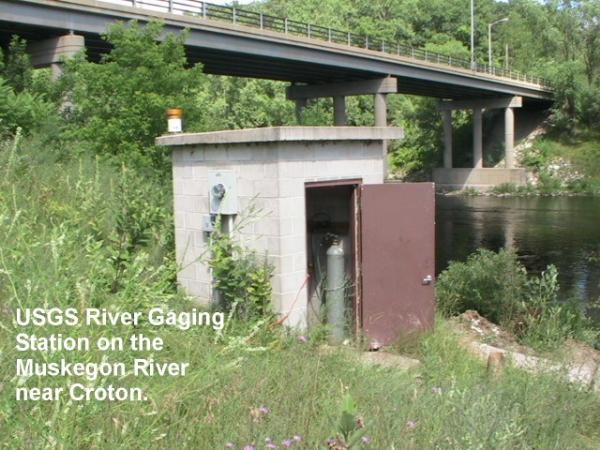
you to the gage house. This brick structure holds the stream gaging
equipment - typically a gage of some type, a computer, and
communications equipment. A stilling well or a vertical pipe is
located beneath the gage house. Water enters the well through one
or more inlet pipes. The water in the well rises to the same level
as the stream. Recording equipment in the gage house records the
water level in the well. Communications equipment transmits the
data to the USGS.
Station operated in cooperation with the
CONSUMERS ENERGY
This station is managed by the GRAYLING
FIELD OFFICE
Here is a
picture of the Gage House
and another picture looking upstream

Here is a
picture of the Croton Dam - walk North up the path from the gaging
station.
Gaging Station History
In the 1880's, John Wesley Powell, the second director of the USGS,
requested that stream flow be monitored in eight river basins in
the West. It was his idea to measure the flow of streams and rivers
and determine the viability of irrigation systems for this acrid
region. In 1889, the first U.S. stream gaging station was
established on the Rio Grande River in New Mexico. At this station,
standard stream flow measurement procedures were devised.
Today, the USGS operates and maintains more than 85% of the
nation's stream gaging stations. There are over 7,000 stream gaging
stations in the United States, Puerto Rico, and the U.S.
Territories of the Pacific Islands.
The USGS uses it's stream gaging network to provide a free
continuous source of well documented and archived water data. This
data is used by government agencies and private companies to
forecast flooding, design bridges, allocate drinking and irrigation
water, for recreational use, and to manage our valuable surface
water resources.
Real time data for this gage station may be found the internet at:
http://waterdata.usgs.gov/mi/nwis/uv/?site_no=04121970
Addtional Stuff
"Muskegon" is derived from the Ottawa Indian term ‘Masquigon’
meaning "marshy river or swamp." The "Masquigon" river was
identified on French maps dating from the late seventeenth century,
suggesting that French explorers had reached Michigan's western
coast by that time.
The North Channel Muskegon River (MI) 2007 RED JEEP Travel Bug -
Click here to view logs
The highest water level measurement was 16.80 ft on
09/12/1986
The lowest water level measurement was 0 ft on
07/17/1997
Congratulations to
WILLY for being
the first to find this
Earthcache.