The seeds of a fjord are laid when a glacier cuts a U-shaped valley through abrasion of the surrounding bedrock by the sediment it carries. Many such valleys were formed during the recent ice age. Glacial melting is also accompanied by a rebound in the earth's crust as the ice load is removed. In some cases this rebound may be faster than the sea level rise. Most fjords are, however, deeper than the adjacent sea; Sognefjord, Norway, reaches as much as 1,300 m (4,265 ft) below sea level. Fjords generally have a sill or rise at their mouth caused by the previous glacier's terminal moraine, in many cases causing extreme currents and large saltwater rapids (along the Pacific Northwest Coast of North America. Saltstraumen in Norway is often described as the worlds strongest tidal current. These characteristics distinguish fjords from rias (e.g. the Bay of Kotor), which are drowned valleys flooded by the rising sea.
Question: Where are fjords found?
Answer: The principal mountainous regions where fjords have formed are in the higher middle latitudes where, during the glacial period, many valley glaciers descended to the then-lower sea level. The fjords develop best in mountain ranges against which the prevailing westerly marine winds are orographically lifted over the mountainous regions, resulting in abundant snowfall to feed the glaciers. Hence coasts having the most pronounced fjords include the west coast of Europe, the west coast of North America from Puget Sound to Alaska, the west coast of New Zealand, and the west coast of South America. Other areas which have lower altitudes and less pronounced glaciers also have fjords or fjord-like features.
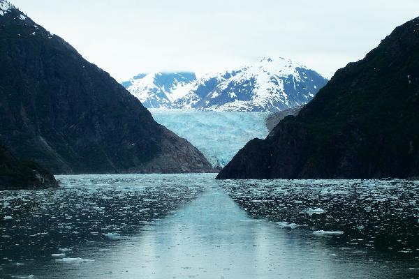
Tracy Arm is a magnificent glacier-carved fjord just south of Juneau. Many cruise itineraries include a visit to this incredible place, often as a substitute for the comparable Glacier Bay National Park.
The fjord is truly one of the most dramatic locations in Alaska, or in all of the world, for that matter. The sheer, glacier-carved walls are often shrouded in mist.
Visiting glaciers is surely one of the highlights of a journey to Alaska. There are an estimated 100,000 glaciers in the State, covering three percent of the landscape and creating most of its rivers. Glaciers are rivers of ice that flow from ice packs high in the mountains, where more snow falls than melts. In constant motion, they can move ahead at speeds of several feet a day, or sudden surges of as much as 300 feet. Some are retreating, or shrinking due to increased melting or a lack of new snow to feed them.
Tidewater glaciers flow to the sea and are found at the head of fjords or inlets which they carved while retreating. Calving occurs when pieces of a tidewater glacier break off and fall into the sea. The creaking sounds associated with calving glaciers and the roar as pieces fall into the sea are as impressive as the visual scene. The beautiful blue colour associated with glaciers is created by the density of the ice which absorbs all the colours of the spectrum except blue, which is reflected.
Glacial calving in Tracy Arm can often be quite spectacular, as huge chunks of ice break off and plunge into the frigid waters below.
Many of these chunks of ice are larger than several busses combined, so the effect can be simply jaw-dropping.
Literally hundreds of waterfalls cascade down the sides of the fjord, creating an almost otherworldly atmosphere.
Famed naturalist John Muir compared the glacial-carved sheer granite cliffs in the area to those of Yosemite, saying that this region was even more spectacular than the more well known Yosemite valley.
Today, Tracy Arm and nearby Endicott Arm are part of the Tracy Arm-Fords Terror Wilderness Area, itself part of the Tongass National Forest (can link to www.fs.fed.us/r10/tongass). Like national forests across the country, the Tongass is public land managed for a variety of uses, including recreation, wildlife habitat, timber harvests and more (can link to www.fs.fed.us). These lands belong to the American people and are managed for the benefit of present and future generations. Wilderness areas like Tracy Arm-Fords Terror are special parts of our public lands that Congress has permanently protected. Roads, timber harvests and development do not occur in these areas. Instead, they are preserved so that people can experience the myriad benefits of wilderness, including education, recreation, science, inspiration and spiritual renewal. To learn more about wilderness, and to find the federally designated wilderness area that is likely a day's drive from your home, visit www.wilderness.net).
One thing is certain when you visit Tracy Arm Fjord - you will be impressed and struck with awe at the magnitude and beauty of the place.
For visitors to Alaska who are not cruise passengers, tours of the fjord are available from nearby Juneau. It makes a wonderful day trip.
Shore excursions are also available from Juneau if your cruise itinerary doesn't include a stop here.
In addition to cruises of the fjord, other options are available in Juneau to explore this magical place.
Kayak excursions into the fjord are offered in Juneau. This is an incredible way to explore this pristine environment and observe its wildlife and other natural features.
However you get there, you are sure to be inspired and impressed by the grandeur and beauty of Tracy Arm Fjord. It is one place I highly recommend you include on your Alaska itinerary.
The Sawyer Glaciers at the end of Tracy Arm may not be the most famous glaciers in Alaska, but many visitors find them to be the most dramatic. Framed by mountains on either side, the glaciers are often bathed in a light mist that amplifies the blue hue of the ice.
This earthcache is meant to be cruise ship friendly. Each cruise ship and tour company must obtain permission to cruise the fjord and have a naturalist on board to explain the geology of the area as you travel along. You never have to leave the ship/tour to log your visit.
The photo that follow is of the Sawyer South Glacier. Near the posted coords you will be able to see the Sawyer North Glacier as well. As the glacier receeded up the canyon, the glacier split into two parts. At some point in time it was one glacier.
To log this cache as found, answer the following:
1. How long and wide is the Tracy Arm Fjord?
2. Estimate how high the walls of the canyon are.
3. What evidence exists to show that the Glacier formed the canyon and fjord?
4. What is different about the color of the water in the Fjord?
5. How much of the icebergs are still underwater?
6. OPTIONAL: Post a photo of you or your team at this location.
A special thanks goes out to the Rangers of the Tongass National Forest who helped secure permission for the placement of this earthcache and their time and dedication in making this a great place to visit.