Kysten ved Hornbæk / The coast at Hornbæk EarthCache
Kysten ved Hornbæk / The coast at Hornbæk
-
Difficulty:
-

-
Terrain:
-

Size:  (other)
Please note Use of geocaching.com services is subject to the terms and conditions
in our disclaimer.
Kysten ved Hornbæk / The coast at Hornbæk.
April 2020: Alle waypoints er flyttet grundet tilsanding af skrænten på gz, men nu er denne earth cache igen klar til besøg.
Waypoints updated after sand covered gz. This earth cache is ready for visitors.
Dansk:
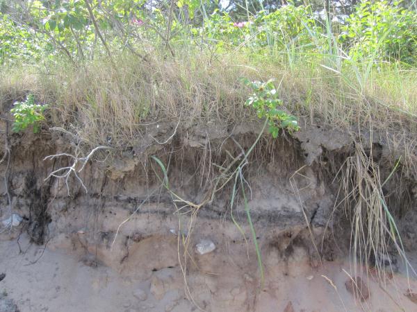
Kysten øst for Hornbæk er et geologisk interessant sted. Indeholder alle de elementer, som karakteriserer den nordsjællandske udligningskyst. Området betegnes som "abrasionsflak dannet ved bølgeerosion". Det vil sige, at kysten er præget af bølgerne, der skyller ind over landet og eroderer ("æder") kysten. Bølgerne tager det finkornede materiale (sand m.m) med ud i vandet igen og lader større sten og blokke blive liggende. Abrasion er et geologisk udtryk for den måde havet/bølgerne udjævner fastlandet/kysten, når det skyller ind over land. Abrasionsfladen - den jævne flade der er fremkommet efter bølgeerosionen - ender som regel op i en såkaldt forlandskant. En forlandskant er en 10-50 cm høj klint, hvor jordbundens lagdeling ofte kan ses pga. bølgeerosionen.
Læs evt. mere og Hornbæks kyst og de andre geologiske elementer, der findes i området her
Her ser du et foto af et sted på kysten, hvor forlandskanten fremstår meget tydeligt.
Denne earth-cache bringer dig til et sted på kysten, hvor der ses en forlandskant med tydelig jordbundslagdeling. For at logge cachen som fundet skal du svare på følgende spørgsmål:
Stå på stranden og kig på forlandskanten og det er korrekt at det er bag de væltede træer. Du kan fint komme helt tæt på skrænten:
1. Hvor høj er forlandskanten på dette sted? Målt fra strandniveau.
2. Hvor mange forskellige jordbundslag kan man TYDELIGT se? Og hvad er det?
Svarene skriver du i en email til mig via min profil og IKKE i din log. Du behøver ikke at vente på godkendelse af dine svar. Du får svarmail tilbage hurtigst muligt.
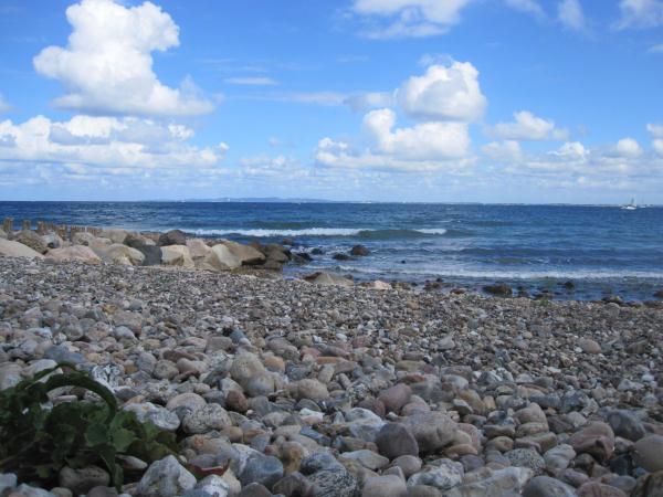
Jeg vil blive rigtig glade for et billede af dig selv på stedet - blot du sørger for at havet er i baggrunden, så svarene på spørgsmålene ikke kan ses ud fra foto'et. Alternativt kan du "bare" vedlægge et billede af den flotte udsigt eller området. Som f.eks. det Fodtusserne tog, da de var ude for at "lægge" cachen:
Hvis du vil lære mere om kysten her i området så er du velkommen til at besøge min earth cache: Litorinaskrænten ved Helsingør / Litorina slopes
English:
The coast east of Hornbæk is a geological very interesting place. It consists of all the elements which characterises the compensatory coast of North Sealand. The area are described as "abrasion shallow formed by wave erosion". It means, that the coast are formed by the waves, that washes over the land, "eats" the coast and leaves a flat area. The waves washes the fine-grained material into the sea again and leave stones and smaller blocks on the ground. The flat area formed by the waves end up in a small "cliff" called a "foreland edge". This is normally 10-50 cm high and you can see the layers of the soil in the "cliff" due to the wave erosion.
This earth-cache brings you to a place at the coast, where you can see a foreland edge with soil layers. To log this cache you must answer the following questions:
Stand on the beach and look at the foreland edge (it is behind som fallen trees, but you can get there):
1. What is the height of the foreland edge on this spot? Measured from the beach level.
2. How many different layers can you see in the foreland edge? And what is it?
Send the answers to me via my profile at geocaching.com and NOT in a log. Don't wait for me to approve your answers. If your answers are wrong, I will contact you. Feel free to log the cache as found. You will get an reply mail from me asap.
If you would like to take a picture of yourself or the area, and upload it, I will be very happy. Just make sure, that the answers to the questions is NOT visible at the photo.
If you want to learn more about the coast in this area please visit my earth cache: Litorinaskrænten ved Helsingør / Litorina slopes
Additional Hints
(No hints available.)