Neretva River
Neretva, the main river in Herzegovina, is 228km long and springs at 1320m altitude in the Dinaric Alps mountain range in an area called Jabuka (80km south of Sarajevo). Upon crossing a steep and impressive canyon and reaching the main valley in Konjic (81km from the spring), the river continues to flow gently for another 100km in the north-west direction arriving at Mostar. There it flows under the famous Old Bridge (Stari most) - built in 1566 according to orders from sultan Suleiman the Magnificent with one purpose – to connect the two river banks. The Bridge was destroyed in 1993 but was fully rebuilt since then.
The river continues to flow towards Jablanica but changes its direction and heads south to water the land of Croatia and joins the Adriatic Sea in the Ploce estuary. Neretva’s main tributaries on the right are Rakitnica, Rama, Trebižat and Drežnica; and Buna and Bregava on the left.
It is well known that the Valley has numerous tributaries which provide large quantities of water but also amaze spectators with their surroundings and diversity of colors in the environment. For example, the remarkable Boracko Lake (at 400m altitude, situated under a 2002m high hill called Prenj) created at the place where Rakitnica joins Neretva. The upper stream of Neretva has water of Class A purity and is almost certainly the coldest river water in the world, often as low as 7-8 degrees Celsius in the summer months. Neretva also has some endemic and very delicate, fragile life forms that are near extinction.
Formation of the Neretva Canyon
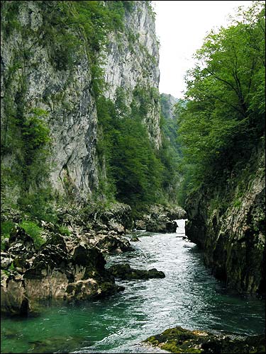
Neretva is a karst river. It forms an amazing canyon in the upper stream, somewhere about 2m wide. Bedrock is made of triassic and jurrasic limestone with karstic forms of relief.
The formation can be related to the natural tendency of river to reach a base line elevation - the point at which the river reaches the elevation of the large body of water into which it will drain. Essentially, the larger the difference in height between the river and  its inlet into a large lake, the more energy the river will expend in the process of erosion. Much of this energy will be expended towards increasing the efficiency of the drainage system, and facilitating a speedy drop in elevation. Obviously, the leading power is the incidence of mildly acidic water acting on soluble bedrock. The carbonic acid that causes these features is formed as rain passes through the atmosphere picking up CO2, which dissolves in the water. Once the rain reaches the ground, it may pass through soil that may provide further CO2 to form a weak carbonic acid solution: H2O + CO2 --> H2CO3. This mildly acidic water begins to dissolve the surface and any fractures or bedding planes in the limestone bedrock. Over time these fractures enlarge as the bedrock continues to dissolve. Openings in the rock increase in size, and an underground drainage system begins to develop, allowing more water to pass through and accelerating the formation of underground karst features – for example a sinkholes, that find place in Neretva too.
The creation of canyon coincides with the departure of glaciers from its valleys. As the ice began to melt, it not only released ancestral river beds from their icy prison, but it also released immense amounts of water. So much water was released and the river was provided with an incredible erosional potential. This extra water supply allowed it to rapidly alter its channel, and the down-cutting may have begun almost instantly. As the glaciers largely, eventually the initial deluge subsided, and the rate of erosion slowed accordingly, but didn’t stop. The Neretva Canyon continues to deepen even today. The rate may have slowed, but the process is unrelenting.
- estimate the width of the river stream at given coordinates
- names of at least another two rivers in region of Bosnia and Herzegovina and Montenegro, that form a canyon
- what is the elevation at given coordinates
DON'T CONTACT ME VIA PROFILE, JUST
FILL THE FORM. I'LL CONTACT YOU, IF SOMETHING IS WRONG.