
Eskers are ridges formed by retreating glaciers. As a glacier melts, the meltwater moves in streams beneath, within, and on top of the glacier, creating tunnels in the ice. At the bottom of the glacier, these ice tunnels fill with sediment, sand, gravel, even boulders, that are deposited by the meltwater. Once the glacier has retreated, long ridges of sediment are left behind. Some eskers are more than 500km long, while others are part of complex tributary systems of eskers.
The sediment material in eskers is sorted and stratified. Because of this, eskers are frequently used as sources for sand and gravel. Eskers are also commonly used to build roads upon, because they are naturally elevated and dry. In some areas with higher population density, eskers are considered to be endangered because of excessive development and excavation.
For further reading about eskers, please see the following sites:
http://www.canadiangeographic.ca/landforms/eskers.asp
http://en.wikipedia.org/wiki/Esker
http://www.thecanadianencyclopedia.com/index.cfm?PgNm=TCE&Params=A1ARTA0002642
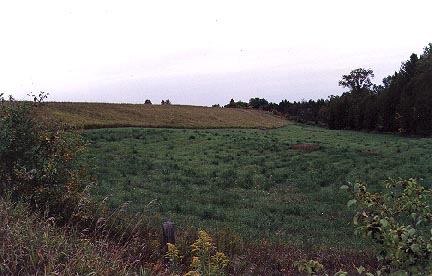
The Bridgenorth Esker runs from Young's Point to Fife's Bay. At Fife's Bay, the esker splits into at least three branches. The same meltwater stream that created the esker entered a proglacial lake at this point, making the Fife's Bay portion of the esker an esker delta. In addition to the development at Fife's Bay, the Bridgenorth Esker has had some excavation activity on it at various points. Please visit the following excellent website for further details about the Bridgenorth Esker and how it was formed.
http://www.bridgenorthesker.ca/whatis.shtml
And don't forget to look at Juicepig's nearby Earthcache, Peterborough Drumlin Fields (GC15AM7).
To log this Earthcache, you must complete the following three tasks:
1) The Bridgenorth Esker has been altered by development and excavation, and parts of it that are not altered by people are mostly covered in vegetation. This makes it hard to pinpoint exactly where it goes. Based on what you've learned about eskers in general, and the Bridgenorth Esker in particular, draw a rough outline of where the Bridgenorth Esker is on the map provided below. Just use Paint or a similar program to do this, and don't worry about making it pretty. Refer to a map if you need to.
Download the map here.
Email your drawing to me at narcissa1979-at-gmail-dot-com. Don't post the map with your log!
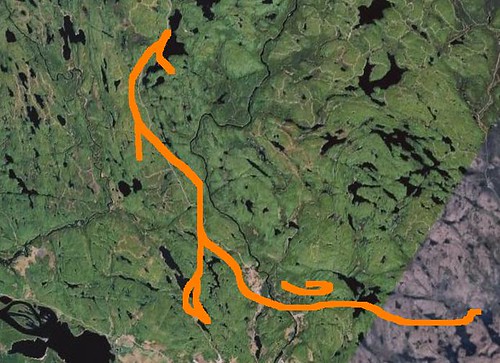
Here's an example drawing (not the same map though!)
2) You already know that eskers are a good source of sand and gravel. Now, do a bit of internet research (use the links provided in the cache page). In the email with your map, tell me another way that eskers can be used for a particular industry.
I always appreciate seeing photos, but none are mandatory to log this Earthcache!
Happy Earthcaching!