This EarthCache is part of a series of four EarthCaches, following the Falls Trail and Highland Trail, in a 5 mile hiking loop. This is one of three on the Falls Trail section. Hikers on the Falls Trail should be in good physical condition, wear sturdy boots, and use caution due to slippery/wet conditions and steep trail sections.
Ricketts Glen State Park is located on the Red Rock and North Mountains of the Allegheny Front. The Allegheny Front is an escarpment forming the boundary between two of Pennsylvania's main geologic regions, the Allegheny Plateau and the Ridge and Valley region. To the north the Allegheny Plateau consists almost entirely of horizontal layers of sedimentary rock. To the south of the escarpment, many tilted layers of sedimentary rock form the Ridge and Valley region. The Allegheny Front is capped by hard sandstone, in contrast to the less resistant shales and sandstones found in the Ridge and Valley below.
All of the exposed rock in the park was originally deposited as unconsolidated gravels, sands, and muds by ancient rivers that flowed across the region from about 370 to 340 million years ago, when what is now Pennsylvania, was located south of the equator. These sediments accumulated on flood-plains near sea level, and as the region subsided they became buried by other sediments. Several thousand feet down in the earth's crust these sediments were consolidated into solid rock by pressure and high temperatures. Then about 250 million years ago a collision between the North American continental plate and Africa deformed the rocks into the large tight folds of the Ridge and Valley and the gentler folds of the Allegheny Plateau. Continued erosion beginning at this uplift has removed over 5,000 feet of overlying rock to date.
Equally important in the formation of the park today were the glaciers. In the last million years at least three continental glaciers have buried northeastern Pennsylvania under thousands of feet of ice. The last glacial event happened about 20,000 years ago and left extensive evidence of it's advance. This glacier picked up large blocks of sandstone from the ledges, scoured up loose soil and rock, cut striations into the bedrock of the Pocono Formation, and finalized changes in the drainage pattern that were started by earlier ice sheets.
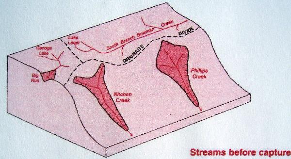
In preglacial times, the areas of what are now Lake Leigh and the eastern part of Lake Jean drained eastward down the South Branch Bowman Creek. Ganoga Lake and the area that would become the western part of Lake Jean drained westward down Big Run. The preglacial drainage divide between these areas and Kitchen Creek ran in an arc around the head of what is today the Glens.
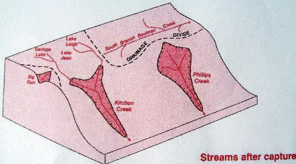
Glaciation altered the drainage pattern so that the stream in Glen Leigh captured the former headwaters of South Branch Bowman Creek and the stream in Ganoga Glen captured the headwaters of Big Run. Glacial meltwater also assisted the Glen Leigh branch of Kitchen Creek in the capture of Lake Leigh drainage. At the end of each glaciation the ice retreated northeastwardly and temporarily impounded a lake in the Bowman Creek Valley. The drainage from that proglacial lake cut a channel, or sluiceway, across the divide into the Glen Leigh Valley. It most likely took all three glaciations to finally cut the sluiceway deep enough so that the Lake Leigh area could continue to drain down through Glen Leigh after glaciation. Today, the divide between South Branch Bowman Creek and the stream in Glen Leigh is a broad valley occupied by a swamp, the abandoned sluiceway. Glacial deposition was also instrumental to the capture of the Ganoga Lake/western Lake Jean drainage by the Ganoga Glen branch of Kitchen Creek. The last glacier deposited 20 to 30 feet of debris blocking the Big Run Valley and forcing the drainage to follow its present path through Ganoga Glen.
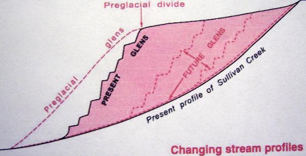
The result of these drainage changes was an additional 7 square miles added to the Kitchen Creek basin. It is this increased water flow that is responsible for cutting the waterfalls into the Glens. This is because the slope, or gradient, of the Glens is too steep to handle the present amount of water flow. Ultimately, the falls will gradually erode upstream until the gradient is reduced to an angle that can handle outflow of the present drainage basin of the Glens and the waterfalls will vanish.
The posted coordinates are for the Lake Rose parking area/trailhead. The Falls Trail and the Highland Trail is a 5 mile loop with challenging terrain but some of the best scenery in Pennsylvania. I see many families with children on the Falls Trail and they seem to do fine but please remember to keep an eye on them. Be sure to pick up a park map at the visitor center.
To claim this as a find:
1. Post a photo of yourself and your GPS at your favorite spot along the way. (This requirement is now optional)
2. Note the elevation at the bridge at the top of Ganoga Glen.
3. Note the elevation at the bridge at the top of Glen Leigh.
4. Note the elevation at the bridge at Waters Meet.
5. Determine the elevation difference of each glen.
E-mail the answer to number 5 to me within a few days of your log.
Failure to comply with this requirement will result in log deletion.
Good luck and good caching.
- Rev Mike