The Waimea Canyon was nicknamed the "Grand Canyon of the Pacific", some say by Mark Twain, however he never visited the Island and the time frame suggests he did not. Geologists shudder at the comparison, as there are no similarities, either in geological formation, or in size. On an Island the size of Kauai it is still a spectacular geological formation, measuring almost 13 miles long, up to 2.5 miles wide and almost 2800 feet deep.
The canyon was formed over the period of the last 5 million years by a number of Geological events.
The lava flows forming the west side of the canyon are approximately that age and are considered to be part of the original Volcano that formed the Island of Kauai. These flows are called the "Napali Member". If you look to the immediate left of the Lookout you will see that layers of lava are relatively thin and slope towards the Ocean.
Over the next one million years the area East of the canyon first suffered a "subsidence", which means a large portion of the Earth's crust settled, causing that area to sink. (All Islands in Hawaii have undergone various amounts of this). More Volcanic activity east of the Canyon again built up this area into what is now called the "Olokele Member". If you look across the Canyon you will see the lava layers there are much thicker and level, these are approximately 4 million years old. This was caused by the flows damming up against the west wall.
One more series of lava flows called the "Makeweli Member" fill a dropped down depression south of the Canyon and are visible to right. These are slightly older than the Olokele Member.
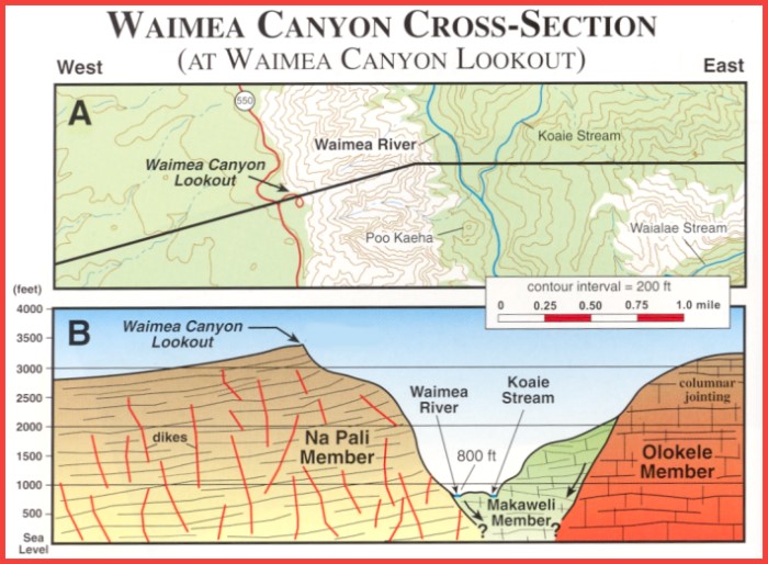
Picture with permission and courtesy of TEOK Investigations and Chuck Blay, Ph.D.
The next event in the formation of the canyon is erosion, and it began with the creation of a near perfect rain machine. If you look due east, and there is no cloud cover, 10.5 miles away you would see the top of Mount Waialeale. The area East of the mountain top experienced another subsidence or sinking called the Lihue Basin. This created 3200 foot cliffs on the east side of the mountain. Warm, moist trade winds, carrying puffy little trade wind clouds, blow from the east, and as they try to go up over these cliffs, start loosing their moisture in the form of rain. This makes Mount Waialeale one of the wettest spots on earth, averaging about 400 inches of rain a year. Much of the rainfall drains across the nearly flat top of the Olokele Member and has created over the centuries a high altitude Bog called the Alakai Swamp.
Reddish-Brown, Acid rich, water from this swamp drains into a number of streams which are tributaries to the Waimea River. Each of these tributaries has eroded their own Canyon in the East wall of the Waimea Canyon. Waimea translates into "Red River", and that river has carved the Waimea Canyon deeper over the centuries. The River below the Lookout is currently about 800 feet above sea level. A couple of the tributaries are very visible from the Lookout. If you look due North you will see the very visible Waipo'o Falls on the Koke'e Stream, and directly across the Canyon from you the Koai'e Stream and its Canyon.
After dropping their moisture on Mount Waialeale, the now very dry winds carry on over the Canyon, thus the canyon itself and the area west of the Canyon are one of the driest spots on earth, getting very little rainfall. You will note the sparse vegetation in both of these areas.
Thus you have the story of the ongoing creation of "Grand" Waimea Canyon of Kauai!
To log this cache you can post a log giving your impressions of the Canyon and at the same time send us an e-mail, through this link,, or a message through message center, with the answers to the following questions (do not post these answers in your Log !):
1. With information you gathered from the sign and information we provided above, how deep is the Canyon below the Lookout?
2. What is the predominate soil color in the Canyon?
3. Distances are deceiving in the Canyon so what is your estimate of the distance to Waipo'o Falls and how high do you estimate they are? (This is not a test and we will e-mail you the correct answers so you can check your own abilities.)
In addition we would like you to upload a picture to your Log, of you or your team on the Lookout with your GPS, and the Canyon in the background. (This is not a requirement)
(As there are usually many tourists at the site, you should not have trouble finding someone to take your picture!)
You must meet all of this criteria or your Log will be deleted after consultation.
A visit to the Koke'e Natural History Museum, at N22 07.816, W159 39.458, which is also the Interpretive Visitor Center for both Waimea Canyon and Koke'e State Park will provide you much more information on both Parks as well as Hiking trails.
References: Kauai's Geologic History, A Simplified Guide, Updated Edition
by Chuck Blay and Robert Siemers
published by The Edge of Kauai Investigations.

Waipo'o Falls as photographed from the Air by ScouterHerb