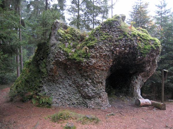
Naturdenkmal "Ofenloh"
Natural Monument "Ofenloh"
(meaning=oven's hole)
Deutsch
Das sogenannte "Ofenloh" liegt in der Nähe
von Münzkirchen in Oberösterreich. Die Besonderheit dieser
Formation ist, das er nicht aus einem Felsen besteht sondern aus
Kieselsteinen geformt ist (Konglomerat).
Während des Karpatium transportierten
Flüsse Schotter aus den Alpen. Kieselsäure aus den Obersten
Gesteinsschichten sickerte durch und verdichtete die unteren
Schichten. Die oberste Schotterschichten wurden später durch Wasser
und Schwerkraft abgetragen. Durch Hangrutschungen und
Witterungseinflüsse zerbrach die geschlossene Konglomeratdecke.
Einzelblöcke entstehen. Diese Entwicklung ist noch immer nicht
abgeschlossen.
Das "Ofenloh" und ein weiterer Steinblock
wurden als Naturdenkmal ausgewiesen. Sie liegen nah aneinander und
sind frei zugänglich.
Deine Aufgaben:
Ein Foto von Dir oder GPS mit dem Ofenloh im Hintergrund
sind wilkommen.
Miss die Entfernung zwischen den beiden
Naturdenkmälern.
Beantworte folgende Frage:
Vor wieviel Millionen Jahren wurde der Schotter mit den
Flüssen transportiert?
Schicke mir die
Antwort per mail und du bekommst eine
Logerlaubnis.
English
The so called "Ofenloh" is located near the
village Münzkirchen in Upper Austria. The speciality of this
formation is, that it is not formed out of a single rock but from
gravel (conglomerate).
During the carpathium river
transported gravel from the alps. Silica from the upper
layers soaked into the layers below and solidified them. The
gravel layer on top was later degraded by water and gravity.
The closed mantle of conglomerate broke up by slopesliding and
weathers influence. Single blocks of conglomerate evolved. This
development still continues.
The "Ofenloh" and a another block of
conglomerate are acceptet as a Natural Monument. They are
situated next to eachother and are open for puplic.
Your tasks:
Pictures of yourself or GPS with the Ofenloh in
the background are welcome.
Mesaure the range between the two natural
monuments.
Answer following questions:
How many million years ago the rivers transportet the
gravel?
Send me the
answers per mail and you will get the permission to
log.