
De cache voert langs een aantal leuke plekjes in het dorp en is
ongeveer 3 km lang. Onderweg worden een aantal vragen gesteld of
opdrachten gegeven. Met alle antwoorden is het eindcoördinaat te
berekenen.
De cache is geschikt voor het hele gezin. Ook goed te doen met
de fiets of met kinderwagen/buggy. De route is geheel verhard, maar
de laatste 50 meter is over een breed schelpenpad.
English Translation
Parkeer op het bovenstaande coördinaat. Vanaf hier start de
cache.
Eenrum
 Rond 600 jaar
voor Christus vestigden de eerste mensen zich in het Groningse
kustgebied. Eerst woonden ze in de lente en zomer in dit gebied. In
de herfst en winter werden de huizen weggevaagd door de zee. Door
het ophogen van de grond, de wierde, kon men het gehele jaar in
deze streek wonen. Van de wierde van het dorp Eenrum wordt
aangenomen dat deze al sinds het jaar 200 voor Christus vrijwel
continu wordt bewoond. Het dorp ontstond als agrarische
nederzetting. De Romaans-Gotische kerk uit de 13e eeuw en de
korenmolen de Lelie zijn beide van verre zichtbaar.
Rond 600 jaar
voor Christus vestigden de eerste mensen zich in het Groningse
kustgebied. Eerst woonden ze in de lente en zomer in dit gebied. In
de herfst en winter werden de huizen weggevaagd door de zee. Door
het ophogen van de grond, de wierde, kon men het gehele jaar in
deze streek wonen. Van de wierde van het dorp Eenrum wordt
aangenomen dat deze al sinds het jaar 200 voor Christus vrijwel
continu wordt bewoond. Het dorp ontstond als agrarische
nederzetting. De Romaans-Gotische kerk uit de 13e eeuw en de
korenmolen de Lelie zijn beide van verre zichtbaar.
De dorpskern, waar de route langs gaat, is aangewezen als
beschermd dorpsgezicht. Het dorp telt nu ongeveer 1560
inwoners.
Ga vanaf de parkeerplaats naar het eerste waypoint. Tel het
aantal grote en middelgrote dennenappels op het hek, het antwoord
is A.
Ga vanuit hier naar het tweede waypoint. Wat wordt hier gemaakt?
Noteer de zesde letter als antwoord B, wanneer
A=1, B=2, enzovoort.
Volg de bocht naar links en ga naar het derde waypoint. Als je
de straat in kijkt zie je het hoogte verschil nu je de wierde
oploopt. Tel het aantal planken op één van de aanwezige bankjes,
het antwoord is C.
Ga nu naar waypoint vier. Je staat nu op de oudste en hoogste
plek van het dorp midden op de wierde. De hoogte van de wierde is
4,16 meter boven NAP. De in de dertiende eeuw gebouwde
Romano-Gotische kerk staat midden op de wierde. De renaissance
toren is tussen 1646 en 1652 gebouwd. Met 50 meter is het het
hoogste gebouw van het dorp. Het zoepenbrijklokje (zoepenbrij is
karnemelksepap en stond vroeger vaak op het menu) is sinds 1752
dagelijks om 8 uur, 12 uur en 18 uur te horen en geeft aan dat het
etenstijd is.
Welke ster is vanaf de kerk te zien? De vierde letter van de
naam van de ster is antwoord D, waarbij A=1, B=2,
enzovoort.
Vanaf hier gaat het verder naar waypoint nummer vijf, een
monument voor joodse slachtoffers van de Tweede Wereldoorlog.
Onderweg kom je langs een oude rode dorpspomp. De pomp is vanaf de
kerk makkelijk te zien. Het is een van in totaal 3 gietijzeren
dorpspompen die nog op de wierde staan. Het is een welpomp van 1871
en was de voorganger van de waterleiding. De pomp is 50 jaar buiten
gebruik geweest en is in 1997 en 1998 gerestaureerd. Onderweg komt
u langs Grand Hotel de Kromme Raake, het kleinste hotel ter wereld.
Het hotel heeft twee vermeldingen in het Guinness Book of Records.
Een vermelding omdat het het kleinste hotel ter wereld is. De
andere vermelding omdat tijdens de opening werd geschonken uit de
grootste fles Beaujolais ter wereld. Het hotel is vernoemd naar een
kleine zeearm die door Eenrum stroomde.
Ga na wie het jongste slachtoffer is op de lijst van het
monument. Noteer als antwoord E het cijfer wat het
vaakst in die regel voorkomt.
Vervolg je weg naar het zesde waypoint. Je staat nu voor de
molen De Lelie. Vroeger stonden 3 korenmolens in deze straat,
waarvan De Lelie als enige is overgebleven. De molen is gebouwd in
1862 en is een achtkantige stellingmolen. In de zomer draait de
molen op woensdagmiddag en zaterdagmiddag door de inzet van
vrijwilligers.
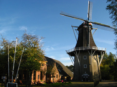
Noteer als antwoord F het vierde cijfer van het
jaartal boven het halfrond raampje van de molen.
Op naar het zevende waypoint. Je komt langs de haven. Door de
toename van vrachtverkeer over de weg wordt de haven niet meer door
vrachtschepen gebruikt. Vroeger deden vele vrachtschepen de haven
aan om de omliggende dorpen te bevoorraden.
Noteer de een na laatste letter van de naam van de brug als
antwoord G, waarbij A=1, B=2, enzovoort.
Volg de bocht naar links en ga naar waypoint acht. Hier staat
een horecagelegenheid. Noteer de letter die het meest in de naam
voorkomt in de halfronde naam op de gevel boven het balkon als
antwoord H, waarbij A=1, B=2, enzovoort.
Ga nu naar het laatste waypoint (Hint: ..Willinge.. , huisnummer
15). Noteer als antwoord I het cijfer tussen de
haakjes: Wat stelt de figuur voor in de cirkel van de windwijzer?
Een mens (1), een dier (2) of een symbol (3).
Met alle antwoorden kan je het eindcoördinaat berekenen. Hier
ligt de cache verborgen:
N 53°2 (G-A) . (D-(FxE)) ((HxF)+F) - E 006°2 (D-I-F) .
(B+C) ((CxFxI)+B)
Graag de cache goed afdekken!
Het terrein is toegankelijk van zonsopgang tot
zonsondergang.
We hebben schriftelijke toestemming van de beheerders van het
terrein.
Als u de cache gevonden heeft kunt u een bezoek brengen aan
Arboretum de Notoarestoen (de tuin van de notaris), tegenover de
parkeerlocatie. De tuin is 2 hectare groot en bevat een
plantencollectie van ongeveer 1.000 verschillende soorten,
waaronder ongeveer 600 soorten rododendrons. In de maanden april en
mei bloeien de meeste soorten rododendrons, maar ook in de maanden
daarna bloeien er veel.
Of u kunt een bezoek brengen aan het hertenkamp in het
Eenrummerbos, of de rasechte Groninger Blaarkoppen, beide ongeveer
100 meter naar het oosten. De Groninger Blaarkop is een oud
runder-ras. Ze lopen in het zomerseizoen los aan de zuidkant van
het bos in het kader van ecologisch beheer van het terrein.
English translation
Park on the above coördinate. From here the cache starts. The
cache lets you see some nice locations in the village and is
approximately 3 km long. Underway a number of questions are asked
or tasks are given. With the answers one can calculate the
endcoördinate.
The cache is suitable for the entire family and can be done on
bicycle. The route is on hard surface, except for the last 50
meters which is over a wide path of crushed shells.
Eenrum
Around 600 years BC first people established themselves in the
Groningse coast area. They lived firstly in spring and summer in
this area. In the autumn and winter their houses were wiped out by
the sea. By raising the ground, called a 'wierde', one could live
in this region the whole year. Of the wierde of the village Eenrum
it has been adopted that it has been inhabited since the year 200
BC. The village arose as agrarian settlement. The Romanesque-Gothic
church from the 13e centuries and the corn mill De Lelie (the lily)
are both visible of quite a distance.
The rural core, where the route passes by, has been designated
as protected rural face. The village has approximately 1560
inhabitants.
From the parkingplace go to the first waypoint. Count the number
of large and medium pineapples on the fence, the answer is
A.
From here to the second waypoint. What is made here? The sixth
character of the dutch word notes as an answer B,
when A=1, B=2, etc.
Follow the bend in the road to the left and go to waypoint
three. If you now look down the street you can see the altitude
difference by the wierde. Count the number of beams on one of the
present benches, as the answer of C.
Now on to the fourth waypoint. You are now on the oldest and
highest spot of the village in the middle of the wierde. The
altitude of the wierde is 4.16 meters above Normaal Amsterdams Peil
(NAP. In English: Amsterdam Ordance Datum. Currently NAP is close
to mean sea level at the Dutch coast ). The Romano-Gothic church is
built in the thirteenth century and stands in the middle of the
wierde. The Renaissance tower is built between 1646 and 1652. With
50 meters it is the highest building of the village. The
zoepenbrijklokje (in English buttermilkpulpbells, buttermilk was in
former days frequently on the menu) sounds since 1752 daily on 8 o
clock, 12 o clock and 6 o clock and tells the inhabitants it's time
to eat.
Which star can be seen from the church? The fourth character of
the name of the star is answer D, where A=1, B=2,
etc.
As from here it goes further to the fifth waypoint, a monument
for Jewish victims of the second world war. Underway you'll come
along an old red rural pump. The pump can be seen easily from the
church. It is one of in sum 3 cast-iron rural pumps which still
stand on the wierde. It is a welpomp of 1871 and was the
predecessor of the modern plumbing. The pump has been out of use
for 50 years and in 1997 and 1998 it has been restored. Underway
you come along Grand Hotel de Kromme Raake, the smallest hotel in
the world. The hotel has two indications in the Guinness Book of
Records. An indication because it the smallest hotel is in the
world. The other indication because during the opening the largest
bottle Beaujolais in the world was used. The hotel has been named
after to a small sea arm which flowed through Eenrum.
Find the youngest victim on the list of the monument. Note as
answer E the figure used most in that line.
Follow the rest of the route by going to the sixt waypoint. You
're standing in front of the windmill De Lelie (the lily). In
former days there were 3 corn mills in this street, of which only
De Lelie has remained. The mill has been built in 1862. In the
summer the mill is operated on Wednesday afternoon and Saturday
afternoon by volunteers. Note as answer F the
fourth figure of the year above the halfround window above the door
of the mill.
Now go to waypoint seven. You come along the port or harbour. By
the increase of lorry traffic, cargo ships are not used anymore in
the port. In former days a lot of cargo liners came the port to
supply the neighbouring villages.
Note the after last character of the name of the bridge as
answer G, where A=1, B=2, etc.
Follow the road to the left and go to waypoint eight. You're at
a hotel/bar. Write down the character which is most present in the
name of the hotel written on the wall above the balcony as answer
H, where A=1, B=2, etc.
Now go to the last waypoint (Hint: ..Willinge.. , house number
15). Note as an answer I the figure between the
brackets: What presents the character in the circle of the wind
indicator? A human (1), an animal (2) or a symbol (3).
With all answers you can calculate the end coordinate. The cache
is lies here:
N 53°2 (G-A) . (D-(FxE)) ((HxF)+F) - E 006°2 (D-I-F) .
(B+C) ((CxFxI)+B)
Please cover the cache properly!
The area is accessible from sunrise to sunset.
We have written authorisation of the administrators of the
area.
If you have found the cache you can bring a visit to Arboretum
the Notoarestoen (the garden of the notary), across the parking
area on the first coördinates mentioned. The garden is 2 hectares
large and contains a collection of plants of approximately 1,000
different types, among which approximately 600 types rododendrons.
In the months of April and May the garden is at its best because a
lot of rododendrons are flowering, but also in the months
afterwards the flowering continues.
Or you can pay a visit to the deer camp in the Eenrummer forest,
or the purebred Groninger Blaarkoppen, both located at a 100 meters
east. Groninger Blaarkop is an old cow race. They are held in the
summertime on the south side of the forest for ecological
management of the area.
Op 12/12/2008 geplaatst door Dwirrel en tot en met 16/09/2010
onderhouden.
Vanaf 17/09/2010 onderhouden door Vawaca.