Le Grand Traict & les marais salants
Version française :
Les marais salants de Guérande et le Grand Traict occupent une dépression tectonique entre deux failles parallèles de direction ONO/ESE (schéma n°1), qui se sont formées il y a 300 millions d’années.
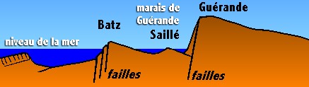
Schéma n°1
Sur ce sol granitique sont, ainsi, apparues les îles de Batz et du Croisic en face du territoire de Guérande (schéma n°2). Au fil du temps et au gré des variations du niveau de la mer, des dépôts de sable ont progressivement réuni les deux îles à la terre pour former ce que l’on connaît actuellement : le Traict et les marais salants de Guérande.
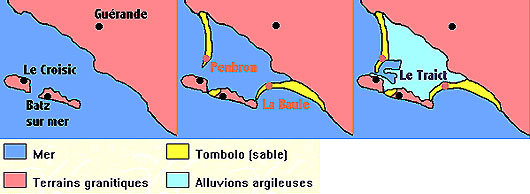
Schéma n°2
Les coordonnées de cette earthcache se situent sur la pointe de Pen Bron, point d’entrée de l’Océan Atlantique dans cette lagune vaseuse, refuge de nombreuses espèces d’oiseaux et zone d’exploitation du célèbre Sel de Guérande.
Pour valider cette cache, vous devez répondre aux 2 questions suivantes et photographier le clocher du Croisic que l’on peut observer de l’autre côté du chenal (Vous pouvez logguer "found it" puis envoyez vos réponses par mail via notre profil sur geocaching.com et joignez votre photo à votre log)
- Au Nord-Ouest de votre position, vous pouvez voir un phare. Quelle est sa couleur (réponse A) ?
- Les pavés sous vos pieds sont disposés de manière à former un cercle, un carré ou un triangle (réponse B) ?
English Version :
The salterns of Guérande and the “Grand Traict” occupy a tectonic depression between two parallel faults of direction WNW / ESE (picture 1), which formed towards -300 million years.
Picture 1
On this granitic ground, appeared islands of Batz and of Croisic in front of the territory of Guérande (picture 2). Over the years and according to the variations of the sea-level, deposits of sand gradually gathered both islands in the earth to form what we actually know as the “Traict” and the salterns of Guérande.
Picture 2
The above coordinates of this earthcache are located on Pen Bron's headland, point of entry of the Atlantic Ocean to this muddy lagoon, refuge of numerous species of birds and production area of the famous Salt of Guérande.
To validate this cache, you have to answer the following two questions and photograph the bell tower of Croisic, which we can observe on the other side of the fairway (Log "Found it" and then send us your answers by email via our geocaching.com profile and join your photo to your log).
- In the Northwest of your position, you can see a little lighthouse. What is its color (answer A) ?
- The cobblestones under your feet are arranged so as to form a circle, a square or a triangle (answer B) ?
Sources :
- Claire KONIG (http://www.futura-sciences.com)
- Géologie de la Région de Guérande