Please feel free to write log in your mother language.
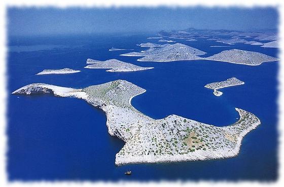
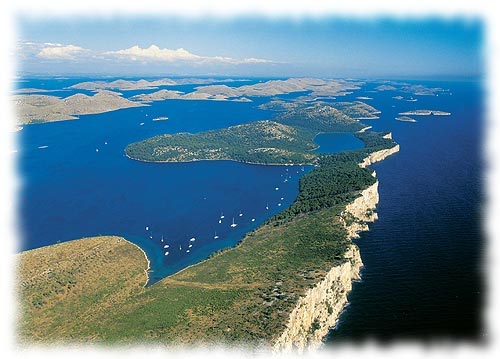
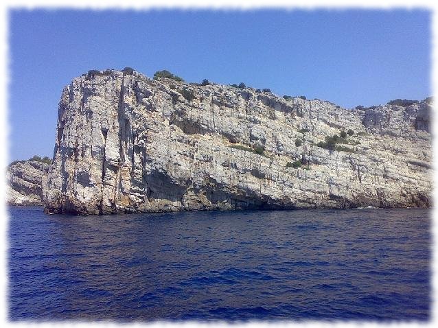
 Stretching along the central part of the Croatian Adriatic, are the Kornati islands. With their immense natural beauty, diverse coastlines, and preserved marine ecosystem, most of the Kornati islands were declared a National park in 1980. National park Kornati sizes about 220 km2 which consists of many islands, islets and reefs. National park Kornati was named after the biggest island in the group. This area is a specific geological phenomenon. Some of the past geological events in this area are strikingly reflected in the well-known Crowns of Kornati. The vertical cliffs of Kornati islands facing the open sea are the most popular phenomenon of this park. The Crowns are actually the surface of a large tectonic fault stretching from Istria and ending somewhere in Central Dalmatia (perhaps even further to the south), caused by the global movement of Africa to the north and its “crashing” into Europe. Vegetation on the islands is minimal, giving the islands a bald look, however, nature still thrives with plant life on the rocks. Crystal clear water, and uncover the all kinds of reefs, shellfish and many species of fish below the surface.
The Kornati islands were populated in prehistoric times; findings of stone hatchets at the bottom of the hill Pasinka on the islands of Kornati confirm the stated. The Kornati islands were a frequent target for invaders and thieves, from the Romans and the Venetians to the aristocracy from Zadar. Although today the Kornati islands are only populated during the summer months, old field and fishing houses spread out in secluded inlets on the Kornati islands, give away the presence of their owners. There is no electricity or fresh water springs on the islands.
The Kornati islands are a real heaven for yachtsmen, divers and all those who enjoy the solitude of untouched and the magnificence of nature. There are 20 restaurants on the Kornati islands which serve fish specialities. You can get to the Kornati islands by boat (if you own or you rent), or by organised boat excursions offered by tourist agencies. For more information you can visit the public bureau „Nacionalni Park Kornati “in Murter. The park is located about seven nautical miles from the island of Murter.
Interesting things to see:
Islet of Taljuric - because of its oval shape it looks like a plate. It is dangerous for boats, because it is often covered with water.
Island Piskera - is the second largest island in the national park, it was once the main fishing centre on the Kornati islands with a warehouse for salted fish.
Mala (little) Proversa – is a shallow passage between Dugi (long) island and the island of Katine. Ancient Roman ruins approximately 90m long are visible in the sea, which were once above sea level.
Bay of Spinuta - in the bay, leftover wall ruins are visible of an Ancient Roman salt factory or of a fish cultivating pond
To log cache you have to attach a photo of you, with your GPS device, with Kornati on backround and answer via profileto this questions:
- How many islands consists national park Kornati?
- What is the highest point of national park Kornati?
- What is name of biggest island in the group?
&
U središnjem dijelu hrvatskog Jadrana proteže se jedinstveno kornatsko otocje. Zbog izuzetne prirodne ljepote, velike razvedenosti obale, ocuvane prirode te bogatog morskog ekosustava, godine 1980. veci dio Kornatskog otocja je proglašen nacionalnim parkom. Nacionalni park Kornati zauzima oko 220km2, a u okviru parka se nalazi iz moga otoka, otocica i hridi.
Vegetacija na otocima je vrlo oskudna. Ipak, priroda pobjeduje skromnim biljem na kamenjaru. Kristalno bistro more otkriva reljefno dno razlicitih oblika, crvene koralje, školjke i mnoge vrste riba.
Kornati su u prapovijesti bili naseljeni. O tome svjedoci nalaz kamene sjekire podno brda Padinka na otoku Kornatu. Kornati su cesto bili meta osvajaca i pljackaša, od Rimljana, Mlecana do zadarske gospode. Iako su danas Kornati nastanjeni samo ljeti, težacke i ribarske kucice, razasute po dobro zašticenim uvalama Kornata, odaju prisustvo njihovih vlasnika. Na Kornatima nema struje niti izvora vode.
Kornatsko otocje predstavlja pravi raj za nauticare, ronioce i sve one koji žele uživati u osami netaknute i velicanstvene prirode. Na Kornatima postoji oko 20 restorana sa ribljim specijalitetima. U nacionalni park se može doci brodom (vlastitim ili iznajmljenim) ili u organizaciji turistickih agencija koje organiziraju izlete. Detaljnije informacije mogu se dobiti u prostorijama Javne ustanove „Nacionalni park Kornati“ u Murteru. NP se nalazi na udaljenosti oko sedam morskih milja od Murtera.
Zanimljivosti:
Otocic Taljuric - ovalnim oblikom nalik je na tanjur. Opasan je za plovila, jer je cesto prekriven morem.
Otok Piškera - drugi po velicini otok u nacionalnom parku, nekadašnje središte ribarskog života na Kornatima, sa skladištima za usoljenu ribu.
Mala Proversa - Plitak prolaz izmedu Dugog otoka i otoka Katine. U moru su vidljivi ostaci rimske gradevine dugacke 90m, koja je u rimsko doba bila iznad morske površine.
Uvala Špinuta - u uvali se vide ostaci podmorskog zida stare rimske solane ili ribnjaka.
Ako htete zapisati ovu cache, uradite vaši sliku sa GPS a Kornati na pozadine a posalji rešenje za pitanje mailom:
- Koliko otoke je u nacionalnim parku Kornati?
- Kako visoko je najvisi mac od sve otoke?
- Kako se zove najveci otok?
&
Popis v slovencine mozno posluzi aj ceskym cacherom.
V strednej casti chorvátskeho Jardranu sa rozprestiera jedinecné súostrovie Kornati. Vdaka výnimocnej prírodnej kráse, velkej clenitosti pobrežia, zachovanej prírode, ako aj bohatstvu morského ekosystému, bola väcšia cast Kornatského súostrovia vyhlásená za národný park. Suostrovie Kornati zaberá približne 220 km2, a v rámci parku sa nachádza mnoho ostrovov, ostrovcekov a skalných útesov.
Vegetácia na ostrovoch je velmi chudobná. V boji o prežitie v drsných podmienkach aj tak vyhráva zivot a na takmer holých kamenoch možno nájst skromné rastlinstvo. Kryštálovo cisté more dokonale odkrýva rozmanité tvary reliéfu morského dna, cervené koraly, mušle a mnohé druhy rýb.
Kornati boli v dávnej minulosti osídlené. Svedcia o tom nálezy kamennej sekery na úpätí vrcha Padinka na ostrove Kornat. Kornati boli casto cielom dobyvatelov a zbojníkov, od Rimanov, Mljetcanov až po zadarských pánov. V sucasnosti sú Kornati osídlené len v lete, iba rybárske clny a chalupy, skryté v dobre chránených zátokách, signalizuju prítomnost svojich majitelov. Na Kornatoch nie je rozvedená elektrická energia, ani pramen sladkej vody. Kornatské súostrovie predstavuje skutocný raj pre moreplavcov, potápacov a všetkých, ktorí by radi vychutnávali samotu nedotknutej prírody. Na Kornatoch sa nachádza asi 20 reštaurácií s pravými rybími špecialitami.
Do národného parku sa môžete dopravit lodou (vlastnou alebo prenajatou), alebo prostredníctvom turistických kancelárií, ktoré organizujú výlety. Podrobné informácie môžete získat v priestoroch verejnej ustanovizne «Národný park Kornati» v Murteri. NP je od Murtera vzdialený asi sedem námorných míl.
Zaujímavosti:
Ostrovcek Taljuric - svojím okrúhlym tvarom pripomína tanierik (podla toho aj jeho pomenovanie, ktoré v preklade znací tanierik). Je nebezpecný pre plavidlá, pretože je casto zaliaty morom.
Ostrov Pištera - druhý najväcší ostrov zo skupiny, niekdajšie stredisko rybárskeho života na Kornatoch, so skladištami pre solené ryby.
Mala Proversa - plytký prieliv medzi ostrovmi Dugi otok a Katine. V mori sú viditelné pozostatky rímskej stavby dlhej 90m, ktorá pocas rímskeho obdobia bola nad hladinou mora.
Zátoka Špinuta - v zátoke je možné vidiet pozostatka podmorskej steny starorímskej soliarne a rybníka.
Pre zalogovalie tejto cache je potrebne prilozit k logu fotku s GPS z oblasti Kornati a odpovedat cez profil na nasledovne otazky (odpovede na otazky mozete poslat aj v slovencine alebo cestine) :
- Z kolkych ostrovov sa sklada narodny park suostrovie Kornati?
- Ako vysoko je najvyssi bod suostrovia?
- Ako sa volá najväcsi ostrov suostrovia?
Im mittleren Teil der kroatischen Adria erstrecken sich die einzigarten Kornaten-Inseln. Wegen ihrer besonderen Schönheit, der grossen Gliederung der Küste, der unberührten Natur sowie einem besonders reichen Meeresökosystem, wurde 1980 ein Großteil der Kornaten als Nationalpark unter Naturschutz gestellt. Die Fläche des Nationalparks beträgt etwa 220km2, und innerhalb des Parks befinden sich viele Inseln, Inselchen und Felsen.
Die Vegetation auf den Inseln ist sehr spärlich. Dennoch, die Natur siegt mit einfachen Pflanzen am Kalkstein. Kristallklares Wasser enthüllt vor unseren Augen die abwechslungsreichen Formen des Küstenreliefs, die ins Meer sinken, rote Korallen, Muscheln und verschiedenste Fischsorten.
Die Inseln waren schon in prähistorischer Zeit besiedelt, wovon der Fund einer Steinaxt am Fuße des Berges Padink auf der Insel Kornat zeugt. Die Kornaten waren oft Ziel von Eroberern und Räubern, von Römern, Venezianern bis zu Adeligen aus Zadar. Obgleich die Kornaten heute nur im Sommer bewohnt sind, Landhäuser und Fischerhäuser, zerstreut über gut geschützte Buchten der Kornaten, verraten die Anwesenheit ihrer Besitzer. Auf den Kornaten gibt es weder Strom, noch Wasserquellen.
Die Kornaten-Inseln stellen ein wahres Paradies für Nautiker, Taucher und alle, die gerne die Einsamkeit der unberührten herrlichen Natur geniessen möchten, dar. Auf den Kornaten gibt es ungefähr 20 Restaurants mit Fischspezialitäten.
Den Nationalpark kann man mit dem Boot (eigenem oder gemieteten) besuchen oder mittels der Organisation von Reiseagenturen, die Ausflüge organisieren. Nähere Informationen erhält man in den Räumlichkeiten der öffentlichen Anstalt «Nationalpark Kornati» in Murter. Der Nationalpark befindet sich in einer Entfernung von etwa sieben Seemeilen von Murter.
Sehenswürdigkeiten
Inselchen Taljuric - ovale Form ähnlich eines Tellers. Gefährlich für Schiffe, da es oft vom Meer bedeckt wird.
Insel Piškera - zweitgrößte Insel im Nationalpark, einst Mittelpunkt des Fischerlebens auf den Kornaten, mit einem Lager für eingesalzene Fische.
Mala Proversa - seichte Durchfahrt zwischen der Insel Dugi Otok und der Insel Katina. Im Meer sind 90m lange Überreste römischer Bauwerke sichtbar, die zu römischer Zeit über der Meeresoberfläche lagen.
Bucht Špinuta - in der Bucht sieht man unter der Wasseroberfläche Wandüberreste eines alten römischen Salzwerkes oder Fischteiches.
Damit Du diesen Cache loggen kannst, poste ein Foto von Dir mit dem GPS in der Hand und den Kornaten im Hintergrund und sende die Antworten auf folgende Fragen über das Profil.
- Aus wie vielen Inseln besteht der Kornaten Nationalpark?
- Wie hoch ist der höchste Punkt im Kornaten Nationalpark?
- Wie heißt die größte Insel im Kornaten Nationalpark?
Thanx to MountainNinja for German translation and to my Tina for English & Serbo-Croat translation
 The most exciting way to learn about the Earth and its processes is to get into the outdoors and experience it first-hand. Visiting an Earthcache is a great outdoor activity the whole family can enjoy. An Earthcache is a special place that people can visit to learn about a unique geoscience feature or aspect of our Earth. Earthcaches include a set of educational notes and the details about where to find the location (latitude and longitude). Visitors to Earthcaches can see how our planet has been shaped by geological processes, how we manage the resources and how scientists gather evidence to learn about the Earth. To find out more click HERE.