Excuse me Sir. There's a hole in my island
Portugal - Azores (S. Miguel)
From the guidelines: "People do not need to wait for permission to log your EarthCache. Requiring someone to wait is not supported by the EarthCache guidelines. People should send their logging task answers to you, then log your EarthCache. When you review their logging task answers, if there is a problem, you should contact them to resolve it. If there is no problem, then their log simply stands."
Azores, somewhere south of S. Miguel Island
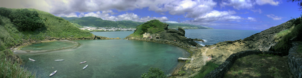
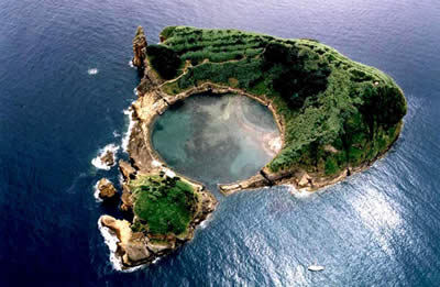
The Ilhéu de Vila Franca do Campo is located in the southern coast of S. Miguel Island approximately 1km from the coast and the village which gives its name.
This small island is made up of two islets: the “Pequenino” (Portuguese for small) islet and the Grande (Portuguese for large) islet which, as the name implies, makes up the larger of the two structures. These two islets define a crater some 150 m in diameter that communicates with the Atlantic Ocean via a narrow channel located in the north of this island.
|
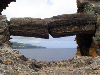 Photo from Ilhéu Photo from Ilhéu |
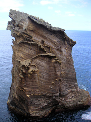
Photo from Ilhéu |
The island was discovered in 1537 and was also once upon a time the site of a military fort. The island remains deserted apart from numerous species of birds, molluscs, invertebrates and plants. However, in the summer months the island is invaded on a daily basis by hordes of sun seekers and bathers that arrive on the island; at a rate of about 600 per day, via boat.
The Intra crater zone is characterised by a sand bank that is crescent-shaped and seems to be influenced by seasonal variations sand but seems to result from the relative force of the water that flows across the fissures and the predominant wind direction.
The breaker zone is dominated by blocks of basaltic rock and the island results from the marine erosion of a volcanic cone of tuffaceous nature.
The EarthCache
Please note that access to the island is solely by boat and that collecting of any live species of animals and plants is STRICTLY PROHIBITED.
In order to claim your found you need to reply correctly to the following questions:
1- What colour is the sand present in the crescent-shaped sand bank?
2- Do you see different coloured minerals in this sand?
3- What are the rocks that make up the entrance of the channel into the crater?
4- Are there any fissures present in the channel?
And finally you are encouraged to place lots of photos in your log (but none that give the answers away).
E-mail me the answer and the image to ffortes@ptero.com .

A special thanks to DanielOliveira who have contributed to this EarthCache. You can visit his notable EarthCache work in:
http://www.geocaching.com/seek/nearest.aspx?tx=c66f5cf3-9523-4549-b8dd-759cd2f18db8&u=danieloliveira